CAMEX-3 JPL Surface Acoustic Wave (SAW) Hygrometer
Table of Contents
Introduction
Dewpoint vs. Frostpoint
Defined as the temperature at which a gas of given composition at constant pressure is saturated with water vapor, dewpoint is closely correlated with water vapor pressure and is independent of the air temperature. For moist air, this correlation is accurately quantified by the steam tables, which tabulate the water vapor pressure as a function of the temperature of a planar surface of pure water. Similar tables exist for the water vapor pressure as a function of ice temperature, which correlate the frostpoint with water vapor pressure. The unique value of a dewpoint/frostpoint hygrometer is that it provides a direct measurement of the temperature at which a surface will start to collect condensation, and the temperature at which a cloud will begin to form in open air.
Theory of Operation
The measurement of dewpoint/frostpoint is usually accomplished by apparatus designed to approximate the saturation temperature of air containing an unknown quantity of water vapor. Chilled-mirror hygrometers cool a mirror in contact with moist air until condensation forms on the surface. Condensation is detected optically by monitoring the reflectivity of the mirror, and the temperature of the mirror is controlled to maintain an equilibrium between condensation and evaporation in the presence of changing humidity. Manufacturers of chilled-mirror hygrometers typically specify an accuracy of ±0.2 degree Celsius, although better accuracy has been reported in the literature. Using a two-stage thermoelectric cooler (TEC), chilled-mirror hygrometers measure dewpoint/frostpoint over a range of -35 to 25 degrees Celsius. Larger systems, employing 4- or 5-stage TECs, can measure frostpoint down to -80 degrees Celsius, and cryogenic systems have been developed that measure frostpoint as low as -100 degrees Celsius. By comparison, relative humidity sensors are far less accurate and stable, and cover a smaller range of humidity. Chilled-mirror hygrometers have been used for in situ measurements of atmospheric humidity on airplanes and high-altitude balloons.
The SAW Micro-Hygrometer
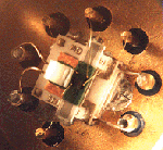 Developed at the Jet Propulsion Laboratory (JPL), this hygrometer uses a surface acoustic wave (SAW) device (seen at left) as a sensitive detector of condensation in lieu of the more traditional chilled mirror and light beam approach. The SAW device is a quartz crystal designed to support high-frequency acoustic oscillations. Because these oscillations are quite sensitive to surface effects, condensation produces a measurable shift in the resonance frequency of the SAW device. A two-stage TEC electronically heats or cools the SAW device, while a platinum resistor (thermistor) is used to monitor the temperature. The SAW hygrometer measures dewpoint by establishing equilibrium between evaporation and condensation on the surface of the SAW device. Using a SAW device as a fast, high-sensitivity moisture sensor, a feedback controller measures the condensation on the sensor surface, and responds by heating or cooling the sensor to maintain equilibrium. The equilibrium temperature under feedback control is a measure of dewpoint or frostpoint, depending on the phase of the condensed moisture. One of the strengths of the SAW device is its fast response time compared to traditional chilled mirror hygrometers. This is due in large part to the ability of the TEC and feedback mechanisms to respond very quickly to dewpoint changes. Developed at the Jet Propulsion Laboratory (JPL), this hygrometer uses a surface acoustic wave (SAW) device (seen at left) as a sensitive detector of condensation in lieu of the more traditional chilled mirror and light beam approach. The SAW device is a quartz crystal designed to support high-frequency acoustic oscillations. Because these oscillations are quite sensitive to surface effects, condensation produces a measurable shift in the resonance frequency of the SAW device. A two-stage TEC electronically heats or cools the SAW device, while a platinum resistor (thermistor) is used to monitor the temperature. The SAW hygrometer measures dewpoint by establishing equilibrium between evaporation and condensation on the surface of the SAW device. Using a SAW device as a fast, high-sensitivity moisture sensor, a feedback controller measures the condensation on the sensor surface, and responds by heating or cooling the sensor to maintain equilibrium. The equilibrium temperature under feedback control is a measure of dewpoint or frostpoint, depending on the phase of the condensed moisture. One of the strengths of the SAW device is its fast response time compared to traditional chilled mirror hygrometers. This is due in large part to the ability of the TEC and feedback mechanisms to respond very quickly to dewpoint changes.
Experimental Setup and Discussion
Setup
During the CAMEX-3 deployment, the SAW hygrometer was setup as follows. A Rosemount-type probe, mounted on the left foremost window of the NASA DC-8, sampled the outside air and guided it through stainless steel tubing towards the hygrometer. For redundancy, two SAW hygrometers were used. One of the hygrometers failed early in the campaign (August 15, 1998) and was never recovered. The other hygrometer functioned well throughout the mission (August 10 - September 22, 1998). The TEC could maintain a maximum temperature differential of approximately 70 C between the SAW surface and the TEC base. Thus, to measure dewpoints/frostpoints as low as -65 C, the TEC had to be cooled down to at least -25 C, i.e. well below ambient cabin temperature (20 C). In order to achieve such results, the TEC-hygrometer assembly was placed in a finned cavity (a "beehive"), which extended from the window into the airstream. The TEC was thus well coupled with the outside air, and within some Mach compression effects, the temperature of the TEC was maintained low enough (typically -25 C at 35,000 ft) to allow dewpoint/frostpoint measurements as low as -65 C. The feedback controllers for the hygrometers were mounted on shelf, which was attached to the window. The controllers were linked to a computer by RS-232 cables which extended from the window to the experimenter's rack. The experimenter role was to monitor the operation of the SAW and occasionally modify the feedback parameters for optimal performance.
Discussion of Experimental Results
The SAW hygrometer, like any other dewpoint/frostpoint hygrometer, measures the equilibrium temperature between the surface phase and the vapor phase. Because there is no direct measurement of the phase present on the surface (liquid or solid), there is a potential ambiguity in the phase-dependent conversion of equilibrium temperature to water vapor pressure. There may be some subtle effects in the measured signal that supply the needed information, and work is still in progress to resolve this issue. Nevertheless, from a comparison with the JPL laser hygrometer as well as other laboratory data, it appears that the SAW actually provides dewpoint data. In other words, only liquid seems to condense on the surface of the SAW device even at very low temperatures. A study is in progress to confirm this interesting phenomenon and provide a satisfactory explanation. As mentioned below, salt may actually have contaminated the surface of the SAW device. There is experimental evidence that salt-saturated media may promote supercooled regimes (i.e. condensation of water instead of ice at temperatures well below 0 C). On the one hand, the presence of salt on the SAW surface may explain the tendency of the SAW hygrometer to measure dewpoint (as opposed to frostpoint). On the other hand, contamination with salt changes the dewpoint calibration, because the equilibrium represented by the steam tables is only valid for pure water.
The SAW hygrometer measured the humidity of the air that had been collected by the Rosemount probe, and was thus compressed. This compression effect basically raised the vapor pressure of the (undisturbed) air that was supposed to be analyzed. In order to account for this phenomenon, the air pressure was measured very close to the hygrometer sensor (slightly downstream of it). With the assumption that the water vapor mixing ratio of the sampled air does not change during compression (conservation of mass), the actual dewpoint of the undisturbed air can be inferred from a measurement of the dewpoint and pressure of the sampled air, and the static pressure of the undisturbed air as measured by the DADS instruments.
This pressure correction requires the use of a thermodynamic relation whose form depends on the phase of the condensed state (liquid or solid). Because the air temperature was always well below freezing, we used the thermodynamic relation based on the equilibrium between water vapor and ice. Note that this correction is not exact, for the following two reasons:
- the phase at the surface of the hygrometer is not known, and thus it is not known which thermodynamic relation to use (liquid or solid phase equilibrium);
- as explained below, the hygrometer surface was probably contaminated with salts, which in principle forbids the use of either thermodynamic relation, since these are valid for pure water only.
(NOTE: The JPL-SAW team plans in the near future to characterize the contaminated surface in terms of salt properties and content, and hopefully derive an appropriate thermodynamic relation for the equilibrium saturation properties.)
Surface Contamination and Subsequent Data Calibration
A convenient feature of the SAW hygrometer is that the instrument calibration consists of calibrating the temperature sensor that monitors the SAW surface. The correlation of the water vapor pressure with the measured dewpoint temperature does not require calibration, because the water vapor pressure over pure water is a well-known function of the temperature. As long as the thermistor which monitors the surface temperature is accurate, the output should be an indication of the dewpoint/frostpoint. However, this scenario is valid only if the condensation surface is free of any impurities, which might prevent or encourage the condensation of water molecules. Salt crystals, for instance, effectively raise the measured equilibrium temperature.
Dewpoint measurements with the SAW hygrometers were consistent with other measurements on the DC8 until August 13, 1998. By August 15, 1998, the dewpoint readings had changed significantly (compared to the chilled mirrors aboard the DC-8). It was apparent that the problem lay with the SAW hygrometer calibration, because the equilibrium temperature was higher than the ambient temperature in measurements conducted on the ground. Possible explanations of the observed calibration shift include a permanent change in the thermistor resistance, and contamination of the surface with salt. Because of the timing of the calibration shift, the fact that the problem appeared simultaneously with both sensors, and the observed stability of the calibration of sensor 1 after the initial shift, our working hypothesis is that contamination was responsible for the calibration shift, with salt-contaminated aerosols as the probable source. The DC-8 was posted at Patrick Air Force Base, which was adjacent to the ocean (literally a couple hundred feet). Even though the Rosemount probe was dutifully covered with a protective sack after each flight and during non-operation of the aircraft, there were long periods of time during taxiing, take-off and landing when the probe was exposed to salt from ocean spray. At this time, the JPL-SAW team believes that sea salt was responsible for the unusual functioning of the hygrometer. Interestingly, the effect did not get worse over the days. The SAW continued to function in a consistent manner, though yielding a higher than expected dewpoint value.
In order to correct for the contamination effect, the SAW did have to be calibrated after the Florida deployment. The calibration was performed in the laboratory against a standard chilled mirror hygrometer. For consistency, it was decided that all the data prior to August 13, 1998, would be corrected as well, using calibration data measured in the laboratory before the mission (in July, 1998) All data collected after August 15, 1998, was corrected with the post-mission calibration.
The second hygrometer suffered from similar symptoms, but in this case, the effects of a gradual failure of the thermistor caused the measured dewpoints to continue shifting to higher values as days passed by. By August 23, 1998, this hygrometer had topped off to its maximum value (corresponding to an open circuit condition at the thermistor), and could not be recovered.
Other Issues
Feedback control issues
Like any dewpoint/frostpoint hygrometer, the SAW strongly relies on a feedback control system to maintain a saturation state on its surface. The feedback mechanism, which is still being improved, sometimes induces oscillations or overdamping, which the experimenter can correct by manually entering new feedback parameters. Similarly, the chilled mirrors aboard the DC-8 (which also rely on a feedback mechanism) sometimes behaved erratically but often times were left alone until atmospheric conditions were such that stability was recovered. In the case of the SAW hygrometer, we chose for the SAW experimenter to intervene immediately and fix the problem in order to maximize the amount of reliable data. Some portions of the data were thus filtered to remove high frequency oscillations (1 Hz or higher). Overdamping could not be corrected after the mission, but can be easily spotted by comparing with the JPL laser hygrometer.
Flow rate issues
The JPL-SAW team discovered that flow rate affected dewpoint/frostpoint values - a higher flowrate yielding a correspondingly higher dewpoint/frostpoint. The flowrate was adjusted during the test flights (August 3 and August 6, 1998) to circa 1 liter/minute in order to provide the most reliable data for all dewpoint values. Nevertheless, during the CAMEX-3 campaign, the SAW hygrometer sometimes responded very slowly and read higher than expected dewpoint values while trying to track very low dewpoints (around -65 C). (The hygrometer was probably not at fault, though, because it was noticed that on a previous mission aboard a radiosonde, the SAW performed very reliably at even lower dewpoints.) The flowrates are a possible culprit, but the issue has not been settled as of this writing (May 99).
Pressure sensors
The pressure sensors (used for the vapor pressure correction, see paragraph below) were calibrated before the flight with a 5 Volt excitation voltage. During the actual flight, the voltage was maintained at a slightly higher value (~5.1 V) and the output was kept unbuffered, with a resulting 0.1 0.000000e+00rror in the pressure reading, and a resulting dewpoint shift of less than 0.1 K. The needed corrections were actually properly quantified after the mission, but were not implemented in this data set for the vapor pressure correction (paragraph b). Nevertheless, since this correction is straightforward and exact, it will be applied in the final data set. This readme will be updated to reflect those changes.
Water drops, ice particles and anomalous dewpoints
It was noticed that as the aircraft traveled through clouds, SAW recorded dewpoint temperatures that were larger than ambient temperature. In comparison, the JPL laser hygrometer indicated a dewpoint value very close to ambient temperature, which is an indication of a saturated state. Obviously, the SAW hygrometer was recording a higher vapor content than actually present. It is speculated that the additional vapor content results from the vaporization (or sublimation) of water droplets (ice crystals) in the probe head. It is thus not a sensor defect, but a property of the collecting probe. Interestingly, the EG&G and GE hygrometers (also on the DC-8) behaved similarly while flying through clouds. It is not surprising since they also sampled the outside air with air collecting probes onto which drops or ice crystals may have vaporized. The effect is probably more pronounced for the GE and EG&G probes since they are very close to the fuselage and may record the extra vapor from the impact of the drops and ice particles against the body of the aircraft. It is astonishing that this phenomenon has gone unnoticed (or at least unreported), especially with commercial hygrometers such as the GE and EG&G which seem to have been mounted identically on many (if not all) research aircraft (cf. University of North Dakota Citation). Instead of ascribing a negative value to this phenomenon, the JPL-SAW team are actually trying to take advantage of SAW dewpoint data for evaluating the cloud water content. A dewpoint measurement in a cloud does not yield any interesting information besides the fact that dewpoint is very nearly equal to ambient temperature. Our probe configuration may actually help in providing additional information about the cloud properties (cloud water content). The team hopes to produce valuable data in the near future regarding this phenomenon, especially in conjunction with the CAPAC group (also known as the Ames Aerosol group) who gathered detailed information about the cloud aerosol properties during CAMEX-3.
File Naming Conventions
The convention used for filenames is as follows:
98[numerical day of the year]-[start_time_Z].[end_time_Z]-[flight_number]-[aircraft]-saw-[sensor]-[data_version].txt
For a CAMEX3 mission on year1998, August 29 (numerical day of the year=241), the NASA DC-8 aircraft using the SAW Hygrometer sensor 1 (s1) on (mission flight number 980412) recorded dewpoint from 19:10 Z until 02:54 Z. The version 1 of the data is labeled as:
98241-1910.0254-980412-dc8-saw-s1-ver1.txt
Data Format
Data is in ascii text format, as is shown below:
|
s1_0810_time
|
s1_0810_DP
|
14.9668
14.9668
14.9669
14.9669
14.9669
14.967
14.967
14.9671
14.9671
.
.
.
|
6.00598
5.99698
5.99757
5.99698
5.99698
6.00598
6.00598
6.00598
6.00598
.
.
.
|
These are the first lines of the data from the mission in paragraph 3 above (cmx3SAW-98241-1910.0254-980412-dc8-s1-ver1.txt). The first row of data tells that these data are from sensor #1 (s1) on August (08) 10th(10) and that the first column is time, the second is the recorded dewpoint in Celsius. Time is reported in minutes and thousandths of minutes (rounded). This turns out to be almost six measurements per second.
Browse imagery is not available at this time.
Contact Information
To order these data or for further information, please contact:
Global Hydrology Resource Center
User Services
320 Sparkman Drive
Huntsville, AL 35805
Phone: 256-961-7932
E-mail: support-ghrc@earthdata.nasa.gov
Web: http://ghrc.nsstc.nasa.gov/
|


