CAMEX-4 ER-2 Lightning Instrument Package (LIP)
Table of Contents
Introduction
The fourth field campaign in the Convection and Moisture Experiment series (CAMEX-4) ran from 16 August to 25 September, 2001 and was based out of Jacksonville Naval Air Station, Florida. CAMEX-4 focused on the study of tropical cyclone (hurricane) development, tracking, intensification, and landfalling impacts using NASA-funded aircraft and surface remote sensing instrumentation. The NASA DC-8 carried numerous instruments durnig the the experiment.
Instrument Description
The ER-2 Lightning Instrument Package (LIP) consists of eight state of the art digital electric field mills and a dual-tube Gerdien conductivity probe. These field mills allow the determination of the vector components of the electric field (i.e., Ex, Ey, Ez ). These data will greatly improve our knowledge of the electrical structure of storms overflown, particularly when the ER-2 passes storms off-center or encounters complex storm (and thus, charge and generator) geometries.
Each field mill incorporates self-calibration capabilities that reduce the time required to obtain a full aircraft calibration. In addition, the electric field signals are digitized at each mill and transmitted as a digital data stream, reducing signal noise and simplifying aircraft integration. The ER-2 electric field mills and the conductivity probe are compact sensors, each weighing less than 10 lbs.
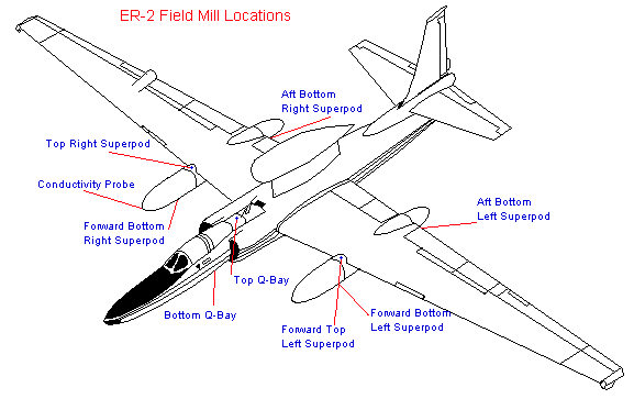
Field Mill Location and Data Collection System
The field mills are installed on the top and bottom of the aircraft just aft of the pilot's cockpit along the centerline of the plane (the bottom one is mounted on the aft section of the AMPR faring) and on the superpods (three mills per pod) as shown on the diagram below.
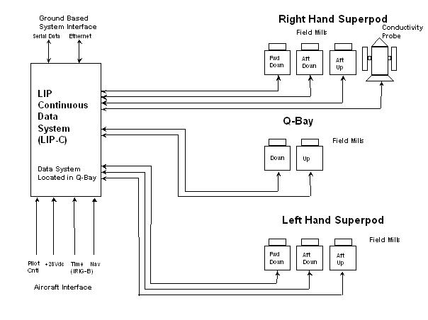
A schematic diagram of the ER-2 LIP instrumentation package is shown below. In this configuration, the field mills measure the components of the electric field over a wide dynamic range extending from fair weather electric fields (i.e., a few to tens of V/m) to large thunderstorm fields (i.e., tens of kV/m). The field mills also provide a measurement of the electric charge (Q) on the aircraft. Total lightning (i.e., cloud-to-ground, intracloud) is identified from the abrupt electric field changes in the data. Often it is possible to differentiate between intracloud and cloud-to-ground discharges. The conductivity probe is installed on either the right or left hand superpod nose cone. The conductivity probe measures the air conductivity at the aircraft flight altitude. The probe consists of a pair of Gerdien capacitor type sensors so that the contributions to the total conductivity due to positive and negative ions are obtained simultaneously throughout each flight. Storm electric currents can be derived using the electric field and air conductivity measurements.
Data Products
The data products produced by ER-2 LIP system includes:
- Electric field components (Ex, Ey, and Ez)
- Aircraft self-charge (EQ)
- Period: continuous record, entire flight
- Resolution: 0.1s (but data is oversampled at 50 Hz)
- Comments: Total lightning (cloud-to-ground, intracloud) can be determined from electric field changes in the data. Data will also provide information on the electrical structure within and around the thunderstorms and hurricanes encountered (often this will be the only means to assess the electrical state of the clouds overflown). The electric currents flowing above storms can be derived using the electric field and air conductivity measurements.
- Air conductivity period: continuous record, entire flight
- Resolution: 0.1s (but data is oversampled at 50 Hz)
- Comments: Simultaneous measurements provided of both polar components of the air conductivity (i.e., contributions from positive and negative ions). Storm electric currents can be derived when used with the electric field data.
Data Format
Data are 'tarred' into daily (mission) data files of the form:
c4elip_yyyy.jjj_mmm.tar
where c4elip represents CAMEX4 and the ER-2LIP instrument, yyyy.ddd is the four digit year and day of year, mmm is the mission number.
When untarred, this will yield a data file and a .gif file. File naming convention for the data file is:
CAMEX4_ER2_LIP_1.00_yyyy.jjj_mmm
where CAMEX4_ER2_LIP identifies the experiment and instrument, 1.00 is the version number, yyyy.jjj is the four digit year and day of the year, mmm is the mission number. This file is in HDF format, and may be read using any common HDF reader. More information about HDF may be found at the HDF homepage.
LIP_2001.220_112.gif
is the file name for the image file that may be viewed with almost any image viewer.
Contact Information
To order these data or for further information, please contact:
Global Hydrology Resource Center
User Services
320 Sparkman Drive
Huntsville, AL 35805
Phone: 256-961-7932
E-mail: support-ghrc@earthdata.nasa.gov
Web: http://ghrc.nsstc.nasa.gov/
|


