CAMEX-4 ER-2 MODIS Airborne Simulator (MAS)
Table of Contents
Introduction
The MODIS Airborne Simulator (MAS) is a modified Daedalus Wildfire scanning spectrometer which flies on a NASA ER-2 high altitude research aircraft and provides spectral information similar to that provided by the Moderate Resolution Imaging Spectroradiometer (MODIS) launched on the EOS-TERRA platform on 19 December 1999 and the EOS-AQUA platform on 4 May 2002.
Instrument Description
The MAS spectrometer acquires high spatial resolution imagery in the range of 0.55 to 14.3 microns. A total of 50 spectral bands are available in this range. The data is fed into a 50-channel digitizer which records all 50 spectral bands at 12 bit resolution. The MAS spectrometer is mated to a scanner sub-assembly which collects image data with an instrument field of view of 2.5 mrad, giving a ground resolution of 50 meters from 20000 meters altitude, and a cross track scan width of 85.92 degrees.
This article, published in the Earth Observer Magazine, describes the history, development, and in-flight performance of the MAS Instrument. (December 1992). The article is also available in the documents provided with the dataset.
The MODIS Airborne Simulator (MAS) records information in 50 multispectral bands at 16-bit resolution. The original AMES document can be seen here.
Documentation
Extensive documentation about the instrument, calibration, geolocation and data extraction is found in the MAS Level-1B Data User's Guide found on the MAS AMES server. It is also included in the documentation with the dataset.
Data Products and File Format
Data files are in HDF 4 format, and the data are organized into individual straight-line flight tracks. Each file contains one straight-line flight track, and defines a granule of data. In general there are 10 to 20 flight tracks in a given flight. In order to extract data from data files, the HDF software library must be compiled and installed. The source code is available from NCSA through their HDF Information Server.
- The data files are available from our server should you wish to download them..
- The file name as shown for the data file is of the form MASL1B_01mmm_tt_yyyymmdd_ssss_eeee_V01.hdf where
- MASL1B - indicates the MAS instrument, Level 1B data
- 01mmm - Dryden Flight number- 01 (for 2001) mmm a unique mission number
- tt - track sequence
- yyyymmdd- calendar year, month and day
- ssss- start time in UTC
- eeee- end time in UTC
- V01.hdf- Data version #1, in HDF format
Each flight contains a flight information file ASCII form with the extension .sum. These files give information on each of the above mentioned flight tracks (lat, lon, time, solar elevation and azimuth and aircraft heading at the start of the track) as well as what are called 'Global Attributes'. Global Attributes include mission specific information (aircraft, dates, etc.). An example is called c4emas_01-130.sum and is available for download from here. The file name indicates that this file was for a CAMEX4 mission using the MAS instrument on Dryden flight number 01-130 and that it is a summary file.
Each flight has associated with it a spectral response file that is presented in .html form and is viewable here.
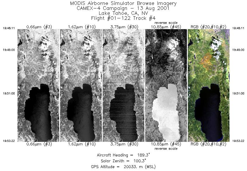
Last but not least is a browse image of each track. These are in .jpg format. One example is shown below, and has the filename c4emas_01122_04.jpg. Note that the naming convention describes a jpg image from MAS during the CAMEX-4 experiment, mission number 1-122, the forth track.
Contact Information
To order these data or for further information, please contact:
Global Hydrology Resource Center
User Services
320 Sparkman Drive
Huntsville, AL 35805
Phone: 256-961-7932
E-mail: support-ghrc@earthdata.nasa.gov
Web: http://ghrc.nsstc.nasa.gov/
|


