CAMEX-4 TOGA Radar
Table of Contents
Introduction
The Convection And Moisture EXperiment (CAMEX) is a series of field research investigations sponsored by the Earth Science Enterprise of the National Aeronautics and Space Administration (NASA). The fourth field campaign in the CAMEX series (CAMEX-4) ran from 16 August to 25 September, 2001 and was based out of Jacksonville Naval Air Station, Florida. CAMEX-4 focused on the study of tropical cyclone (hurricane) development, tracking, intensification, and landfalling impacts using NASA-funded aircraft and surface remote sensing instrumentation.
The NASA TOGA radar is a modified WSR-74 C-band Doppler radar that was first used in the Tropical Ocean-Global Atmosphere Coupled Ocean Atmosphere Response Experiment (TOGA COARE), an international research program investigating the scientific phenomena associated with the interactio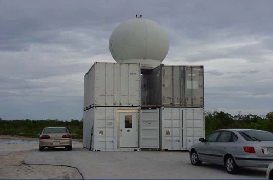 n between the atmosphere and the ocean in the warm pool region of the western Pacific. Since that experiment, the TOGA radar has been used in numerous experiments. n between the atmosphere and the ocean in the warm pool region of the western Pacific. Since that experiment, the TOGA radar has been used in numerous experiments.
The TOGA radar is easily transportable, and consists of an antenna which is usually mounted upon the conex (container express) boxes which house the display consoles, power supplies and air conditioning units as shown in the image to the right.
Instrument Description
Specifics of the TOGA radar are shown in the table below.
| Frequency |
C-Band: 5600-5650 MHz |
| Peak Power |
500 kW |
| Polarization |
Linear |
| half-power beamwidth |
1.5 degrees |
| elevation angle range |
Zero to 90 degrees |
| Variables |
Z, V, W |
Data Products
There are two types of files associated with the TOGA radar data: radar data in universal format (uf) and browse images showing a PPI view at 0.5 degrees showing reflectivity. Data files are large, and are presented in 'gzipped' daily files. Typical daily file size is on the order of 0.5 to 1.5 Gigabytes.
The raw data files are available by request to GHRC User Services, or via our on line ordering system, HyDRO. Only one data file is available on our FTP site because they are too large for our server to accomodate them all. Technical support for these data is available as noted below.
Browse imagery is also available via HyDRO.
File Naming Convention
Data are 'gzipped' into daily data files of the form:
TOGA_vol_yymmdd_tttt.uf.gz
where TOGA_vol represents the TOGA radar volume scan, 01mmdd_tttt is the year (2001), mm is the month, dd is the day, tttt is the volume scan time. uf indicates that these data are in universal format, and it is gz 'gzipped'.
When 'gunzipped' (UNIX) or extracted using WINZIP, this file will yield a data files for use in the SIGMET IRIS program. File naming convention for this unzipped/uncompressed data file is:
TOGA_vol_yymmdd_tttt.uf
Naming convention is similar to the zipped file. Again, this file is in universal radar format.
Browse imagery files are named as:
TOGA_vol_yymmdd_tttt_swp0_dz.jpg
with nomenclature similar to that shown in the data files with the addition of swp0_dz indicating a 0.5 degree elevation sweep showing radar reflectivity. Imagery files may be viewed with any common viewer.
Data Extraction
Data are in Universal Format. For information about extracting imagery and tabular data, see here.
Contact Information
Address Scientific issues to:
Dr. John Gerlach
Branch Head
Observational Science Branch
laboratory for Hydrospheric Processes
NASA GSC/Wallops Flight Facility
Wallops Island, VA 23337-5019
phone: 757-824-1515
fax: 757-824-1036
gerlach@wff.nasa.gov
Technical issues should be addressed to:
Dr. Paul A. Kucera
Assistant Professor
Department of Atmospheric Sciences
P.O. Box 9006
University of North Dakota
Grand Forks, ND 58202
Ph: 701-777-6342
Fax: 701-777-5032
pkucera@aero.und.edu
To order these data or for further information, please contact:
Global Hydrology Resource Center
User Services
320 Sparkman Drive
Huntsville, AL 35805
Phone: 256-961-7932
E-mail: support-ghrc@earthdata.nasa.gov
Web: http://ghrc.nsstc.nasa.gov/
|


