The Long Range Lightning Detection Network
These data are restricted to collaborators that have a working relationship with the NASA Marshall Space Flight Center (MSFC) Lightning Group.
Table of Contents
Introduction
This README file contains information on cloud-to-ground lightning data produced by a Long Range Lightning Detection Network operated by the Vaisala Group. The Vaisala website is located at Vaisala Thunderstorm Online Application Portal and should be contacted by non-NASA affiliated researchers for obtaining lightning data.
Vaisala (previously Global Atmospherics) has been providing this experimental data set to the National Centers for Environmental Prediction/ Aviation Weather Center (AWC) located in Kansas City, MO since 1996. The data are transmitted from the GAI network control center to the Global Hydrology and Climate Center via the AWC. The AWC is using these oceanic lightning data as input to their operational oceanic weather hazard alerts referred to as International SIGMETs (depicting significant meteorology).
The network is comprised of the U.S. National Lightning Detection Network (NLDN) and the Canadian Lightning Detection Network (CLDN), the latter commissioned for operations in February 1999. These two networks comprise an integrated North American Lightning Detection Network (NALDN) consisting of 187 sensors. The sensors are connected to a central processor that records the time, polarity, signal strength, and number of strokes of each cloud-to-ground lightning flash detected over the Gulf of Mexico, the Atlantic, and the Pacific Oceans. A combination of time of arrival and direction finding technology is used to locate each flash. The NLDN uses 47 Advanced Lightning Direction Finders (ALDFs) in combination with 59 LPATS III electric field sensors. The CLDN uses 26 IMPACT/ES sensors and 55 LPATS-IV sensors. Depending on the location within the network, GAI claims a location accuracy of 500 meters, with a detection probability between 80-90 percent, varying by region. These data are ingested in real-time and stored in a raw data file.
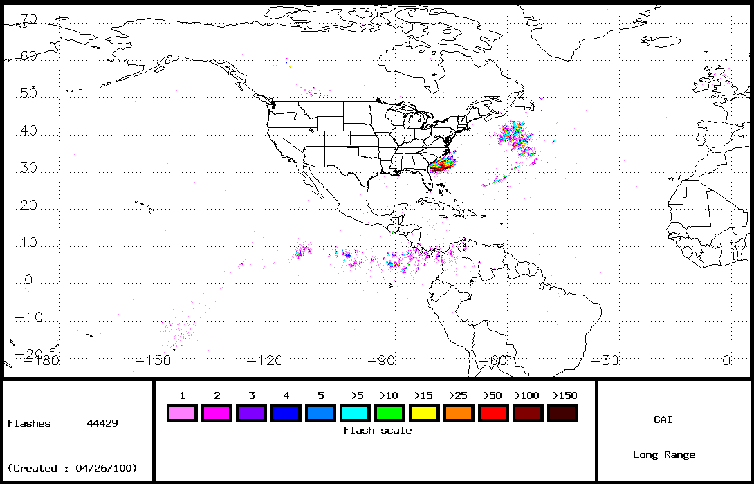
Long Range Lightning Browse Imagery
The Global Hydrology Resource Center (GHRC) generates a browse cloud-to-ground lightning image from the data collected from the Long Range Lightning Detection Network. This image is created by summing the number of flashes per pixel per day for the entire region. Each pixel has dimensions of approximately 22x22 km. The image spatial range is from -25S to 170N and from 175E to 5E and omits lightning over CONUS. The total number of flashes recorded for that day is displayed in the lower left side of the image, and a color bar scale representing the number of flashes per pixel appears at the bottom of the image.
An example image is shown below. Flashes as far as Great Britian and the central South Pacific near the island of Tahiti are recorded by the Long Range system.
File Format for Raw Data
Raw Long Range Lightning data is saved as ASCII text files as shown in the sample data line below. Each field of data is separated by a space. Below the example data line appears a table showing each field and its associated length. Spaces are not counted in the field length.
Note to CONUS NLDN Users: the format for the Long Range NLDN differs from that of the CONUS NLDN lightning raw data.
Sample data line:
010197 23315200 311951 -758680 -50
| Field name |
Length of field |
Example |
Translation |
| Date |
6 |
010197 |
1 Jan 97 |
| Time (UTC) |
8 |
23315200 |
2331hr 52.00sec |
| Latitude (degrees) |
6 |
311951 |
31.1951N (S is negative) |
| Longitude (degrees) |
8 |
-758680 |
75.8680W (W is negative) |
| Signal Strength(kA) |
3 |
-50 |
50kA in a negative stroke |
File Naming Convention
A raw data file is produced for each day of the year. The naming convention for the Long Range Detection Network raw data file is:
Lrflashyyyy.ddd_daily.lit.raw where yyyy is the year and ddd is the day of year.
Citing Lightning Data
Our data sets are provided through the NASA Earth Science Data and Information System (ESDIS) Project and the Global Hydrology Resource Center (GHRC) Distributed Active Archive Center (DAAC). GHRC DAAC is one of NASA's Earth Observing System Data and Information System (EOSDIS) data centers that are part of the ESDIS project. ESDIS data are not copyrighted; however, in the event that you publish our data or results derived by using our data, we request that you include an acknowledgment within the text of the article and a citation on your reference list. Examples for general acknowledgments, data set citation in a reference listing, and crediting online web images and information can be found at: http://ghrc.nsstc.nasa.gov/uso/citation.html
References
Cummins, K. L., R. B. Pyle, and G. Fournier, 1999. An Integrated North American Lightning Detection Network, Proceedings of the 11th International Conference on Atmospheric Electricity, Guntersville, AL, June 7-11.
Cramer, J. A., and K. L. Cummins, 1999. Long-Range and Trans-Oceanic Lightning Detection, Proceedings of the 11th International Conference on Atmospheric Electricity, Guntersville, AL, June 7-11.
Cummins, K. L., M. J. Murphy, E. A. Bardo, W. L. Hiscox, R. B. Pyle, and A. E. Pifer, 1998. A Combined TOA/MDF Technology Upgrade of the U. S. National Lightning Detection Network, J. Geophys. Res., 103, 9035-9044.
Idone, V. P., D. A. Davis, P. K. Moore, Y. Wang, R. W. Henderson, M. Ries, and P. F. Jamason, 1998. Performance evaluation of the U. S. National Lightning Detection Network in eastern New York, 1, Detection Efficiency, J. Geophys. Res., 103, 9045-9056.
Contact Information:
To order these data or for further information, please contact:
Global Hydrology Resource Center
User Services
320 Sparkman Drive
Huntsville, AL 35805
Phone: 256-961-7932
E-mail: support-ghrc@earthdata.nasa.gov
Web: http://ghrc.nsstc.nasa.gov/
|


