Hurricane and Severe Storm Sentinel (HS3)

Hurricane and Severe Storm Sentinel (HS3) Global Hawk Advanced Vertical Atmospheric Profiling System (AVAPS) Dropsonde System


Preservation Item Source Location
Preflight / Pre-Ops Calibration
Instrument Description

AVAPS Dropsonde System

Science Data Products
Raw and Derived Products

Hurricane and Severe Storm Sentinel (HS3) Global Hawk Advanced Vertical Atmospheric Profiling System (AVAPS) Dropsonde System V2

Science Data Product Documentation
Product Team

Gary Wick, Terry Hock, Kate Young, and Holger Voemel

Processing and Algorithm Version History Versions 1-2
Product Application

AVAPS Dropsonde System

Software and Related information
Science Data Product Software

ASPEN

AVAPS Software

AVAPS Dropsonde System


Science Data Product Validation

Hurricane and Severe Storm Sentinel (HS3) 2012 Global Hawk Dropsonde Data Analysis Summary

Hurricane and Severe Storm Sentinel (HS3) 2013 Global Hawk Dropsonde Data Analysis Summary

Hurricane and Severe Storm Sentinel (HS3) 2014 Global Hawk Dropsonde Data Analysis Summary

Science Data Software Tools


ASPEN

AVAPS Software


AVAPS Dropsonde System


HS3 Global Hawk Cloud Physics Lidar (CPL)


Preservation Item Source Location
Preflight / Pre-Ops Calibration
Instrument Description

McGill et al. (2002): Cloud Physics Lidar: Instrument description and initial measurement results

Yorks et al. (2011): Airborne validation of cirrus cloud properties derived from CALIPSO lidar measurements: Spatial properties

Science Data Products
Raw and Derived Products Hurricane and Severe Storm Sentinel (HS3) Global Hawk Cloud Physics Lidar (CPL)
Mission Calibration Data
Calibration Method

McGill et al. (2002): Cloud Physics Lidar: Instrument description and initial measurement results

Science Data Product Documentation
Product Team

Matthew McGill and Dennis Hvalka

Product Requirements and Designs

Yorks et al. (2011): Airborne validation of cirrus cloud properties derived from CALIPSO lidar measurements: Spatial properties

Processing and Algorithm Version History

Version 1

Product Generation Algorithm Documentation

McGill et al. (2003): Airborne lidar measurements of aerosol optical properties during SAFARI-2000

Hlavks, et al. (2012): Airborne validation of cirrus cloud properties from CALIPSO lidar measurements: Optical properties

Yorks et al. (2011): Airborne validation of cirrus cloud properties derived from CALIPSO lidar measurements: Spatial properties

Yorks et al. (2011): Statistics of Cloud Optical Properties from Airborne Lidar Measurements

Product Application 

CPL Abstracts

CPL Publications

Software and Related information
Science Data Product Software

Read ATB HD5 software

Read OP HD5 software

Science Data Product Validation

Hlavka et al. (2005): Aerosol and cloud optical depth from GLAS: Results and verification for an October 2003 California fire smoke case

McGill et al. (2002): Cloud Physics Lidar: Instrument description and initial measurement results

Schmid et al. (2003): Coordinated airborne, spaceborne, and ground-based measurements of massive thick aerosol layers during the dry season in southern Africa

Science Data Software Tools

Read ATB HD5 software

Read OP HD5 software


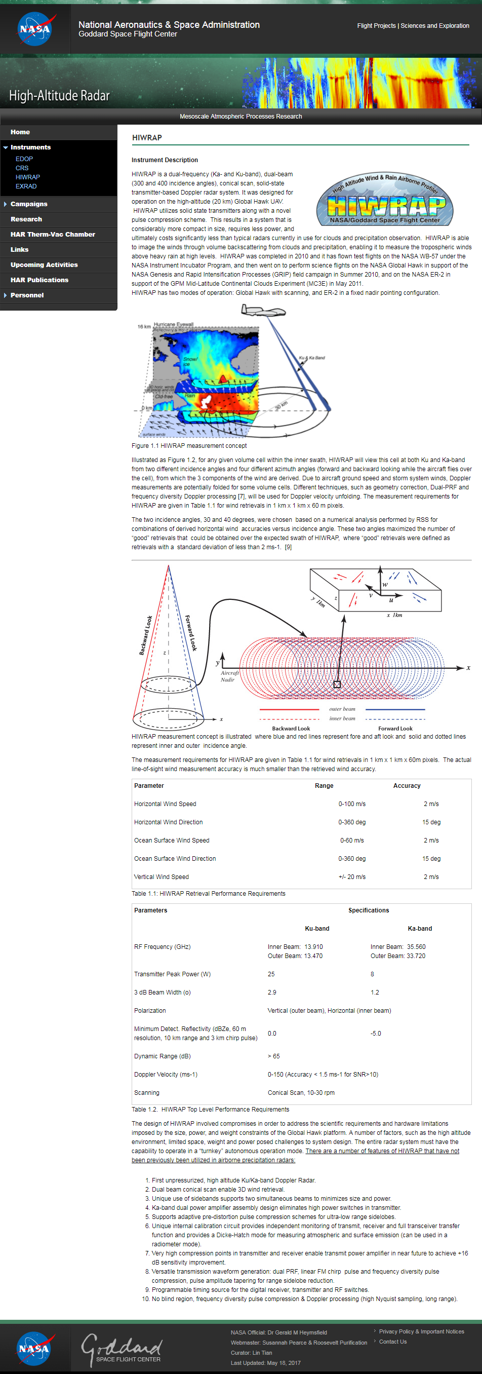
HS3 High-altitude Imaging Wind and Rain Airborne Profiler (HIWRAP)


Preservation Item Source Location
Preflight / Pre-Ops Calibration
Instrument Description

Heymsfield et al. (2006): Development of the High-Altitude Imaging Wind and Rain Airborne Profiler (HIWRAP)

Li et al.: Development of the NASA High-Altitude Imaging Wind and Rain Airborne Profiler

Li et al. (2006): High-Altitude Imaging Wind and Rain Airborne Radar (HIWRAP)

NASA HIWRAP Webpage

Heymsfield et al.: Status of the High-Altitude Imaging Wind and Rain Airborne Profiler (HIWRAP)

Li et al. (2016): The NASA High-Altitude Imaging Wind and Rain Airborne Profiler

HIWRAP (High-Altitude Imaging Wind and Rain Airborne Profiler) eoPortal Directory

Science Data Products
Raw and Derived Products

Hurricane and Severe Storm Sentinel (HS3) High-Altitude Imaging Wind and Rain Airborne Profiler (HIWRAP)

Mission Calibration Data
Calibration Method

Li et al. (2016): The NASA High-Altitude Imaging Wind and Rain Airborne Profiler

Science Data Product Documentation
Product Team

Gerald M. Heymsfield and Lin Tian

Processing and Algorithm Version History

Version 1

Product Generation Algorithm Documentation

Li et al. (2016): The NASA High-Altitude Imaging Wind and Rain Airborne Profiler

Product Application 

HIWRAP (High-Altitude Imaging Wind and Rain Airborne Profiler) eoPortal Directory

Software and Related information
Science Data Product Software

Li et al. (2006): High-Altitude Imaging Wind and Rain Airborne Radar (HIWRAP)

Science Data Product Validation


Heymsfield et al. (2006): Development of the High-Altitude Imaging Wind and Rain Airborne Profiler (HIWRAP)

Li et al.: Development of the NASA High-Altitude Imaging Wind and Rain Airborne Profiler

Li et al. (2006): High-Altitude Imaging Wind and Rain Airborne Radar (HIWRAP)

NASA HIWRAP Webpage

Heymsfield et al.: Status of the High-Altitude Imaging Wind and Rain Airborne Profiler (HIWRAP)


HIWRAP (High-Altitude Imaging Wind and Rain Airborne Profiler) eoPortal Directory

Jacob, et al. (2015): Validation of Rain Rate Retrievals for the Airborne Hurricane Imaging Radiometer (HIRAD)


HS3 Global Hawk High Altitude MMIC Sounding Radiometer (HAMSR)


Preservation Item Source Location
Preflight / Pre-Ops Calibration
Instrument Description

HAMSR (High Altitude MMIC Sounding Radiometer)

Riley et al.: The High Altitude MMIC Sounding Radiometer (HAMSR)

Brown et al. (2011): The High-Altitude MMIC Sounding Radiometer for the Global Hawk Unmanned Aerial Vehicle: Instrument Descriptoin and Performance

Science Data Products
Raw and Derived Products

Hurricane and Severe Storm Sentinel (HS3) Global Hawk High Altitude MMIC Sounding Radiometer (HAMSR)

Mission Calibration Data
Calibration Method

Riley et al.: The High Altitude MMIC Sounding Radiometer (HAMSR)

Brown et al. (2011): The High-Altitude MMIC Sounding Radiometer for the Global Hawk Unmanned Aerial Vehicle: Instrument Descriptoin and Performance


Science Data Product Documentation
Product Team

Bjorn Lambrigtsen

Processing and Algorithm Version History

Version 1


Product Generation Algorithm Documentation

Brown et al. (2011): The High-Altitude MMIC Sounding Radiometer for the Global Hawk Unmanned Aerial Vehicle: Instrument Descriptoin and Performance

Product Application

HAMSR (High Altitude MMIC Sounding Radiometer) from eoPortal Directory

Software and Related information
Science Data Product Software

HAMSR L1B netCDF UI

HAMSR L2 netCDF UI

Science Data Product Validation

HAMSR Product Validation Products

Science Data Software Tools


HAMSR L1B netCDF UI


HAMSR L2 netCDF UI


HS3 Hurricane Imaging Radiometer (HIRAD)


Preservation Item Source Location
Preflight / Pre-Ops Calibration
Instrument Description

Hopkins et al.: Beam Former Development for the NASA Hurricane Imaging Radiometer

Rui et al.: The Hurricane Imaging Radiometer – An Octave Bandwidth Synthetic Thinned Array Radiometer

Jacob et al. (2015): Validation of rain rate retrievals for the airborne Hurricane Imaging Radiometer (HIRAD)

Science Data Products
Raw and Derived Products

Hurricane and Severe Storm Sentinel (HS3) Hurricane Imaging Radiometer (HIRAD)


Mission Calibration Data
Calibration Method

Ruf et al.: Calibration and image reconstruction for the Hurricane Imaging Radiometer (HIRAD)


Science Data Product Documentation
Product Team

Daniel J. Cecil and Sayak Biswas

Processing and Algorithm Version History

Version 1

Product Generation Algorithm Documentation

Ruf et al.: Calibration and image reconstruction for the Hurricane Imaging Radiometer (HIRAD)

Product Application

HIRAD Publications

Software and Related information
Science Data Product Validation


Jacob et al. (2015): Validation of rain rate retrievals for the airborne Hurricane Imaging Radiometer (HIRAD)


Have you used our data? Register for updates