CAMEX-3 NAST-I RADIANCE PRODUCTS
Table of contents
Introduction
The NPOESS Aircraft Sounder Testbed- Interferometer (NAST-I) is a high resolution Michelson interferometer, developed at MIT Lincoln Laboratory, that derives its heritage from the non-scanning High resolution Interferometer Sounder (HIS) developed by researchers at the University of Wisconsin. The NAST-I instrument scans the earth from beneath the ER-2 with a nominal spatial resolution of approximately 2.5 km with a total of 13 earth views in the cross-track direction (the resultant swath width covers about 45 km). The unapodized spectral resolution of NAST-I is 0.25 1/cm within a 590-2810 1/cm (3.6-17 micron) spectral range. The instrument flies in the right superpod of NASA's high altitude ER-2 research aircraft. The infrared radiance measurements obtained from the NAST-I instrument provide detailed spectral characteristics of the atmosphere and land surface along with providing detailed atmospheric temperature and water vapor profiles derived from either physical or regression based retrieval algorithms.
Additional NAST-I information can be found here.
Sorties
The following lists the sorties (the ER-2 official sortie number), date, and brief description of the mission.
- Sortie #98-105 August 5, 1998 (Ferry Flight, DFRC to PAFB)/li>
- Sortie #98-106 August 8, 1998 (Checkout and Andros Overflight) RAM chip failure (no data collected)/li>
- Sortie #98-107 August 13, 1998 (TEFLUN-B mission and Andros Overflight)/li>
- Sortie #98-108 August 15, 1998 (TEFLUN-B mission and TRMM underflight)
- Sortie #98-109 August 23, 1998 (Hurricane Bonnie Eyewall mission and Andros Island overflight)
- Sortie #98-110 August 24, 1998 (Hurricane Bonnie Eyewall Mission)
- Sortie #98-111 August 26, 1998 (Hurricane Bonnie Landfall Mission)
- Sortie #98-112 August 29, 1998 (Hurricane Danielle mission) ER-2 abort (no data collected
- Sortie #98-113 August 30, 1998 (Hurricane Danielle mission) ER-2 short mission
- Sortie #98-114 September 2, 1998 (Hurricane / Tropical Storm Earl mission)
- Sortie #98-115 September 5, 1998 (TEFLUN-B mission and TRMM underflight)
- Sortie #98-116 September 8, 1998 (TEFLUN-B mission)
- Sortie #98-117 September 13, 1998 (EOS Calibration / Validation mission)>
- Sortie #98-118 September 17, 1998 (TEFLUN-B mission)
- Sortie #98-119 September 21, 1998 (Hurricane Georges Eyewall mission)
- Sortie #98-120 September 22, 1998 (Hurricane Georges Synoptic Inflow mission)
- Sortie #98-132 September 23, 1998 relocation to Warner-Robbins AFB, GA
- Sortie #98-136 September 25, 1998 (Hurricane Georges mission)
- Sortie #98-137 September 27, 1998 (Hurricane Georges Landfall mission
- Sortie #98-138 September 28, 1998 (Ferry Flight, RAFB to DFRC)
Browse images: tracks and scenes
These may be found on the
CAMEX3 webpage calendar.
Select a day on which the instrument flew (see above table) and click on
NAST-I. This will bring up a page with thumbnails of each of the browse
images available-- scenes or tracks. Click on any of these and a full screen
image will pop up.
NASTI_VIS: An IDL visualization tool for NAST-I
Because of the complexity of the NAST-I data (it is in NetCDF), a visualization tool has been created to run under IDL version 5.1 or 5.2. IDL is a commercially available program, and is available from Research Industries, Inc. More information may be found about NetCDF here.
The program written for visulaization of NAST-I data is called NASTI_VIS, and can be found either on the GHRC documents site for NAST-I, or can be directly downloaded from the University of Wisconsin as described in the Installation Instructions paragraph 2 below.
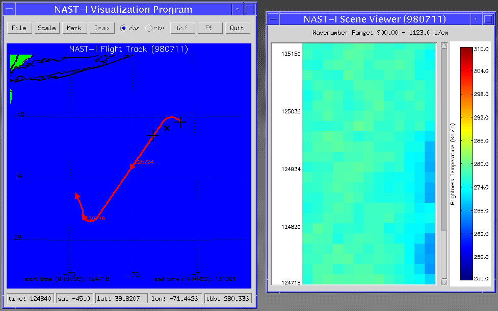
This is a screen shot from the visualization tool showing a flight track segment on the left, and the instrument output on the right.
Beta Version 0.71 released on January 14, 1999 supercedes any older version, in fact older versions will not work with latest datasets.
NASTI_VIS is a freely available IDL 5.1/5.2-based visualization tool for the NPOESS Aircraft Sounder Testbed - Interferometer (NAST-I) netCDF apodized data. The program is an IDL widget based (a.k.a Graphical User Interface) visualization tool useful for analysis of the NAST-I calibrated netCDF format data. NASTI_VIS features the following:
- View any NAST-I wavenumber combination as a Rastor Image having the dimensions of scan angle and time (UTC).
- Flight track map depicting position of the ER-2 aircraft.
- Continuous display of data values updated on the flight track map (time, view angle, latitude, longitude, brightness temperature) when the cursor is moved over the Rastor image. Position of the NAST-I field of view (FOV) is also shown on the flight track map to show relative position of the observation with respect to the flight track.
- View radiance or brightness temperature spectrum by clicking on the Rastor Image- each block on the Rastor image represents a single observation for which the IR spectrum is available.
I- nteractive ZOOM function and radiance or brightness temperture unit selection is available on the spectra plot window.
Installation instructions
The program will run on most platforms (Unix/Linux/Win see below) where IDL 5.1 is installed and your minimum RAM is 128 MB. Just follow these steps:
(1) Check that IDL version 5.1 is installed. (NASTI_VIS will not work in IDL 5.1 demo mode; however, this will be fixed in the IDL 5.1.1 release).
(2) Download the required program files (Windows/Unix users click right mouse button then 'Save Lin k').
(a) NASTI_VIS IDL 5.1 save file NASTI_VIS (IDL version 5.1) widget program
(b) NASTI_VIS IDL 5.2 save file NASTI_VIS (IDL version 5.2) widget program, ALSO once downloaded RENAME nasti_vis_5_2.sav TO nasti_vis.sav if you have IDL 5.2 installed.
(c) IDL 5.1 startup script An optional startup script used to force IDL into 8 bit mode display.
(3) Download sample NAST-I netCDF data file:
NAST-I netCDF longwave IR sample dataset
Running the program NASTI_VIS
1) Change to subdirectory where nasti_vis.sav resides or ensure that your IDL path points to that subdirectory.
(2) Start IDL, and at the IDL > prompt, just run nasti_vis and the widget based program should appear.
(3) If color table problems happen, just grab the idl_startup.pro script and have the IDL_STARTUP path point to idl_startup.pro to force IDL into 8 bit mode display. This startup file tends to solve the vast majority of color table problems that result from running IDL under anything above 8 bit (256 colors) display.
Windows:
This program has NOT been tested in IDL 5.1 under Windows NT 4.0, but is known to work under Windows 95. The program may lock up under the Windows environment if your RAM is less than the 128 MB required.
UNIX/Linux:
This program has been tested in IDL 5.1 under Solaris, AIX, and Linux. So far, there have been no problem reports from users using the above operating systems.
Contact Information
To order these data or for further information, please contact:
Global Hydrology Resource Center
User Services
320 Sparkman Drive
Huntsville, AL 35805
Phone: 256-961-7932
E-mail: support-ghrc@earthdata.nasa.gov
Web: http://ghrc.nsstc.nasa.gov/
|
