|
|
CAMEX-4 DC-8 Dropsonde System Table of Contents
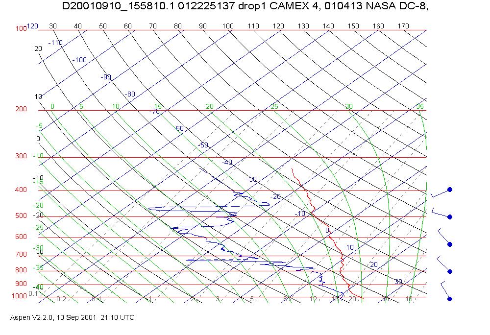
The DC-8 Dropsonde (D8D) system uses Global Positioning System (GPS) dropwindsondes to measure vertical profiles of pressure, temperature, humidity, and wind during descent to the surface. During CAMEX-4, the D8D system released over one hundred and fifty dropwindsondes, nearly 70 of those on the last three days of the experiment. Vertical measurement of the atmosphere goes back many decades with the current dropwindsonde coming into being in 1993. Working in collaboration with the National Oceanic and Atmospheric Administration/ Atlantic Oceanographic and Meteorological Laboratory (NOAA/AOML) and the German Aerospace Research Establishment (DLR), the National Center for Atmospheric Research/ Atmosphere Technology Division (NCAR/ATD) developed a third-generation dropwindsonde using a new sensor module and a GPS receiver from Vaisala, Inc. More accurate wind profiles are now available because of a NCAR/ATD-developed, unique square-cone parachute that reduces the initial shock load and stabilizes the dropwindsonde as it falls. The dropswindsondes are the responsibility of NCAR/ATD/Surface and Sounding Systems Facility who provided the final post experiment quality control processing. The Vaisala page details the system at http://www.vaisala.com, and the GPS dropsonde page at ATD at http://www.atd.ucar.edu/sssf/facilities/dropsonde/gpsDropsonde.html. Content and structure of the D8D filesThere are three files associated with each dropwindsonde released during the experiment: an image of the sounding, a QCed data file, and finally the World Meteorological Organization (WMO) code file (discussed below). These three files are 'tarred' into a daily/mission file with the following naming convention: c4dd8d_2001.ddd_0104mm.tar where c4dd8d is the designator for the DC-8 dropsonde data, 2001.ddd is year and day of year, 0104mm (mm is a sequential number from 01-27) is the official DC-8 mission ID, and tar indicates 'tar' file. Once 'untarred' there will be three files whose naming convention is very straightforward. Images (in .jpg format) are named Drop#_hhmmss.jpg where the # is the release sequence number and hhmmss is the time of the drop. The other two files are the QCed sounding with data in tabular form, and the WMO temp drop code for that sonde. Each of these has the file name in the form Dyyyymmdd_hhmmss.[ext], where D identifies this as data, yyyymmdd is year month date (e.g. 20010908) and hhmmss is the release time in hours, minutes and seconds. The .[ext] is the file extension, and is either QCcls for the QC data file in CLASS format, or wmo for the temp drop code. Browse Images: Drop#_hhmmss.jpgThe suffix '.jpg' identifies this browse image as a plotted sounding in JPG format. The skew-T diagram shows the temperature, dewpoint, and vertical wind profiles measured during the flight of the dropwindsonde. Date, time of release, and mission ID are given in the title of the image. An example of the browse image named Drop1_155810.jpg is shown below:
QC data file: d20010910_155810.QCcls A sample is shown here. Data is in CLASS format- click here for more information. For the purpose of this document, this data has been formatted so that lines are not broken. One simple way to obtain neatly aligned data is to import the raw data text file into a spreadsheet (e.g. Excel) for automatic formatting. Close examination will reveal that the file reads backwards in time from the top of the file to the bottom, consequently pressures decrease from top to bottom making it appear to be a surface sounding. This is the data file as it appears following quality control by NCAR. Otherwise, the file is self explanatory. WMO data file: D20010910_155810.wmo This is the coded temp drop code. For decode information, click here. This is in the format specified by the World Meteorological Organization, thus the file name extension. Below is the temp drop corresponding to both of the above products.
To order these data or for further information, please contact:
|