|
|
GRIP Second Generation Airborne Precipitation Radar Table of Contents
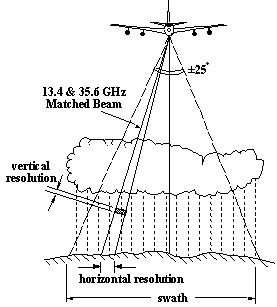
The Second Generation Airborne Precipitation Radar (APR-2) is a dual-frequency (13 GHz & 35 GHz), Doppler, dual-polarization radar system. The APR-2 instrument has a downward looking antenna that performs cross track scans, covering a swath that is +/- 25 degrees to each side of the aircraft path. Additional features include: simultaneous dual-frequency; matched beam operation at 13.4 and 35.6 GHz (the same as GPM Dual-Frequency Precipitation Radar); simultaneous measurement of both "like" and "cross-polarized" signals at both frequencies; doppler operation, and real-time pulse compression (calibrated reflectivity data can be produced for large areas in the field during flight, if necessary). CampaignThe Genesis and Rapid Intensification Processes (GRIP) experiment was a NASA Earth science field experiment conducted August 5 to September 30, 2010. The major goal was to better understand how tropical storms form and develop into major hurricanes. NASA used the DC-8 aircraft, the WB-57 aircraft and the Global Hawk Unmanned Airborne System (UAS), configured with a suite of in situ and remote sensing instruments that were used to observe and characterize the lifecycle of hurricanes. This campaign also capitalized on a number of ground networks and space-based assets, in addition to the instruments deployed on aircraft from Ft. Lauderdale, Florida ( DC-8), Houston, Texas (WB-57), and NASA Dryden Flight Research Center, California (Global Hawk). More information about this Campaign can be found on the GRIP web site: http://grip.nsstc.nasa.gov/
The APR-2 system includes a real-time pulse compression processor, a fully-functional control and timing unit, and a very compact LO/IF module, all of which could be used in spaceborne applications. The cylindrical reflector antenna and linear feed array for the spaceborne PR-2 have been replaced by traveling wave tube amplifiers (TWTAs), front-end electronics, and an offset parabolic reflector antenna with mechanical scanning. The APR-2 operational geometry is shown in Figure 1 below; it looks downward and scans its beam across-track, with each scan beginning at 25 degrees to the left of nadir and ending at 25 degrees to the right. It uses the same scanning antenna reflector as that used for the Airborne Rain Mapping Radar (ARMAR), which consists of a 0.4 m offset reflector antenna with a mechanically scanned flat plate. The APR-2 antenna feed is a dual-frequency feed (13.4 and 35.6 GHz) and the aperture at 35.6 GHz is under-illuminated to provide matched beams at the two frequencies. This choice results in poor Doppler accuracy at Ka-band, but is needed for rain retrieval. |
Additional information on the development and specifics of the APR-2 system can be viewed at this Jet Propulsion Lab web site: http://trmm.jpl.nasa.gov/apr.html File Naming ConventionThe data files are HDF (Hierarchical Data Format), and are named as the example below:
where, Data Format The Principal Investigator provided a Product Handbook which details information concerning the release, data format, missing data, and known issues. Data files are in HDF (Hierarchical Data Format) format and are similar to that from the TRMM Precipitation Radar. Measurements included within the data files are:
These data can be read with most any HDF reader, thus no sample read software is supplied by the data producer. More information about HDF may be found at the HDF group homepage. Sadowy, G. A., A. C. Berkun, W. Chun, E. Im, and S. L. Durden, 2003: Development of an advanced airborne precipitation radar. Microwave J., 46 (1), 84-98. Haddad, Z. S., J. P. Meagher, S. L. Durden, E. A. Smith, and E. Im, 2006: Drop size ambiguities in the retrieval of precipitation profiles from dual-frequency radar measurements. J. Atmos. Sci., 63, 204-217 . Users are invited to address questions and provide feedback to the contact below.
To order these data or for further information, please contact:
|