|
|
NAMMA DC-8 Dropsonde Table of Contents
The DC-8 dropsonde system uses an integrated, highly accurate, GPS-located atmospheric profiling dropsonde, which measures and records current atmospheric conditions in a vertical column below the aircraft. The dropsonde, also known as dropwindsonde or parachute radiosonde, is a small, lightweight (less than 1 lb) cylindrical instrument that falls freely through the atmosphere, slowed somewhat by a small inflatable parachute. This type of instrument offers atmospheric researchers a complete solution for accurate in-situ measurement of the atmosphere. A unique square-cone parachute is used to reduce the initial shock load and to slow and stabilize the descending dropsonde. The parachute is deployed immediately on exit from the launch chute and takes about five seconds to be filled by ram-air. The square-cone parachute is very stable during the descent, reducing or eliminating any pendulum motion of the dropsonde. Once deployed, the launch crew does not expect to see the instrument again. The cost of recovering a dropsonde would likely exceed its value. Also, since they are mostly launched over water, the probability of finding them would be low. Additional information about dropsondes can be found here: http://www.eol.ucar.edu/rtf/facilities/dropsonde/ and here: http://www.vaisala.com/weather/products/dropsonde.html. CampaignThese data files were generated during support of the NASA African Monsoon Multidisciplinary Analyses (NAMMA) campaign, a field research investigation sponsored by the Science Mission Directorate of the National Aeronautics and Space Administration (NASA). This mission was based in the Cape Verde Islands, 350 miles off the coast of Senegal in west Africa. Commencing in August 2006, NASA scientists employed surface observation networks and aircraft to characterize the evolution and structure of African Easterly Waves (AEWs) and Mesoscale Convective Systems over continental western Africa, and their associated impacts on regional water and energy budgets. For more information about the NAMMA Campaign, go to the NAMMA web site: http://namma.nsstc.nasa.gov/ Instrument DescriptionThe dropsonde instrument is ejected from a tube in the underside of the DC8 aircraft. As the dropsonde floats to the surface on a parachute, it continuously measures and transmits via a 400 MHz meteorological band telemetry link, pressure, temperature and relative humidity, as well as GPS-based wind formation data, to the receiving system onboard the aircraft. Sensitive atmospheric sensors and computer electronics inside the dropsonde can measure changes in temperature to within 0.2 deg C, 2% variations in moisture, and wind speeds to within 0.5 m/s. The winds are computed using the Global Positioning System (GPS) and thus the dropsonde also contains a special antenna to track the progress of these satellites. The dropsonde is designed and manufactured through a partnership between the National Center for Atmospheric Research (NCAR) and Vaisala, Inc. During the NAMMA field campaign two different versions of the dropsonde were used. The Rev.D dropsonde, also referred to as GPS121, is an older version. The newer Rev. F version dropsonde uses a GPS receiver based upon u-Blox GPS receiver technology. It is a full up code correlating receiver providing a 12 channel receiver with significant improved tracking performance and reliability over the previous codeless GPS receiver used in the Rev D dropsonde. The new GPS receiver module also provides superior latitude, longitude, and altitude information. File naming conventionThere are three files associated with each dropsonde released during the experiment:
These files are named respectively, following the GHRC naming convention:
where, Data Format Quality Controlled Data Files These data files are in a new "EOL file format", which is similar to the "CLASS format" that has been used in the past, but improved to include a revised header with more detailed sounding information. Section III of the NAMMA dropsonde readme file describes this new EOL file format in detail, and can been found here: https://ghrc.nsstc.nasa.gov/pub/doc/namma/namdrop/readme.NAMMA2006.radiosondes.pdf WMO Code Files These files contain the coded temp drop code, and are in the format specified by the World Meteorological Organization. Decode information can be found at this hurricane hunter's web location, http://www.hurricanehunters.com/, or in this word document: https://ghrc.nsstc.nasa.gov/pub/doc/namma/namdrop/TEMP_DROP_CODE.doc Figure 1 below is a sample temp drop (WMO) file.
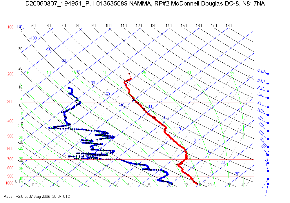
Figure 1 Image Files These image files are skew-T diagrams in PNG format. They show the temperature, dewpoint, and vertical wind profiles measured during the flight of the dropsonde. Date, time of release, and mission ID are given in the title of the image. Figure 2 below is an example of one of the skew-T diagrams.
Figure 2 The data producer is:
To order these data or for further information, please contact:
|