NASA GHRC Collaboration between NASA MSFC and The University of Alabama in Huntsville
  • Access Data
    • Dataset List (HyDRO)
      • View a list of all GHRC dataset holdings using our custom search tool, HyDRO.
    • Search (HyDRO)
      • HyDRO is GHRC's custom dataset search and order tool.

        With HyDRO, you can search, discover, and filter GHRC's dataset holdings.

        HyDRO will also help you find information about browse imagery, access restrictions, and dataset guide documents.
    • NASA Earthdata Search
      • Earthdata is NASA's next generation metadata and service discovery tool, providing search and access capabilities for dataset holdings at all of the Distributed Active Archive Centers (DAACs) including the GHRC.
    • Latest Data (HyDRO)
      • View the latest additions to our data holdings using HyDRO.
  • Measurements
  • Field Campaigns
    • Hurricane Science
      • GHRC has worked with NASA's Hurricane Science Research Program (HSRP) since the 1990's. We are the archive and distribution center for data collected during HSRP field campaigns, as well as the recent Hurricane Science and Severe Storm Sentinel (HS3) Earth Venture mission. Field campaigns provide for intensive observation of specific phenomena using a variety of instruments on aircraft, satellites and surface networks.

        GHRC also hosts a database of Atlantic and Pacific tropical storm tracks derived from the storm data published by the National Hurricane Center (NHC).
    • HS3 (2012-14)
      • Hurricane and Severe Storm Sentinel (HS3) is an Earth Ventures – Suborbital 1 mission aimed at better understanding the physical processes that control hurricane intensity change, addressing questions related to the roles of environmental conditions and internal storm structures to storm intensification.

        A variety of in-situ, satellite observations, airborne data, meteorological analyses, and simulation data were collected with missions over the Atlantic in August and September of three observation years (2012, 2013, 2014). These data are available at GHRC beginning in 2015.
    • GRIP (2010)
      • The Genesis and Rapid Intensification Processes (GRIP) experiment was a NASA Earth science field experiment in 2010 that was conducted to better understand how tropical storms form and develop into major hurricanes.

        The GRIP deployment was 15 August – 30 September 2010 with bases in Ft. Lauderdale, FL for the DC-8, at Houston, TX for the WB-57, and at NASA Dryden Flight Research Facility, CA for the Global Hawk.
    • TC4 (2007)
      • The NASA TC4 (Tropical Composition, Cloud and Climate Coupling) mission investigated the structure and properties of the chemical, dynamic, and physical processes in atmosphere of the tropical Eastern Pacific.

        TC4 was based in San Jose, Costa Rica during July 2007.

        The Real Time Mission Monitor provided simultaneous aircraft status for three aircraft during the TC4 experiment. During TC4, the NASA ER-2, WB-57 and DC-8 aircraft flew missions at various times. The science flights were scheduled between 17 July and 8 August 2007.
    • NAMMA (2006)
      • The NASA African Monsoon Multidisciplinary Analyses (NAMMA) campaign was a field research investigation based in the Cape Verde Islands, 350 miles off the coast of Senegal in west Africa.

        Commenced in August 2006, NASA scientists employed surface observation networks and aircraft to characterize the evolution and structure of African Easterly Waves (AEWs) and Mesoscale Convective Systems over continental western Africa, and their associated impacts on regional water and energy budgets.
    • TCSP (2005)
      • The Tropical Cloud Systems and Processes (TCSP) mission was an Earth science field research investigation focused on the study of the dynamics and thermodynamics of precipitating cloud systems and tropical cyclones. TCSP was conducted during the period July 1-27, 2005 out of the Juan Santamaria Airfield in San Jose, Costa Rica.

        The TCSP field experiment flew 12 NASA ER-2 science flights, including missions to Hurricanes Dennis and Emily, Tropical Storm Gert and an eastern Pacific mesoscale complex that may possibly have further developed into Tropical Storm Eugene.
    • ACES (2002)
      • The Altus Cumulus Electrification Study (ACES) was aimed at better understanding the causes and effects of electrical storms.

        Based at the Naval Air Station Key West in Florida, researchers in August 2002 chased down thunderstorms using an uninhabited aerial vehicle, or "UAV", allowing them to achieve dual goals of gathering weather data safely and testing new aircraft technology. This marked the first time a UAV was used to conduct lightning research.
    • CAMEX-4 (2001)
      • The Convection And Moisture EXperiment (CAMEX) was a series of NASA-sponsored hurricane science field research investigations. The fourth field campaign in the CAMEX series (CAMEX-4) was held in 16 August - 24 September, 2001 and was based out of Jacksonville Naval Air Station, Florida.

        CAMEX-4 was focused on the study of tropical cyclone (hurricane) development, tracking, intensification, and landfalling impacts using NASA-funded aircraft and surface remote sensing instrumentation.
    • CAMEX-3 (1998)
      • The Convection And Moisture EXperiment (CAMEX) is a series of hurricane science field research investigations sponsored by NASA. The third field campaign in the CAMEX series (CAMEX-3) was based at Patrick Air Force Base, Florida from 6 August - 23 September, 1998.

        CAMEX-3 successfully studied Hurricanes Bonnie, Danielle, Earl and Georges, yielding data on hurricane structure, dynamics, and motion. CAMEX-3 collected data for research in tropical cyclone development, tracking, intensification, and landfalling impacts using NASA-funded aircraft and surface remote sensing instrumentation.
    • GPM Ground Validation
      • The NASA Global Precipitation Measurement Mission (GPM) Ground Validation (GV) program includes the following field campaigns:

        a) LPVEx, Gulf of Finland in autumn 2010, to study rainfall in high latitude environments

        b) MC3E, cental Oklahoma spring and early summer 2011, to develop a complete characterization of convective cloud systems, precipitation and the environment

        c) GCPEx, Ontario, Canada winter of 2011-2012, direct and remove sensing observations, and coordinated model simulations of precipitating snow.

        d) IFloodS, Iowa, spring and early summer 2013, to study the relative roles of rainfall quantities and other factors in flood genesis.

        e) IPHEx, N. Carolina Appalachians/Piedmont region May-June 2014, for hydrologic validation over varied topography.

        f) OLYMPEx, Washington's Olympic Peninsula scheduled November 2015-February 2016, for hydrologic validation in extreme coastal and topographic gradients
    • OLYMPEX (Upcoming)
      • The OLYMPEX field campaign is scheduled to take place between November, 2015, and February, 2016, on the Olympic Peninsula in the Pacific Northwest of the United States.

        This field campaign will provide ground-based validation support of the Global Precipitation Measurement (GPM) satellite program that is a joint effort between NASA and JAXA.

        As for all GPM-GV campaigns, the GHRC will provide a collaboration portal to help investigators exchange planning information and to support collection of real-time data as well as mission science, project and instrument status reports during the campaign.
    • IPHEx (2014)
      • The Integrated Precipitation and Hydrology Experiment (IPHEx) was conducted in North Carolina during the months of April-June, 2014.

        IPHEx sought to characterize warm season orographic precipitation regimes, and the relationship between precipitation regimes and hydrologic processes in regions of complex terrain.
    • IFLOODs (2013)
      • The Iowa Flood Studies (IFloodS) experiment was conducted in the central to northeastern part of Iowa in Midwestern United States during the months of April-June, 2013.

        IFloodS' primary goal was to discern the relative roles of rainfall quantities such as rate and accumulation as compared to other factors (e.g. transport of water in the drainage network) in flood genesis.
    • GCPEX (2011-2012)
      • The GPM Cold-season Precipitation Experiment (GCPEx) occurred in Ontario, Canada during the winter season (Jan 15- Feb 26) of 2011-2012.

        GCPEx addressed shortcomings in GPM snowfall retrieval algorithm by collecting microphysical properties, associated remote sensing observations, and coordinated model simulations of precipitating snow. Collectively the GCPEx data set provides a high quality, physically-consistent and coherent data set suited to the development and testing of GPM snowfall retrieval algorithm physics.
    • MC3E (2011)
      • The Mid-latitude Continental Convective Clouds Experiment (MC3E) took place in central Oklahoma during the April–June 2011 period.

        The overarching goal was to provide the most complete characterization of convective cloud systems, precipitation, and the environment that has ever been obtained, providing constraints for model cumulus parameterizations and space-based rainfall retrieval algorithms over land that had never before been available.
    • LPVEx (2010)
      • The Light Precipitation Evaluation Experiment (LPVEx) took place in the Gulf of Finland in September and October, 2010 and collected microphysical properties, associated remote sensing observations, and coordinated model simulations of high latitude precipitation systems to drive the evaluation and development of precipitation algorithms for current and future satellite platforms.

        In doing so, LPVEx sought to address the general lack of dedicated ground-validation datasets from the ongoing development of new or improved algorithms for detecting and quantifying high latitude rainfall
  • Projects
    • HS3 Suborbital Mission
      • Hurricane and Severe Storm Sentinel (HS3) is an Earth Ventures – Suborbital 1 mission aimed at better understanding the physical processes that control hurricane intensity change, addressing questions related to the roles of environmental conditions and internal storm structures to storm intensification.
    • DISCOVER - MEaSUREs
      • DISCOVER was funded by NASA’s MEaSUREs program to provide highly accurate, multi-decadal geophysical products derived from satellite microwave sensors.
    • LIS Mission
      • Lightning observations from the Lightning Imaging Sensors (LIS) aboard the NASA’s TRMM satellite and International Space Station, as well as airborne observations and ground validation data.
    • SANDS
      • The SANDS project addressed Gulf of Mexico Alliance priority issues by generating enhanced imagery from MODIS and Landsat data to identify suspended sediment resulting from tropical cyclones. These tropical cyclones have significantly altered normal coastal processes and characteristics in the Gulf region through sediment disturbance.
    • LANCE AMSR2
      • The Land, Atmosphere Near real-time Capability for EOS (LANCE) system provides access to near real-time data (less than 3 hours from observation) from AIRS, AMSR2, MLS, MODIS, and OMI instruments. LANCE AMSR2 products are generated by the AMSR Science Investigator-led Processing System at the GHRC.
  • Resources
    • Tools & Technologies
      • A collection of tools & technologies developed and/or used by GHRC.
    • Publications
      • View GHRC & ITSC publications on the ITSC website
    • Innovations Lab
      • The GHRC Innovations Lab is a showcase for emerging geoinformatics technologies resulting from NASA-sponsored research at the University of Alabama in Huntsville.
    • Educational Resources
      • A list of resources from NASA, MSFC, and other sources for teachers and students focused on global change, hydrology, and science education.
    • Referencing our data
      • GHRC dataset citation help and examples.
    • Documents
      • Documentation related to GHRC datasets, software, and other offerings.
    • Glossary
      • Terms and their definitions
    • Featured items
      • The latest tools from GHRC.
  • Multimedia
  • About
    • Welcome
      • Local resources, lodging information, and weather to help you plan your visit to GHRC.
    • GHRC Personnel
      • A list to help you keep in touch with our personnel
    • FAQ
      • Frequently Asked Questions about GHRC data and services, and their answers.
    • Data Citations and Acknowledgements
      • GHRC dataset citation help and examples
  • Cite Us
  • Contact Us
feedback
DOCUMENTATION

Documentation

Guide Documents

Dataset PI Documents

Dataset Software

CAMEX-3 Polarimetric Scanning Radiometer (PSR)

Table of Contents

Introduction
Instrument Description
Naming Conventions and Formats
References
Contact Information

Introduction

The Polarimetric Scanning Radiometer (PSR) is a versatile airborne microwave imaging radiometer developed by the Georgia Institute of Technology and the NOAA Environmental Technology Laboratory for the purpose of obtaining polarimetric microwave emission imagery of the Earth's oceans, land, ice, clouds, and precipitation.

The PSR homepage contains a vast amount of information about the instrument itself as well as data from other field campaigns, contact information, and an impressive set of links to other similar sites.

Instrument Description

The PSR consists of a set of five polarimetric radiometers housed within a gimbal-mounted scanhead drum. The scanhead drum is rotatable by the gimbal positioner so that the radiometers can view any angle within 70 deg. elevation of nadir at any azimuthal angle (a total of 1.32 sr solid angle), as well as external hot and ambient calibration targets. The configuration thus supports conical, cross-track, along-track, fixed-angle stare, and spotlight scan  modes. The PSR supports several observational objectives:

(1) to provide polarimetric imagery of the upwelling thermal emission field at several of the most important microwave remote sensing bands covering X to W band in octave intervals and including the 22.235 GHz water vapor line. The current implementation provides full Stokes vector (four parameters Tv, Th, TU, and TV) capability at 10.7 and 18.7 GHz, tripolarimetric capability (Tv, Th, and TU) at 37.0 and 89.0 GHz, and dual polarization capability (Tv and Th) at 21.5 GHz;
(2) to provide the above measurements with absolute accuracy of better than 1 K for Tv and Th, and 0.1 K for TU and TV;
(3) to provide radiometric imaging with both fore and aft look capability (rather than single swath observations);
(4) to provide conical imagery at a variety of surface incidence angles; and
(5) to  provide image resolutions appropriate for spatially- resolved studies of precipitating and non-precipitating clouds, mesoscale ocean surface features, and satellite calibration/validation at Nyquist spatial sampling rates.


Scanhead
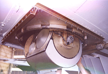
The scanhead (seen in the image to the left) was designed for in- flight operation without the need for a radome (i.e., in direct contact with the aircraft slipstream), thus allowing precise calibration and imaging with no superimposed radome emission signatures. Moreover, the conical scan mode allows the elements of the modified Stokes' vector to be observed without polarization mixing. The PSR scanhead contains an 80486 PC, an analog correlator bank, and five total-power radiometers installed inside a 20" (~51 cm) diameter and 20" (51 cm) long rotating drum. The radiometer antennas are orthogonal linearly-polarized corrugated feedhorns with grooved rexolite lenses. A single dual-band antenna is used for the X- and Ka-band channels. Antenna diameters were chosen to provide beamwidths of 8o (for 10.7, 18.7, and 21.5 GHz) and 2.3o (for 37.0 and 89.0 GHz). All main beam efficiencies are in the 95-97% range and all on-axis cross-polarizations exceed -27 dB.

The scanhead package includes a monochrome CCD telephoto video camera boresighted along the antenna main beams. The camera incorporates an orange filter and vertical polarizer to maximize the contrast of ocean foam against the ocean background and clouds against either ocean or land backgrounds. The PSR has been integrated into the nadir-7 port of the DC-8 for CAMEX3 and will be primarily operated in a 52o conically-scanned mode.

Several major improvements in the scanhead and data system have been implemented in preparation for CAMEX-3. First, the 18-GHz feedhorn and receiver was upgraded to cover two radiometric bands and now includes a fully-polarimetric channel at 18.6-21.7 GHz, and a dual-polarized water vapor channel at 21.3-21.6 GHz. The new K-band receiver is thus sensitive to emissions from both the surface and integrated water vapor. The new receiver is also a direct detecting type rather than superheterodyne. Second, each of the five radiometers will incorporate sub-interval calibration hardware to supplement the standard hot- and ambient-view calibration. The sub-interval calibration hardware switches noise diodes into the RF inputs of the receivers at ~100 msec intervals, pulsing each diode both on and off so as to allow estimation of the radiometer gains and offsets at time intervals comparable to the drift time of receivers. In this manner, uncalibrated gain and offset drift caused by 1/f noise is significantly reduced. Third, the digital correlators in the original scanhead were replaced by analog adding correlators incorporating quadrature hybrid arrays. The analog system will allow measurement of all four Stokes' parameters for the 10- and 18-GHz channels, and the first three Stokes' parameters for the 37- and 89-GHz channel. Finally, using the new canted pyramidal calibration load the absolute accuracy of the PSR is expected to be ~1 K, thus providing excellent capabilities for absolute intercomparisons of PSR measurements with radiative transfer model calculations and TMI measurements.

Naming Conventions and Formats

CAMEX-3 data for PSR is tarred into one large file for ease in distribution. This file is named:

dc8psr_total_data.tar

which when 'untarred' reveals the following files and directories:

  • camex3_data_flight_catalog.doc & camex3_data_flight_catalog.pdf--provides a description of the various CAMEX3 maneuvers listed by PSR serial numbers.
  • flight_description.doc & flight_description.pdf- in tabular form gives date, PSR flight code, UTC time, location/event/objective and comments.
  • level23a_description.doc & level23a_description.pdf- describes the meaning of the various data planes within any level 2.3a data file
  • software_description.doc & software_description.pdf- Self explanatory.
  • 17 sub directories of the form 1998_mmdd/ where mm is the month (08 or 09) and dd is the day of the month.
  • display_23a.zip- contains text file list of flight dates corresponding to the 17 sub-directories above, and Matlab files for use in processing the data.

In each of the daily directories (1998_mmdd) is a subdirectory named level2.3a that contains yet a further subdirectory named SL referring to straight and level flight data. Therein are the Matlab version 5.3 m-files necessary to render calibrated brightness temperature maps from the PSR CAMEX3 level 2.3a data. The files are of the form:

  • 1998_mmdd_fffp_look.jpg are image files where fff is the frequency of the observation, p is polarization and look is either 'back' or 'front'. Example: 1998_0915_215v_back.jpg.
  • L23annnn.mat and L23annnn.nc are data files used in Matlab.
References

Piepmeier, J.R., A.J. Gasiewski, M. Klein, V. Bohm, and R.C. Lum, "Ocean Surface Wind Direction Measurement by Scanning Microwave Polarimetric Radiometry", Proceedings of the 1998 International Geoscience and Remote Sensing Symposium, presented in Seattle, WA, July 6-10, 1998.

Gasiewski, A.J., Piepmeier, J.R., McIntosh, R.E., Swift, C.T., Carswell, J.R.,Donnelly, W.J., Knapp, E., Westwater, E.R., Irisov, V.I., Fedor, L.S., and Vandemark, D.C., "Combined High-Resolution Active and Passive Imaging of Ocean Surface Winds from Aircraft," Proceedings of the 1997 International Geoscience and Remote Sensing Symposium, pp. 1001-1005, presented in Singapore, August 3-8, 1997.

Piepmeier, J.R., and Gasiewski, A.J., "High-resolution Multiband Passive Polarimetric Observations of the Ocean Surface," Proceedings of the 1997 International Geoscience and Remote Sensing Symposium, pp. 1006-1008, presented in Singapore, August 3-8, 1997.

Piepmeier, J.R., and Gasiewski, A.J., "Three-level, 1 GS/s Digital Correlator for Wideband Polarimetric Radiometry," Proceedings of the 1996 IEEEMTT-S International Microwave Symposium, pp. 1339-1341, presented in San Francisco CA, June 17-21, 1996b.

Piepmeier, J.R., and Gasiewski, A.J., "Polarimetric Scanning Radiometer for Airborne Microwave Imaging Studies," Proceedings of the 1996 International Geoscience and Remote Sensing Symposium, pp. 1688-1691, presented in Lincoln, NE, May 27-31, 1996a.

"Remote Sensing of Ocean Surface Wind Vectors by Passive Microwave Polarimetry - PSR Airborne Validation Study," A.J. Gasiewski, J.R. Piepmeier, M. Klein, and V. Boehm, Report to the NPOESS Integrated Program Office, Silver Spring MD, December 20, 1999.

Piepmeier, J.R., and A.J. Gasiewski, "High-Resolution Passive Microwave Polarimetric Mapping of Ocean Surface Wind Vector Fields," accepted for publication in IEEE Trans. Geosci. Remote Sensing, September, 2000.

Contact Information

To order these data or for further information, please contact:

Global Hydrology Resource Center
User Services
320 Sparkman Drive
Huntsville, AL 35805
Phone: 256-961-7932
E-mail: support-ghrc@earthdata.nasa.gov
Web: http://ghrc.nsstc.nasa.gov/


ITSC

UAH

RSS feed GHRC Facebook GHRC Twitter

NASA Official:
Manil Maskey

Website maintained by the
UAH ITSC Web Team

If you have trouble viewing or
navigating this page, please contact
GHRC User Services

NASA Web Privacy Policy and Important Notices


    The GHRC is a member of the ICSU World Data System