HS3
HS3 CIMSS TOT Published
HS3 CIMSS Cloud Top Height dataset published
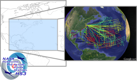
The NASA Global Hydrology Resource Center (GHRC) DAAC published the Hurricane and Severe Storm Sentinel (HS3) Cooperative Institute for Meteorological Satellite Studies (CIMSS) Cloud Top Height. This dataset contains could top height images obtained from infrared observations of the 15th Geostationary Operational Environmental Satellite (GOES-15) and the 10th Meteorological Satellite (METEOSAT-10) using the Algorithm Working Group (AWG) Cloud Height Algorithm (ACHA) for the Hurricane and Severe Storm sentinel (HS3) field campaign.
HS3 SHIPS Intensity Published
GHRC Preservation Documents
Introduction & Background
NASA scientific mission data are valuable resources that need to be preserved for the benefit of future generations. Dataset Preservation means to retain and provide easy access to the background information and knowledge used to create the data being preserved.
HS3 Field Campaign Micro Article published
 The NASA Global Hydrology Resource Center (GHRC) DAAC has published its first Field Campaign Micro Article. This Micro Article features the Hurricane and Severe Storm Sentinel (HS3) Field campaign.
GHRC Presents to UI/UX ESDSWG Monthly Meeting
On Monday, 5/7/2018, Deborah Smith and Tammy Smith of GHRC presented the GHRC data recipes and micro articles, online content available to users that connect information and data. They described the design process used to develop new types of micro articles and the iterative process that occurs between designer and outreach team members.
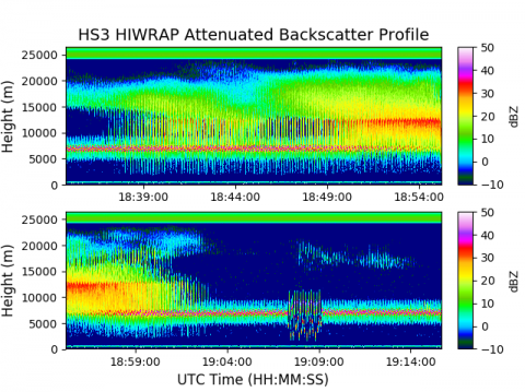
New HS3 HIWRAP Data Recipe published
GHRC data and processes from HS3 mission implemented as first Cumulus use case
![]()
![]()
GHRC DAAC represented at ESDIS Cumulus prototype meeting