Investigation of Microphysics and Precipitation for Atlantic Coast-Threatening Snowstorms (IMPACTS) Field Campaign
 
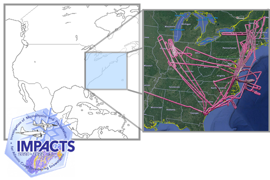
The Investigation of Microphysics and Precipitation for Atlantic Coast-Threatening Snowstorms (IMPACTS), funded by NASA’s Earth Venture program, is the first comprehensive study of East Coast snowstorms in 30 years. IMPACTS will fly a complementary suite of remote sensing and in-situ instruments for three 6-week deployments (2020-2022) on NASA’s ER-2 high-altitude aircraft and P-3 cloud-sampling aircraft. The first deployment began on January 17, 2020 and ended on March 1, 2020. IMPACTS samples U.S. East Coast winter storms from advanced radar, LiDAR, and microwave radiometer remote sensing instruments on the ER-2 and state-of-the-art microphysics probes and dropsonde capabilities on the P-3, augmented by ground-based radar and rawinsonde data, multiple NASA and NOAA satellites (including GPM, GOES-16, and the Joint Polar Satellite System (JPSS)), and computer simulations. 
 
Note: This micro article will be periodically updated as GHRC publishes more data and as new flights and IMPACTS publications occur.

Scientific Objectives

The primary objectives of IMPACTS included:

  • Provide observations critical to understanding the mechanisms of snowband formation, organization, and evolution
  • Examine how the microphysical characteristics and likely growth mechanisms of snow particles vary across snowbands
  • Improve snowfall remote sensing interpretation and modeling to significantly advance prediction capabilities
 
IMPACTS Coverage Map
Spatial Coverage
[N: 48, W: -90, E: -65, S: 32] degrees
Time Range
mid-January through February 2020-2022
PHENOMENA STUDIED
Snow Storms
Snow Microphysics

Instruments Used

Multiple instruments were utilized during the IMPACTS field campaign to sample disruptive East Coast US snowfall and winter storms. The IMPACTS airborne instrument suite combines advanced radar, lidar, and microwave radiometer remote sensing instruments on the ER-2 with state-of-the-art microphysics probes and dropsonde capabilities on the P-3. The instruments on the ER-2 include the Cloud Radar System (CRS), the High-altitude Imaging Wind & Rain Airborne Profiler (HIWRAP), the ER-2 X-Band Doppler Radar (EXRAD), the Conical Scanning Millimeter-wave Imaging Radiometer (CoSMIR), the Advanced Microwave Precipitation Radiometer (AMPR), and the Cloud Physics Lidar (CPL). The instruments on the P-3 include the Cloud-Droplet Probe (CDP), the Cloud, Aerosol and Precipitation Spectrometer (CAPS), the 2D-S Probe (2D-S), the High Volume Precipitation Sampler-3 (HVPS-3), the Nevzorov Probe (Nevzorov), the King Probe (King), the Hawkeye Probe (Hawkeye), the Rosemount Icing Probe (RICE),  the Water Isotope System for Precipitation and Entrainment Research (WISPER), the Turbulent Air Motion Measurement System (TAMMS), the Advanced Vertical Atmospheric Profiling System (AVAPS), and the Particle Habit Imaging and Polar Scattering probe (PHIPS). 
 
Ground-based instruments include radars, rawinsondes, ceilometers, and Microwave Radiometer (MWR).
 
IMPACTS Instruments
 
 
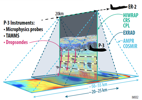
IMPACTS uses coordinated remote-sensing ER-2 and in-situ sampling P-3 flights to study the structure, dynamics, and microphysical characteristics of banded structures in winter storms. Merging ER-2 multi-sensor data (CPL, HIWRAP, and AMPR, shown above) enables advanced retrievals of microphysical properties of snowbands. (Source: Earth Science Project Office IMPACTS webpage)
PLATFORM TYPE PLATFORM RELEVANT INSTRUMENT DATASETS HOW ARE THE DATA USED?

Airborne

NASA ER-2

AMPR

CPL

CRS

CoSMIR

EXRAD

HIWRAP

LIP

data
Advanced Microwave Precipitation Radiometer (AMPR) IMPACTS
 
Cloud Physics LiDAR (CPL) IMPACTS
 
Cloud Radar System (CRS) IMPACTS
 
Conical Scanning Millimeter-wave Imaging Radiometer (CoSMIR) IMPACTS
 
ER-2 X-Band Doppler Radar (EXRAD) IMPACTS
 
ER-2 Navigation Data IMPACTS
 
High Altitude Imaging Wind and Rain Airborne Profiler (HIWRAP) IMPACTS
 
Lightning Instrument Package (LIP) IMPACTS


Radar reflectivity

Doppler velocity

Wind

Brightness Temperature

Precipitation

Water vapor

Clouds

Aerosols

Optical depth

Particle size distribution

Particle concentration

NASA P-3

CDP

CAPS

2D-S

HVPS-3

Nevzorov

King

Hawkeye

RICE

WISPER

TAMMS

AVAPS

PHIPS

data
Advanced Vertical Atmospheric Profiling System Dropsondes (AVAPS) IMPACTS
 
NCAR Particle Probes IMPACTS
 
P-3 Meteorological and Navigation Data IMPACTS
 
Particle Habit Imaging and Polar Scattering Probe (PHIPS) IMPACTS
 
Turbulent Air Motion Measurement System (TAMMS) IMPACTS
 
UND Cloud Microphysics IMPACTS
 
Water Isotope System for Precipitation and Entrainment Research (WISPER) IMPACTS
 

data

Ground  based

Ground based

Radars

Rawinsondes

Ceilometers

Disdrometers

MRR

MWR

data
Automated Surface Observing System (ASOS) IMPACTS
 
Autonomous Parsivel Unit (APU) IMPACTS
 
KAKQ NEXRAD IMPACTS
 
KBGM NEXRAD IMPACTS
 
KBOX NEXRAD IMPACTS
 
KBUF NEXRAD IMPACTS
 
KCCX NEXRAD IMPACTS
 
KCLE NEXRAD IMPACTS
 
KCXX NEXRAD IMPACTS
 
KDIX NEXRAD IMPACTS
 
KDOX NEXRAD IMPACTS
 
KDTX NEXRAD IMPACTS
 
KDVN NEXRAD IMPACTS
 
KENX NEXRAD IMPACTS
 
KFCX NEXRAD IMPACTS
 
KGRB NEXRAD IMPACTS
 
KGRR NEXRAD IMPACTS
 
KGYX NEXRAD IMPACTS
 
KILN NEXRAD IMPACTS
 
KILX NEXRAD IMPACTS
 
KIND NEXRAD IMPACTS
 
KIWX NEXRAD IMPACTS
 
KJKL NEXRAD IMPACTS
 
KLOT NEXRAD IMPACTS
 
KLWX NEXRAD IMPACTS
 
KMHX NEXRAD IMPACTS
 
KMKX NEXRAD IMPACTS
 
KOKX NEXRAD IMPACTS
 
KPBZ NEXRAD IMPACTS
 
KRAX NEXRAD IMPACTS
 
KRLX NEXRAD IMPACTS
 
KTYX NEXRAD IMPACTS
 
KVWX NEXRAD IMPACTS
 
Millersville University Upper Air Radiosondes IMPACTS
 
Mission Reports IMPACTS
 
Mobile UIUC Soundings IMPACTS
 
Multi-Radar/Multi-Sensor (MRMS) Precipitation Reanalysis for Satellite Validation Product IMPACTS
 
NASA S-Band Dual Polarimetric Doppler Radar (NPOL) IMPACTS
 
NCSU Soundings IMPACTS
 
New York State Mesonet IMPACTS
 
NEXRAD Mosaic East IMPACTS
 
NEXRAD Mosaic Midwest IMPACTS
 
NOAA Soundings IMPACTS
 
SBU Ceilometers IMPACTS
 
SBU Doppler LiDAR IMPACTS
 
SBU Ka-band Scanning Polarimetric Radar (KASPR) IMPACTS
 
SBU Meteorological Station IMPACTS
 
SBU Micro Rain Radar 2 (MRR2) IMPACTS
 
SBU Parsivel IMPACTS
 
SBU Pluvio Precipitation Gauge IMPACTS
 
SBU Soundings IMPACTS
 
Two-Dimensional Video Disdrometer (2DVD) IMPACTS
 
UAlbany Micro Rain Radar 2 (MRR2) IMPACTS
 
UAlbany Parsivel IMPACTS
 
Weather Research and Forecasting IMPACTS


Radar reflectivity

Doppler velocity

Atmospheric pressure, temperature, water vapor, and winds

Spaceborne

Satellite

GPM

GOES-16

GOES IMPACTS

Visible wavelengths

Infrared wavelengths

Visible radiance

Infrared radiance
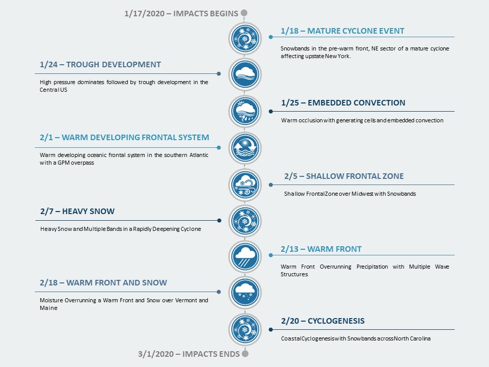
 

Events of Interest

This section highlights events within the field campaign of particular scientific interest.

IMPACTS Timeline

Major Findings

Updates will be made to this micro article throughout the field campaign.

Related Publication(s)
Abdelmonem, A., Schnaiter, M., Amsler, P., Hesse, E., Meyer, J., and Leisner, T. (2011). First correlated measurements of the shape and light scattering properties of cloud particles using the new Particle Habit Imaging and Polar Scattering (PHIPS) probe, Atmos. Meas. Tech., 4, 2125–2142, https://doi.org/10.5194/amt-4-2125-2011
 
Barrick, J. D. W., J. A. Ritter, C. E. Watson, M. W. Wynkoop, J. K. Quinn, and D. R. Norfolk (1996). Calibration of NASA turbulent air motion measurement system. NASA Tech. Pap. TP-310, NASA, Washington, D. C., https://ntrs.nasa.gov/archive/nasa/casi.ntrs.nasa.gov/19970010469.pdf
 
Battaglia, A., Mroz, K., Lang, T., Tridon, F., Tanelli, S., Tian, L., & Heymsfield, G. M. (2016). Using a multiwavelength suite of microwave instruments to investigate the microphysical structure of deep convective cores. J. Geophys. Res. Atmos., 121, 9356–9381, https://doi.org/10.1002/2016JD025269
 
Biswas, S., T. Lang, D. Duncan, and C. Kummerow (2017). Polarization deconvolution and geophysical retrieval from a dual-pol, cross-track scanning microwave radiometer (AMPR) during OLYMPEX/RADEX. 2017 Fall Meeting, American Geophysical Union, New Orleans, LA. https://ntrs.nasa.gov/archive/nasa/casi.ntrs.nasa.gov/20170012192.pdf
 
Brown, E. N., C. A. Friehe, and D. H. Lenschow (1983). The use of pressure fluctuations on the nose of an aircraft for measuring air motion. J. Climate Appl. Meteor., 22, 171–180, https://doi.org/10.1175/1520-0450(1983)022<0171:TUOPFO>2.0.CO;2
 
Cober, S.G., G.A. Isaac, and A.V. Korolev (2001). Assessing the Rosemount Icing Detector with In Situ Measurements. J. Atmos. Oceanic Technol., 18, 515–528, https://doi.org/10.1175/1520-0426(2001)018<0515:ATRIDW>2.0.CO;2
 
Delene, D. (2011). Airborne data processing and analysis software package. Earth Sci. Inform., 4, 29-44. https://doi.org/10.1007/s12145-010-0061-4.
 
Faber, S, J.R. French, and R. Jackson (2018). Laboratory and in-flight evaluation of measurement uncertainties from a commercial Cloud Droplet Probe (CDP). Atmos. Meas. Tech., 11, 3645-3659, https://doi.org/10.5194/amt-11-3645-2018
 
Field, P. R., A. J. Heymsfield, and A. Bansemer (2006). Shattering and particle interarrival times measured by optical array probes in ice clouds. J. Atmos. Ocean. Technol., 23, 1357–1371, https://doi.org/10.1175/JTECH1922.1
 
Grecu M, L. Tian, G. M. Heymsfield, A. Tokay, W. S. Olson, A. J. Heymsfield, and A. Bansemer (2018). Non-parametric methodology to estimate snow from multiple frequency radar reflectivity observations. J. Appl. Meteor. Clim., 57 (11): 2605–2622, https://doi.org/10.1175/JAMC-D-18-0036.1
 
Grecu, M., W. Olson, S. Munchak, S. Ringerud, L. Liao, Z. Haddad, B. Kelley, and S. McLaughlin (2016). The GPM combined algorithm. J. Atmos. Oceanic Tech., 33, 2225-2245, https://doi.org/10.1175/JTECH-D-16-0019.1
 
Grecu, M., L. Tian, W. S. Olson, and S. Tanelli (2011). A robust dual-frequency radar profiling algorithm. J. Appl. Meteor. Climatol., 50, 1543–1557, https://doi.org/10.1175/2011JAMC2655.1
 
Guimond, S.R., L. Tian, G.M. Heymsfield and S.J. Frasier (2014). Wind retrieval algorithms for the IWRAP and HIWRAP airborne Doppler radars with applications to hurricanes. J. Atmos. Oceanic Technol., 31, 1189-1215, https://doi.org/10.1175/JTECH-D-13-00140.1
 
Gurganus, C. and Lawson, P. (2018). Laboratory and flight tests of 2D imaging probes: Toward a better understanding of instrument performance and the impact on archived data, J. Atmos. Ocean. Tech., 35, 7, 1533–1553, https://doi.org/10.1175/JTECH-D-17-0202.1
 
Heymsfield, G. M., L. Tian, L. Li, M. McLinden, and J. I. Cervantes (2013). Airborne radar observations of severe hailstorms: Implications for future spaceborne radar. J. of Appl. Meteor. and Clim., 52, 1851-1867, https://doi.org/10.1175/JAMC-D-12-0144.1
 
Heymsfield, G. M., S. Bidwell, I. J. Caylor, S. Ameen, S. Nicholson, W. Boncyk, L. Miller, D. Vandemark, P. E. Racette, and L. R. Dod (1996). The EDOP radar system on the high-altitude NASA ER-2 aircraft. J. Atmos. Oceanic Tech., 13, 795-809, https://doi.org/10.1175/1520-0426(1996)013<0795:TERSOT>2.0.CO;2
 
Hlavka, D. L., J. E. Yorks, S. A. Young, M. A. Vaughan, R. E. Kuehn, M. J. McGill, and S. D. Rodier (2012). Airborne validation of cirrus cloud properties derived from CALIPSO lidar measurements: Optical properties, J. Geophys. Res., 117, D09207, https://doi.org/10.1029/2011JD017053
 
Korolev, A. V., Kuznetsov, S. V., Makarov, Y. E., and Novikov, V. S. (2019) Evaluation of measurements of particle size and sample area. Atmos. Meas. Tech., 12, 3067–3079, https://doi.org/10.5194/amt-12-3067-2019
 
Korolev, A.V., E.F. Emery, J.W. Strapp, S.G. Cober, and G.A. Isaac (2013). Quantification of the effects of shattering on airborne ice particle measurements. J. Atmos. Oceanic Technol., 30, 2527–2553, https://doi.org/10.1175/JTECH-D-13-00115.1
 
Kroodsma, R. A., M. A. Fritts, J. F. Lucey, M. R. Schwaller, T. J. Ames, C. M. Cooke, and L. M. Hilliard (2019). CoSMIR performance during the GPM OLYMPEX campaign. IEEE Trans. Geosci. Remote Sens., https://doi.org/10.1109/TGRS.2019.2906039
 
Lance, S., Brock, C. A., Rogers, D., and Gordon, J. A. (2010). Water droplet calibration of the Cloud Droplet Probe (CDP) and in-flight performance in liquid, ice and mixed-phase clouds during ARCPAC. Atmos. Meas. Tech., 3, 1683–1706, https://doi.org/10.5194/amt-3-1683-2010
 
Lenschow, D.H. and B.B. Stankov (1986). Length Scales in the Convective Boundary Layer. J. Atmos. Sci., 43, 1198–1209, https://doi.org/10.1175/1520-0469(1986)043<1198:LSITCB>2.0.CO;2
 
Leppert, K. D., II, and D. J. Cecil (2015). Signatures of hydrometeor species from airborne passive microwave data for frequencies 10–183 GHz. J. Appl. Meteor. Climatol., 54, 1313–1334, https://doi.org/10.1175/JAMC-D-14-0145.1
 
Li, L., G. Heymsfield, J. Carswell, D. Schaubert, M. McLinden, J. Creticos, M. Perrine, M. Coon, J. Cervantes, M. Vega, S. Guimond, L. Tian, and A. Emory (2016). The NASA High-Altitude Imaging Wind and Rain Airborne Profiler (HIWRAP). IEEE Trans. On Geosci. Remote Sens., 54, 298 - 310, https://doi.org/10.1109/TGRS.2015.2456501
 
Li, L., G. M. Heymsfield, P. E. Racette, L. Tian, E. Zenker (2004). A 94 GHz Cloud Radar System on a NASA High-altitude ER-2 Aircraft, J. Atmos. Oceanic Tech., 20, 1378-1388, https://doi.org/10.1175/1520-0426(2004)021<1378:AGCRSO>2.0.CO;2
 
McFarquhar, G.M., D. Baumgardner, A. Bansemer, S.J. Abel, J. Crosier, J. French, P. Rosenberg, A. Korolev, A. Schwarzoenboeck, D. Leroy, J. Um, W. Wu, A.J. Heymsfield, C. Twohy, A. Detwiler, P. Field, A. Neumann, R. Cotton, D. Axisa, and J. Dong (2017). Processing of Ice Cloud In Situ Data Collected by Bulk Water, Scattering, and Imaging Probes: Fundamentals, Uncertainties, and Efforts toward Consistency. Meteor. Monographs, 58, 11.1–11.33, https://doi.org/10.1175/AMSMONOGRAPHS-D-16-0007.1
 
McGill, M. J., M. A. Vaughan, C. R. Trepte, W. D. Hart, D. L. Hlavka, D. M. Winker, and R. Kuehn (2007). Airborne validation of spatial properties measured by the CALIPSO lidar. J. Geophys. Res., 112, https://doi.org/10.1029/2007JD008768
 
McGill, M.J., L. Li, W.D. Hart, G.M. Heymsfield, D.L. Hlavka, P.E. Racette, L. Tian, M.A. Vaughan, and D.M. Winker (2004). Combined lidar-radar remote sensing: initial results from CRYSTALFACE. J. of Geophys. Res., 109, https://doi.org/10.1029/2003JD004030
 
McGill, M.J., D.L. Hlavka, W.D. Hart, E.J. Welton, and J.R. Campbell (2003). Airborne lidar measurements of aerosol optical properties during SAFARI-2000. J. of Geophys. Res., 108, D002370,  https://doi.org/10.1029/2002JD002370
 
McGill, M. J., D. L. Hlavka, W. D. Hart, V. S. Scott, J. D. Spinhirne, and B. Schmid (2002). Cloud Physics Lidar: instrument description and initial measurement results. Appl. Optics, 41, 3725-3734, https://doi.org/10.1364/AO.41.003725
 
McLinden, M., J. Carswell, L. Li, G. Heymsfield, A. Emory, J. Cervantes, and L. Tian (2013). Utilizing versatile transmission waveforms to mitigate pulse-compression range sidelobes with the HIWRAP Radar. IEEE Geosci. Remote Sens. Lett., https://doi.org/10.1109/LGRS.2013.2241729
 
Rosenberg, P. D., Dean, A. R., Williams, P. I., Dorsey, J. R., Minikin, A., Pickering, M. A., and Petzold, A. (2012). Particle sizing calibration with refractive index correction for light scattering optical particle counters and impacts upon PCASP and CDP data collected during the Fennec campaign. Atmos. Meas. Tech., 5, 1147-1163, https://doi.org/10.5194/amt-5-1147-2012
 
Schnaiter, M., Järvinen, E., Abdelmonem, A., and Leisner, T. (2018). PHIPS-HALO: the airborne particle habit imaging and polar scattering probe – Part 2: Characterization and first results. Atmos. Meas. Tech., 11, 341–357, https://doi.org/10.5194/amt-11-341-2018
 
Sippel, J. A., F. Zhang, Y. Weng, L. Tian, G. M. Heymsfield, and S. A. Braun (2014). Ensemble Kalman filter assimilation of HIWRAP observations of Hurricane Karl (2010) from the unmanned Global Hawk aircraft. Mon. Wea. Rev., 142, 4559-4580, https://doi.org/10.1175/MWR-D-14-00042.1
 
Spencer, R.W., R.E. Hood, F.J. Lafontaine, E.A. Smith, R. Platt, J. Galliano, V.L. Griffin, and E. Lobl (1994). High-Resolution Imaging of Rain Systems with the Advanced Microwave Precipitation Radiometer. J. Atmos. Oceanic Technol., 11, 849–857, https://doi.org/10.1175/1520-0426(1994)011<0849:HRIORS>2.0.CO;2
 
Thornhill, K. L., B. E. Anderson, J. D. W. Barrick, D. R. Bagwell, R. Friesen, and D. H. Lenschow (2003). Air motion intercomparison flights during Transport and Chemical Evolution in the Pacific (TRACE-P)/ACE-ASIA. J. Geophys. Res., 108(D20), 9001, https://doi.org/10.1029/2002JD003108
 
Tian, L., G.M. Heymsfield, A.C. Didlake, Jr., S.R. Guimond, and L. Li (2015). Velocity-azimuth display analysis of Doppler velocity for HIWRAP. J. Appl. Meteor., 54, 1792 - 1808, https://doi.org/10.1175/JAMC-D-14-0054.1
 
Twohy, C. H., Schanot, A. J., and W. A. Cooper (1997). Measurement of Condensed Water Content in Liquid and Ice Clouds Using an Airborne Counterflow Virtual Impactor. J. Atmos. Ocean. Tech. 14, 197-202, https://doi.org/10.1175/1520-0426(1997)014<0197:MOCWCI>2.0.CO;2
 
Wang, J. R., P. E. Racette, J. R. E. Piepmeier, B. Monosmith and W. Manning (2007). Airborne CoSMIR observations between 50 and 183 GHz over snow-covered Sierra Mountains. IEEE Trans. on Geosci. and Remote Sens., 45, 55-61, https://doi.org/10.1109/TGRS.2006.885410
 
Wang, J. R, G. M Skofronick-Jackson, M. R. Schwaller, C. M. Johnson, W. B. Monosmith, and Z. Zhang (2013). Observations of storm signatures by the recently modified conical scanning millimeter-wave imaging radiometer. IEEE Trans. Geosci. Remote Sens, 51(1), 411-424, https://doi.org/10.1109/TGRS.2012.2200690
 
Yorks, J. E., D. L. Hlavka, M. A. Vaughan, M. J. McGill, W. D. Hart, S. Rodier, and R. Kuehn (2011a). Airborne validation of cirrus cloud properties derived from CALIPSO lidar measurements: Spatial properties. J. Geophys. Res., 116, D19207, https://doi.org/10.1029/2011JD015942
 
Yorks, J. E., M. McGill, D. Hlavka and W. Hart (2011b). Statistics of Cloud Optical Properties from Airborne Lidar Measurements. J. Atmos. Oceanic Technol., 28, 869-883, https://doi.org/10.1175/2011JTECHA1507.1
 
Reference Source(s)
DATE UPDATED
Nov 6th, 2023
AUTHOR(S)
Lucy Wang
MICRO ARTICLE TYPE
Field Campaign

Have you used our data? Register for updates