Dr. Sara Graves, the Director of UAH Information Technology & Systems Center (ITSC), which jointly manages GHRC with NASA's Marshall Space Flight Center (MSFC), attended a meeting of the Climate Change Science Institute (CCSI) Science Advisory Board (SAB) at Oak Ridge National Laboratory on March 5-7. The ORNL DAAC is one of the key data centers in the CCSI.
GHRC News
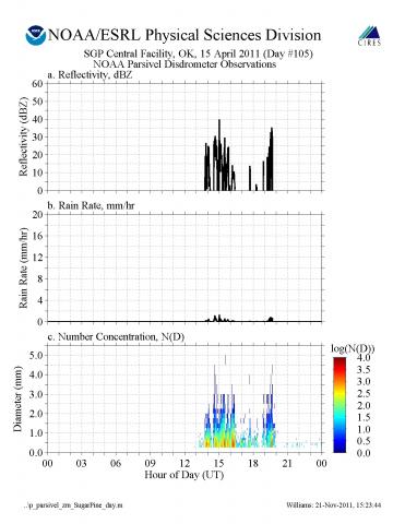 The GPM Ground Validation NOAA Parsivel MC3E data collected during the Midlatitude Continental Convective Clouds Experiment (MC3E) experiment in central Oklahoma contains moment data (reflectivity and rain rate estimates) or raindrop number concentration estimates. This data provided a reference reflectivity to calibrate the S-band profiler during the experiment. This dataset is available to the public. The raw data files for this dataset were archived as GPM Ground Validation NOAA Parsivel Raw Data MC3E by request of the Principal Investigator. Since the processed data is available as the GPM Ground Validation NOAA Parsivel MC3E dataset, the raw data will only be distributed by approval of the Principal Investigator.
 GHRC has published the GPM Ground Validation NOAA UHF 449 Profiler Raw Data SPC dataset. Using a phased array antenna configured to only point in the vertical direction, during MC3E the 449 MHz profiler measured the vertical air motion from approximately 200 to 2000 meters above the ground when precipitation passed over the profiler site. The original SPC format requires specialized commercial read software. The companion GPM Ground Validation NOAA UHF 449 Profiler MC3E dataset, a netCDF version, contains the exact same raw data values. Additionally this dataset has been recently updated to include processed data and available browse.
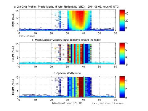 The full suite of S-band profiler datasets from the GPM Ground Validation Midlatitude Continental Convective Clouds Experiment (MC3E) is now available:
GPM Ground Validation NOAA S-Band Profiler Minute Data MC3E
GPM Ground Validation NOAA S-Band Profiler Raw Data SPC format MC3E
GPM Ground Validation NOAA S-Band Profiler Raw Data netCDF format MC3E
GPM Ground Validation NOAA S-Band Profiler Original Dwell Data MC3E
Note that the Raw profiler data is available in two formats. The original SPC format requires specialized commercial software. The netCDF version contains the same data values and is compatible with the other datasets in the collection. The S-band profiler operates at 2.8 GHz, points vertically, and measures the backscattered power from raindrops and ice particles as precipitating cloud systems pass overhead. Operating between the precipitation (full-power) and attenuated (low-power) modes, the profiler alternated between modes collecting either 7 or 9 consecutive precipitation mode profiles separated by 1 attenuated mode profile. Both modes processed radar pulses collected during a 7-second dwell before calculating the Doppler velocity spectra at each radar range gate that were separated by 60-meters in the vertical. The Original Dwell and Minute datasets contain moment, pop spectra and calibrated spectra files.
Find all the data from MC3E here.
These data sets can also be ordered from the GHRC using the Hydrologic Data search, Retrieval, and Order system (HyDRO) at https://ghrc.nsstc.nasa.gov/hydro/.
The Global Hydrology Resource Center (GHRC DAAC), a NASA Earth science data center managed by the University of Alabama in Huntsville, is pleased to announce the release of the version 7 SSMI/SSMIS F08, F10, F11, F13, F14, F15, F16, F17 Ocean Product Suite from Remote Sensing Systems (RSS) in netCDF (v4) format. These data are generated by the Distributed Information Services for Climate and Ocean Products and Visualizations for Earth Research project, (DISCOVER), PI Frank Wentz, as part of the NASA Making Earth Science Data Records for Use in Research Environments (MEaSUREs) Program.
The RSS Ocean Product Suite includes the following data products for the SSMI/SSMIS instruments on the DMSP F08, F10, F11, F13, F14, F15, F16, F17 polar orbiting satellites:
RSS SSM/I Ocean Products Grids Daily
RSS SSM/I Ocean Products Grids 3-Day Average
RSS SSM/I Ocean Products Grids Weekly Average
RSS SSM/I Ocean Products Grids Monthly Average
Detailed information for these datasets is available in the SSMI and SSMIS netCDF Data Products document.
These data sets can be ordered from the GHRC using the Hydrologic Data search, Retrieval, and Order system (HyDRO) at http://ghrc.nsstc.nasa.gov/hydro/.
