The GHRC would like to announce the availability of Open-source Project for a Network Data Access Protocol, OPeNDAP, for our entire RSS Ocean Product Suite which includes data products for the SSMI/SSMIS instruments on the DMSP F08, F10, F11, F13, F14, F15, F16, F17 polar orbiting satellites. OPeNDAP is a data transport architecture and protocol widely used by Earth scientists to access remotely distributed data. OPeNDAP includes standards for encapsulating structured data, annotating the data with attributes and adding semantics that describe the data. Data and metadata hosted through OPeNDAP is available for both interactive browser-based access by users, or through programmatic interfaces allowing applications to access distributed data resources. Access is enhanced by the ability to easily subsample, subset, aggregate and re-format data through interface options. Several existing client applications (e.g. ncBrowse, IDV, Panoply, etc) and software libraries (e.g. netCDF) readily support OPeNDAP data access.
The GHRC OPeNDAP server is available at https://ghrc.nsstc.nasa.gov/opendap/.
Please contact our User Services Office for more information.
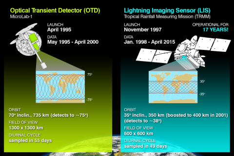 The Lightning Imaging Sensor (LIS) Science Team announces the release of version 2.3.2011 of the LIS/OTD Climatology data sets. The LIS/OTD Climatology data sets consist of gridded climatologies of total lightning flash rates seen by the spaceborne Optical Transient Detector (OTD) and Lightning Imaging Sensor (LIS). These data sets can be ordered from the GHRC DAAC using
  The Midlatitude Continental Convective Clouds Experiment (MC3E) took place in central Oklahoma April–May 2011. The experiment was a collaborative effort between the U.S. Department of Energy (DOE) Atmospheric Radiation Measurement (ARM) Climate Research Facility and the National Aeronautics and Space Administration’s (NASA) Global Precipitation Measurement (GPM) mission Ground Validation (GV) program.
 The Genesis and Rapid Intensification Processes (GRIP) experiment was a NASA Earth science field experiment conducted August 5 to September 30, 2010. The major goal was to better understand how tropical storms form and develop into major hurricanes. NASA used the DC-8 aircraft, the WB-57 aircraft and the Global Hawk Unmanned Airborne System (UAS), configured with a suite of in situ and remote sensing instruments that were used to observe and characterize the lifecycle of hurricanes. This campaign also capitalized on a number of ground networks and space-based assets, in addition to the instruments deployed on aircraft from Ft. Lauderdale, Florida (DC-8), Houston, Texas (WB-57), and NASA Dryden Flight Research Center, California (Global Hawk).