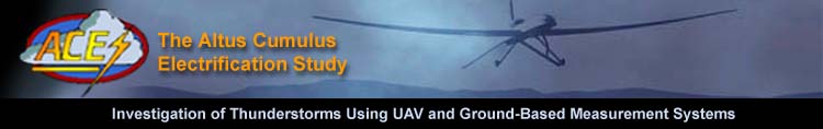
About ACES
Mission | Goals | Experiment Design
The Uninhabited Aerial Vehicle (UAV) represents an exciting new technology that can contribute in significant and unique ways to lightning and storm observations. In turn, these measurements can be linked to global scale processes (e.g., global water and energy cycle, climate variability and prediction, atmospheric chemistry) to provide an improved understanding of the total Earth system.
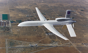
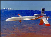 We have chosen the ALTUS II aircraft produced by General Atomic-Aeronautical Systems, Inc. (GA-ASI) for the ACES investigation. The decision to select GA-ASI as the partner was based on a number of factors including the maturity level of the ALTUS aircraft, its performance capabilities and proven flight record, and the successful integration and flight of the ACES payload on ALTUS in September 2000 under a Small Business Innovation Research (SBIR) activity with IDEA managed by one of the Co-Investigators (Co-Is), Dr. R. Goldberg.
We propose to fly ALTUS as a component of a currently funded field experiment. That field experiment, in the vicinity of NASA Kennedy Space Center (KSC), is being conducted to both validate the Tropical Rainfall Measuring Mission (TRMM) satellite measurements, and investigate lightning activity and its relationship to storm morphology. The ACES payload, already developed and flown on ALTUS, includes several electrical, magnetic, and optical sensors to remotely characterize the lightning activity and the electrical environment within and around thunderstorms.
ACES will contribute important electrical and optical measurements not available from other sources. Also, the high-altitude vantage point of the UAV observing platform offers a "cloud top" perspective especially useful for the validation study. In turn, the ground-based experiment will enable the UAV measurements to be more completely interpreted and evaluated in the context of the thunderstorm structure, evolution, and environment. Together, the UAV and ground-based observations will advance the application of global space-based lightning measurements (which are relatively easy to make) toward a better understanding of the Earth system.
Three important science objectives will be simultaneously addressed by this UAV investigation: (1) Lightning Imaging Sensor (LIS) validation, (2) lightning-storm relationships, and (3) storm electric budget. The validation effort will provide detailed characterization of lightning type, cloud-top optical energy, and power statistics that is needed to better interpret the global lightning database collected by LIS.
The ALTUS electrical measurements and ancillary ground-based measurements, from the extensive electrical and meteorological observing systems already in place at KSC, will provide detailed information on cloud properties throughout the thunderstorm life cycle. The relationships between storm electrical and kinematic properties is of particular interest as they might be used to discriminate severe from non-severe storms. How mesoscale boundaries (e.g., land/ocean) affect the development and evolution of these properties will also be explored.
There are two primary demonstration goals in the ACES project.
First, by exploiting the unique capabilities of ALTUS, we will demonstrate the utility and promise of UAV platforms for investigating thunderstorm and other weather phenomena. Slow flight speed, coupled with long endurance and high-altitude flight give the ALTUS aircraft the ability to be maintained continuously near thunderstorms for long periods of time and enable investigations to be conducted over entire storm life cycles. This overcomes the limitations of conventional aircraft that, as a result of much faster flight speeds, provide only a few brief "snapshots" of storm activity sandwiched between long intervening periods with no observations. The ALTUS, with its lower flight speed, can remain within measurement range (i.e., ~5 km) even while making turns. Presently, only the ALTUS has this combination of capabilities, essential for conducting complete storm life cycle investigations (i.e., no gaps). This demonstration goal supports a principal objective of the NRA.
A second goal, supportive of the NRA objectives, is to provide a demonstration of real-time monitoring and control of the UAV science payload and data. During flights, selected instrument output (e.g., electric field) will be sent to the ground via the ALTUS telemetry link enabling us to monitor target storms in real time. In fact, we have proposed to monitor the ambient electric field environment in real time to avoid high electric field (>25 kV/m) regions, and thus reduce to a low probability the threat of incurring a lightning strike to the aircraft. Output from the ALTUS video camera will also help monitor storm conditions in real time.
In order to achieve our objectives, we expect to use the ALTUS to observe thunderstorms during two field campaigns in the summer months of 2002 and 2003. It is anticipated that each campaign will last approximately 4 weeks with a goal of performing 8 to 10 UAV flights during each campaign. Each mission will require about 4 to 5 hours on station at altitudes from 40,000 feet to 55,000 feet. For the missions, we will need ALTUS to fly close to, and when possible, above (but never into) thunderstorms using safe operational procedures.
 We propose to base the flight operations from Patrick Air Force Base (PAFB), just south of KSC, Florida. At this location, we can take advantage of, and provide close coordination with, the measurements being acquired in central Florida in conjunction with the NASA funded Lightning Imaging Sensor Data Applications Demonstration (LISDAD) experiment. In addition, real-time access and support from ground-based systems already in place, along with standard meteorological data products, will be available to the ACES project. This KSC instrumentation, represents one of the most densely packed and unique suites of operational weather sensors available anywhere in the world. The data provided to ACES will be employed in real time to aid mission planning and execution. During post deployment, this data will aid in the science analyses and in the education and public outreach lesson plan development.
