
Lightning research has come a long way in the past few decades. We now have a better understanding of why lightning occurs and where, what lightning patterns exist over the globe, and what lightning tells us about atmospheric convection. Scientists and engineers continue to study lightning using a variety of instruments, more types than available previously and some can simultaneously measure the same events to better determine instrument measurement characteristics and capabilities.
All GHRC Micro Articles | All GHRC Data Recipes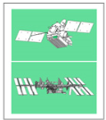 Lightning Imaging Sensor (LIS)
Summary of the LIS instrument, providing details of instrument operation, measurements, LIS data application areas and data parameter differences between ISS and TRMM platforms.
 Optical Transient Detector (OTD)
Summary of the OTD instrument, including operation, measurement details, data application areas, and relationship to the LIS instrument.
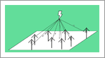 Lightning Mapping Array (LMA)
Summary of the LMA instruments, including operation, measurement details, and data application areas.
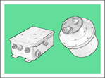 Lightning Imaging Package (LIP)
Summary of the LIP instrument, including operation, measurement details, and data application areas.
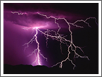 Lightning
Summary of what lightning is, why lightning occurs, where lightning occurs, how lightning is observed, and research that has been conducted on lightning.
 GOES-R Post Launch Test (PLT)
The GOES-R PLT field campaign was a collaborative mission to validate the Advanced Baseline Imager (ABI) and Geostationary Lightning Mapper (GLM) instruments aboard the GOES-R, now GOES-16, satellite.
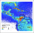
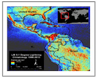
 Highlights from Cecil et. al.'s 'Gridded lightning climatology from TRMM-LIS and OTD: Dataset description' publication
Presentation of the highlights and key findings of Cecil et al.’s publication that utilized LIS/OTD data.
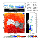 Highlights From Peterson et. al.'s 'The Properties of Optical Lightning Flashes and the Clouds They Illuminate' Publication
Summary and description of Peterson et al.’s publication utilizing TRMM LIS data available from the GHRC.
 Highlights from Albrecht et. al's 'Where Are the Lightning Hotspots on Earth?’ publication
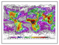
Summary and description of Albrecht et al.’s publication describing a new technique generating a series of very high resolution lightning climatology datasets from LIS data.
Tutorials or step-by-step instructions have been developed by GHRC staff to help you learn to discover, visualize and use new data, information, software and techniques. These recipes cover a variety of datasets and processing languages/software.
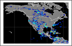
 ISS LIS Lightning Flash Location Quickview using Python 3.0 and GIS
This data recipe enables the visualization of lightning flash locations across user-selected ISS LIS swath data files. The Python code can plot the data directly, or create a CSV file for use with other software, such as ESRI ArcMap. The process can now be executed using Python 3.0.
 Using ArcGIS to Convert LIS Very High Resolution Gridded Lightning Climatology NetCDF Data to GeoTIFF
This data recipe provides a tutorial on how to bring gridded netCDF lightning data into ArcMap and create a GeoTIFF file.
ISS LIS Lightning Flash Location Quickview using Python 2.7 and GIS
This Python-based data recipe steps the user through code that compiles information from a series of ISS LIS data files in a directory and generates a gridded heat map plot of lightning flash locations and a CSV file containing the location coordinates.
 OTD Lightning Flash Location Quickview using Python 3.0 and GIS
This data recipe guides the user through a Python script that enables visualization of OTD lightning flash locations. It is designed to compile information from a series of user-selected OTD data files and generate a gridded heat map plot of lightning flash locations.
Have you used our data? Register for updates
