Using ArcGIS to Convert LIS Very High Resolution Gridded Lightning Climatology NetCDF Data to GeoTIFF Format
The Lightning Imaging Sensor (LIS) aboard the Tropical Rainfall Measuring Mission (TRMM) satellite collected over 17 years of optical lightning observations that were used to generate a Very High Resolution Lightning Climatology dataset available in gridded netCDF format. ArcGIS software does not handle all netCDF data equally due to how the geographic and other information are formatted within datafiles, thus it is best suited for gridded netCDF files. This data recipe provides a step-by-step tutorial on how to bring these gridded netCDF data into ArcMap and create a GeoTIFF file enabling GIS analysis and map making. This data recipe requires a pre-installed version of ArcMap and a downloaded file from the LIS 0.1 Degree Very High Resolution Lightning Climatology Collection available at GHRC.
| Data Recipe Type | |
|---|---|
| Data Type Conversion | |
| TYPE | ACCESS | ||
|---|---|---|---|
|
| ArcMap 10.2+ |
| Restricted, License Required |
This data recipe uses the LIS 0.1 Degree Very High Resolution Gridded Lightning Full Climatology (VHRFC) dataset. More information and additional resources about this dataset can be accessed here: http://dx.doi.org/10.5067/LIS/LIS/DATA301. To follow along with the steps below, a pre-installed version of ArcMap 10.2 or higher is required, in addition to the Spatial Analyst Extension.
Follow the steps below to convert the gridded netCDF data to raster GeoTIFF form. Please note this data recipe is compatible with the other climatology datasets that are a part of the LIS 0.1 Degree Very High resolution Gridded Lightning Climatology Data Collection including the annual, full, monthly and seasonal lightning climatologies. More information about these datasets can be found in Step 14.
To download the data needed for this data recipe, a free NASA Earthdata user account is required. If you do not have an account, you will first need to create one.
Once your account has been created, you can download the compressed netCDF file for the LIS 0.1 Degree Very High Resolution Gridded Lightning Full Climatology (VHRFC) used for this data recipe. Simply follow this link below and enter your account information, select and download the compressed netCDF file.
Once you have downloaded the data, extract/unzip the files to a folder on your computer.
Open your ArcMap Desktop application. For this tutorial, ArcMap 10.2 was used.
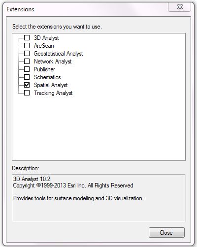
First check if the ArcMap Spatial Analyst extension is activated by selecting from the main menu bar “Customize” > “Extensions”. Check to ensure the box is selected as show below, if not, select the box next to “Spatial Analyst” and click “Close”.
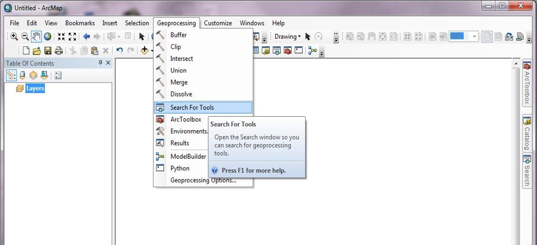
Once the necessary extension is enabled, you will then search for a tool through the search window. You can access this window by clicking on the ”Geoprocessing” option in the main menu and selecting “ Search For Tools”.
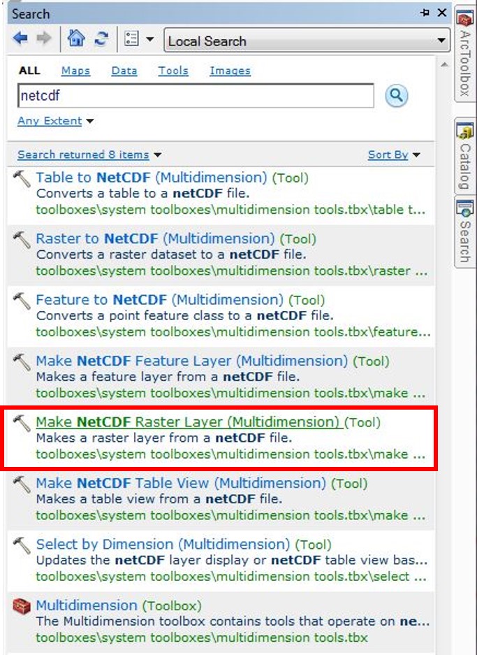
Using the search window that appears, search for the ArcMap tool “Make NetCDF to Raster Layer (Multidimension)”. You can simply enter the keyword “netcdf” and the tool will appear as a result.
To open the tool, click the tool name. A window will open displaying a series of empty fields. The first field will read “Input netCDF File”. Click the folder icon to the right of the field to navigate to the file location where the downloaded NetCDF file is saved, select the file and click “Open”.
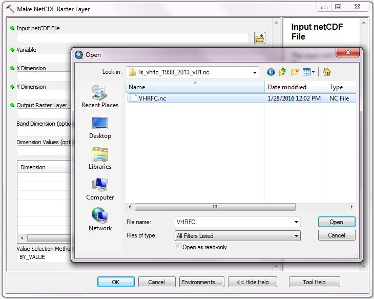
The following fields within the window will automatically populate: “Variable, X Dimension”, “Y Dimension”, and “Value Selection Method”.
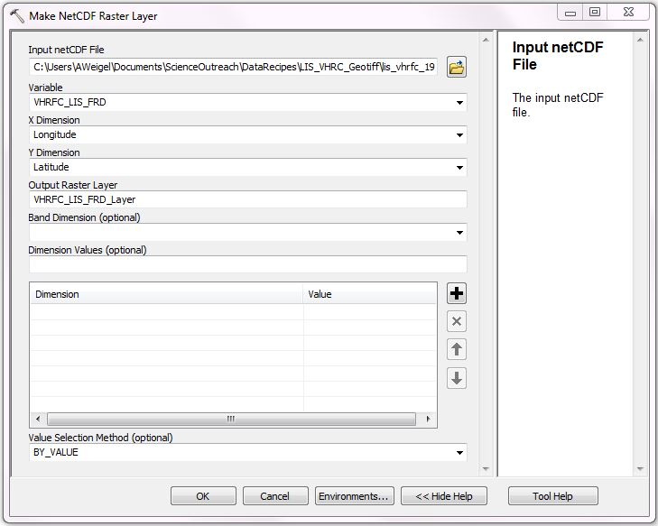
The “Variable” field will read “VHRDC_LIS_FRD”, which is the lightning flash rate density for this specific file. You may select the other variable, “VHRDC_LIS_VT”; however this is the observation view time and not the lightning information. Leave this field as is.
The Dimension fields will populate “Longitude” for the “X Dimension” and “Latitude” for the “Y Dimension”, which are correct. Leave these as is.
The “Output Raster Layer” field will generate a default name. You may change this name if you like, however, we will leave it as is for this demonstration.
The remaining optional fields can be left empty. Select “OK”.
A raster layer will be created within ArcGIS and displayed as shown below.
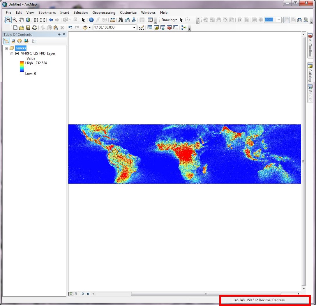
Move your cursor over the dataset. In the bottom right hand corner you will notice that the corresponding coordinates appear. These coordinates should range from 90 to -90 degrees north (top to bottom), and -180 to 180 degrees East (left to right).
The “Make NetCDF to Raster Layer” tool creates a temporary raster layer file, so it must be exported and saved as a separate GeoTIFF file. To do this, right click on the raster layer name and select “Data” > “Export Data”.
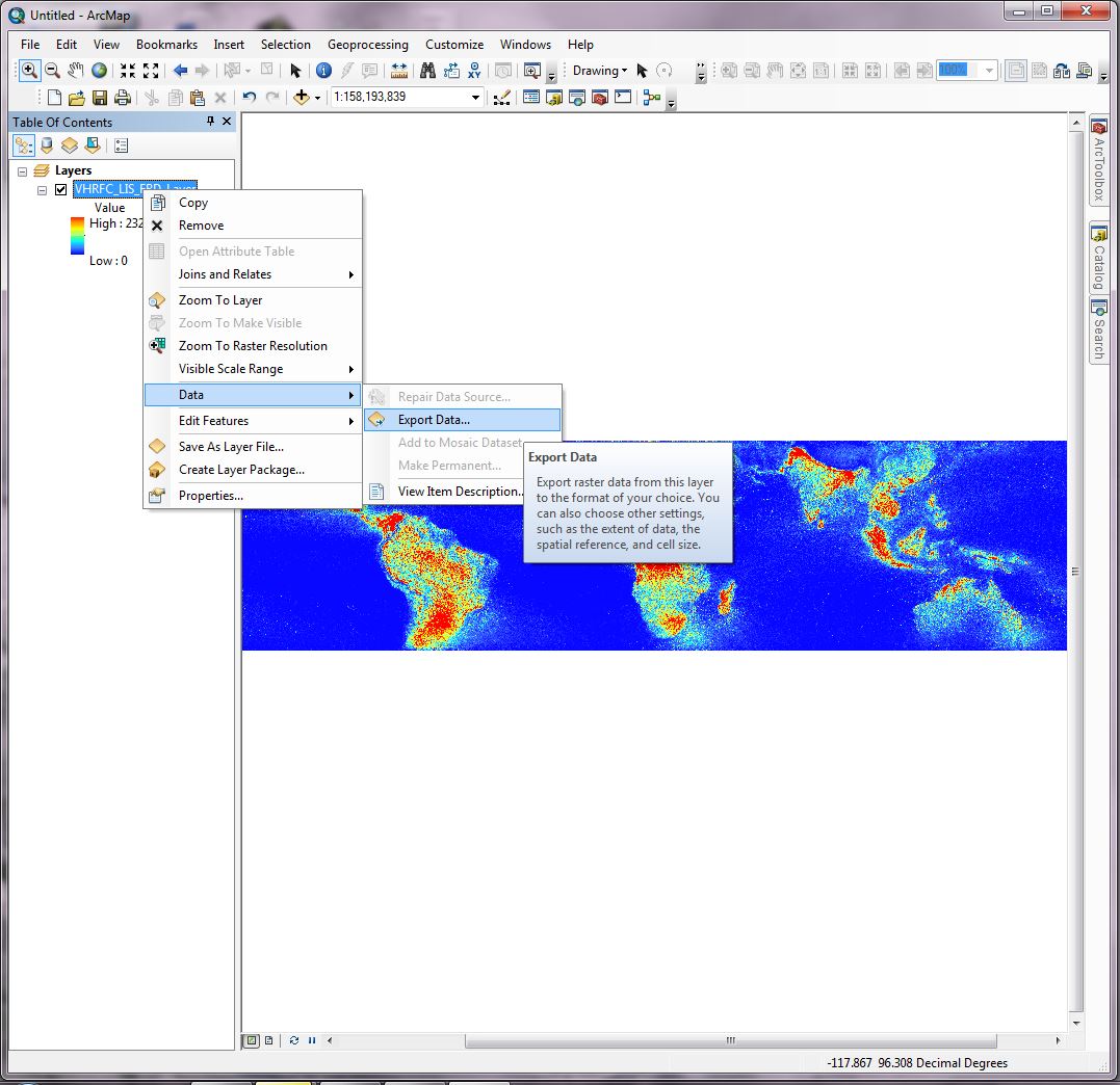
An Export Raster Data window will open. There are several fields that may be changed however, the default settings are fine. You will need to define the file “Location:” where you would like the raster saved and the “Name:” of the file. The“Format:” field will need to be set as “TIFF” to convert to GeoTIFF format.
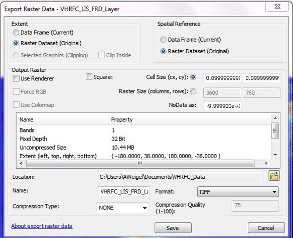
Once these fields are complete, select “Save” > “Yes”. The GeoTIFF file will automatically load into ArcGIS in grayscale. This is normal and the colors may be altered later.
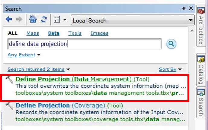
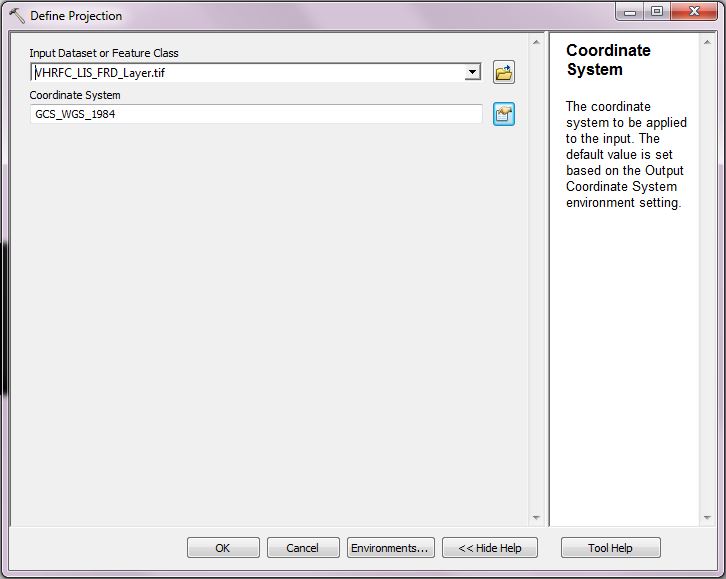
At this point, the geographic information is undefined for this data file. Return to the “Search For Tools” window and search for the “Define Projection (Data Management)” tool. Click to open.
Set the “Input Dataset or Feature Class” field to the GeoTIFF you have just created using the drop down arrow to select from the files available in ArcMap.
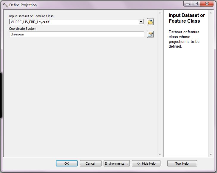
The “Coordinate System” field will read “Unknown” because the geographic information was not defined in the the original netCDF file. Many datasets are formatted using a basic latitude/longitude grid, so the projection information is not always defined in metadata, thus it is necessary to define the projection in ArcMap. A common projection used across scientific data is the World Geographic Coordinate System 1984 (WGS 1984). Because this data is formatted on a grid for most of the world we recommend using this projection for the gridded lightning climatology data.
Select the icon to the right side of the “Coordinate System” field. A “Spatial Reference Properties” window will open. For this dataset, we want to select WGS 1984. To navigate to this coordinate system, select “Geographic Coordinate Systems” > “World” > “WGS 1984”. Then click “OK”.
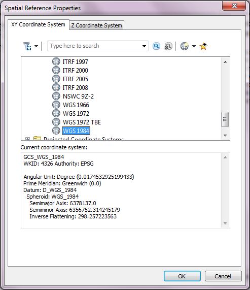
The name will automatically populate within the “Coordinate System” field. Then click “OK” to run and tool and define the coordinate system.
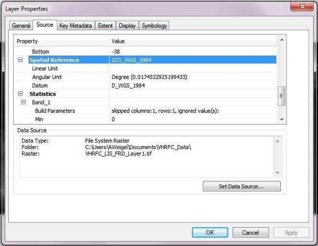
To ensure the correct coordinate system has been defined, double click the GeoTIFF layer name to open the “Layer Properties” window. Select the tab “Source” and scroll down to “Spatial Reference” where you will see that the coordinate system information has been defined and added to the data layer properties. Select “Cancel” to exit out of the window.
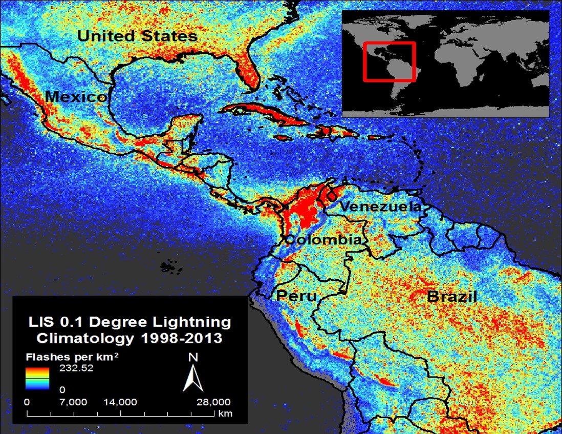
You have successfully created a raster (GeoTIFF) data file depicting the lightning flash rates that have occurred per square kilometer from 1998 to 2013 measured by TRMM LIS. This data may now be used to perform additional GIS analyses and map making.
GHRC offers four other LIS 0.1 Degree Very High Resolution Gridded Lightning Climatology datasets that may also be used with this data recipe:
LIS 0.1 Degree Very High Resolution Gridded Lightning Annual Climatology (VHRAC)
http://dx.doi.org/10.5067/LIS/LIS/DATA304
LIS 0.1 Degree Very High Resolution Gridded Lightning Diurnal Climatology (VHRDC)
http://dx.doi.org/10.5067/LIS/LIS/DATA303
LIS 0.1 Degree Very High Resolution Gridded Lightning Monthly Climatology (VHRMC)
http://dx.doi.org/10.5067/LIS/LIS/DATA302
LIS 0.1 Degree Very High Resolution Gridded Lightning Seasonal Climatology (VHRSC)
| Dataset Name | LIS 0.1 Degree Very High Resolution Gridded Lightning Full Climatology (VHRFC) |
| Platform | Tropical Rainfall Measuring Mission (TRMM) |
| Instrument | Lightning Imaging Sensor (LIS) |
| Science Parameter | Flash Rate Density |
| Format | NetCDF-4 |
| Data Information |
|
| Variable | Description | Dimension | Units | Scale Factor |
|---|---|---|---|---|
| Latitude | Latitude | 1D | degrees | None |
| Longitude | Longitude | 1D | degrees | None |
| VHRFC_LIS_FRD | Mean LIS flash rate density full climatology | 2D | flashes/km2/year | None |
| VHRC_LIS_VT | Viewtime (observation time) | 2D | seconds | None |

Oct 10th, 2017

