Since the year 2000, eastern Louisiana, coastal Mississippi, Alabama, and the western Florida panhandle have been affected by over 28 tropical storms, seven of which were hurricanes. These tropical cyclones have significantly altered normal coastal processes and characteristics in the Gulf region through sediment disturbance. In fact, tropical storm-induced sediment disturbance is a factor in four of the five Gulf of Mexico Alliance (GOMA) priority issues:
- Water quality for beaches and shellfish beds
- Wetland and coastal conservation restoration
- Characterization of Gulf habitats
- Reduction of nutrient inputs to coastal systems.
The Sediment Analysis Network for Decision Support (SANDS) project helped resolve Gulf of Mexico Alliance (GOMA) priority issues by generating decision support from MODIS and Landsat data. The Geological Survey of Alabama (GSA) and the Information Technology and Systems Center (ITSC) at The University of Alabama in Huntsville were collaborators on this NASA funded effort. The ITSC has obtained the remotely sensed data from both NASA and USGS data centers. The data sets were subset over the Northern Gulf of Mexico study region and converted to GeoTiff format for analysis by GSA.
The Landsat and MODIS data are available via the links to the left and the SANDS ftp server. GSA produced enhanced imagery such as the sample to the left that depicts suspended sediments. The analysis also revealed that oil floating on the surface can be extracted using the same technique. NASA Earth science products used in this project include:
- Landsat 7 ETM+ all bands for years 2000 through 2002
- Landsat 5 TM all bands for years 2003 through 2008
- MODIS Aqua surface reflectance bands 8 through 16
Hurricane Ivan's effect on sediment transport patterns -- before and after
Before:
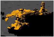
Wisps of suspended sediment extracted from Landsat 5 imagery showing normal sediment transport patterns east of Mobile Bay on September 13, 2004. These wisps correlate with sand ridges on the seafloor.
After:
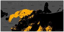
Suspended sediment data extracted from Landsat 5 imagery showing sediment transport patterns after Hurricane Ivan on September 20, 2004.
