GHRC/ITSC-Developed Tools & Technologies
The following tools and technologies have been developed at the Global Hydrometeorology Resource Center and the Information Technology and Systems Center at The University of Alabama in Huntsville.
Tutorials or step-by-step instructions have been developed by GHRC staff to help you learn to discover, visualize and use new data, information, software and techniques. These recipes cover a variety of datasets and processing languages/software.
The Field Campaign eXplorer (FCX) addresses challenges inherent with utilizing diverse field campaign datasets to improve data management and discoverability to enable scientists to rapidly collect, visualize, and analyze the data in a common framework.
FCX Tool
The Level 1 Tropical Rainfall Measuring Mission (TRMM) Tropical Cyclone Precipitation Feature (TCPF) Database provides TRMM-based tropical cyclone swath data. The TCPF Level 1 dataset marks the shift in GHRC's direction towards the new focus of hazardous weather. This tool can be used to query the TCPF database and both visualize and download data.
External Tools & Technologies
Earthdata is a tool provided by NASA for the purpose of accessing, searching, ordering, and discovering data housed in the ECHO metadata collection. Earthdata also has a tutorial video available.
Worldview shows the entire Earth as it looks "right now" - or at least as it has looked within the past few hours. Worldview supports time-critical application areas such as wildfire management, air quality measurements, and weather forecasting.
Esri's ArcGIS is a geographic information system (GIS) for working with maps and geographic information. It is used for: creating and using maps; compiling geographic data; analyzing mapped information; sharing and discovering geographic information; using maps and geographic information in a range of applications; and managing geographic information in a database.
IDL (Interactive data Language) is an analysis and visualization tool.
The Hierarchical Data Format (HDF) is a popular data format that can be used to store a variety of data "objects", such as arrays, annotations, and images. The HDF libraries, available for FORTRAN and C programmers, have been ported to a variety of platforms.
HDF is the prescribed format for standard data products that are derived from EOS missions. HDF-EOS (Hierarchical Data Format - Earth Observing System) is a self-describing file format for transfer of various types of data between different machines based upon HDF. HDF-EOS is a standard format to store data collected from EOS satellites: Terra, Aqua and Aura.
NetCDF (network Common Data Form) is an interface for array-oriented data access and a library that provides an implementation of the interface.
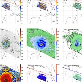
Cyclone Center is a Zooinverse citizen science project that relies on volunteers to help researchers categorize tropical cyclone imagery according to system strength, intensity, and other factors. The project uses the Dvorak technique to classify tropical cyclones that have formed since the 1970s.
