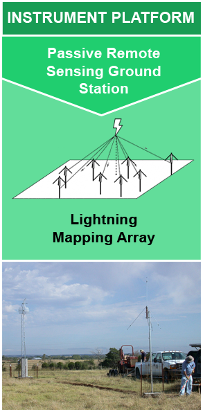
Instrument: Lightning Mapping Array (LMA)
A Lightning Mapping Array (LMA) is a network of antennas, GPS receivers, and processing systems that detect total lightning. This includes both lightning that occurs within the clouds (CC) and lightning that reaches the ground (CG); although typically not the actual point at which the flash comes to ground. The system is able to determine the location and time of lightning discharge based on the time it takes the very high frequency (VHF) signal radiated by the discharge to arrive at the various antenna stations.* The LMA VHF antennas detect the signal within a locally unused VHF telecommunications band. These antenna stations are typically placed 15 to 20 km apart over a region 60 to 80 km in diameter. Around 7 to 20 LMA antennas surround a central station that calculates the time and location of the lightning source. LMA antennas are typically placed at remote locations with minimal signal interference where they can effectively detect the lightning VHF signals.The antennas are equipped with a GPS receiver for time synchronization and wirelessly connected to the central station, permitting real-time data processing and display. Each antenna is adjusted to only capture events with a signal magnitude above a certain threshold, indicating lightning activity. When a signal is detected, the antenna station transmits the time at which it received the signal back to the central station. The LMA processing system then calculates the time, latitude, longitude, and altitude of the lightning source using the known distances between each antenna and the difference in the signal time-of-arrival at each of the VHF antennas. These antennas can detect hundreds of sources per lightning flash over a domain extending around 200 km from the central point of the antenna network. The system detects the various segments of the lightning channel as it develops, revealing the evolution of the lightning structure during discharge.
*Note: Low frequency (LF) LMA systems do exist but VHF systems are most common.
The location, time, and structure of total lightning (intra-cloud, cloud-to-cloud, & cloud-to-ground). The accuracy of measurements decreases with increasing distance from the center of the LMA antenna network.
| SPATIAL RESOLUTION | SPATIAL EXTENT | TEMPORAL RESOLUTION | ACCURACY | FREQUENCY | SAMPLING DURATION |
|---|---|---|---|---|---|
|
horizontal: approx. 6 - 12 m vertical: approx. 20 - 30 m |
~ 200 km from network center | Per lightning event | > 95% within 100 km of network | Varies | 80 - 100 µs (10 µs for detailed lightning studies) |
Chmielewski, V.C., & Bruning, E. C. (2016). Lightning Mapping Array flash detection performance with variable receiver thresholds. Journal of Geophysical Research: Atmospheres, 121, 8600-8614. https://doi.org/10.1002/2016JD025159
Goodman, S. J., Blakeslee, R., Christian, H., Koshak, W., Bailey, J., Hall, J., . . . Gatlin, P. (2004). The North Alabama Lightning Mapping Array: Recent severe storm observations and future prospects. Atmospheric Research, 76, 423-437. https://doi.org/10.1016/j.atmosres.2004.11.035
Hill, J. D., Pilkey, J., Uman, M. A., Jordan, D. M., Rison, W., Krebhiel, P. R., . . . Blakeslee, R. (2013). Correlated lightning mapping array and radar observations of the initial stages of three sequentially triggered Florida lightning discharges. Journal of Geophysical Research: Atmospheres, 118, 8460-8481. https://doi.org/10.1002/jgrd.50660
Lyu, F., Cummer, S. A., Solanki, R., Weinert, J., McTague, L., Katko, A., . . . Wang, W. (2014). A low-frequency near-field interferometric-TOA 3-D Lightning Mapping Array. Geophysical Research Letters, 41, 7777-7784. https://doi.org/10.1002/2014GL061963
Proctor, D. E. (1971). A Hyperbolic System for Obtaining VHF Radio Pictures of Lightning. Journal of Geophysical Research, 76, 1478-1489. https://doi.org/10.1029/JC076i006p01478
Proctor, D. E. (1981). VHF radio pictures of cloud flashes. Journal of Geophysical Research , 86, 4041-4071. https://doi.org/10.1029/JC086iC05p04041
The National Severe Storms Laboratory (n.d.). Research tools: Oklahoma Lightning Mapping Array. https://www.nssl.noaa.gov/tools/oklma/
Thomas, R. J., Krehbiel, P. R., Rison, W., Hunyady, S. J., Winn, W. P., Hamlin, T., & Harlin, J. (2004). Accuracy of the Lightning Mapping Array. Journal of Geophysical Research, 109, D14207. https://doi.org/10.1029/2004JD004549

Jun 25th, 2020
Instrument

