Introduction
This README file contains information about the content and structure of the ER-2 navigation files for flights in support of CAMEX-3. These data files were generated on board the ER-2, saved to disk, and downloaded post flight.
Content and structure of the NAV files
Each NAV filename has the structure: er2nav_1998.ddd_daily.tar. In its own way, the filename is a metadata tag for the data file itself, where er2nav announces that this is navigation data from the NASA ER-2 aircraft. The year (1998) and day of year (ddd) give the start date (UTC) of the mission. The data for each mission is combined in a tape archive format (tarred) file so that the ASCII text files, and the .gif image files are easily disseminated. For the following descriptions, we will use er2nav_1998.216_daily.tar as an example. Upon 'untarring' this file we find four files: 98216_flt_data.txt, 98216_switch.txt, 98216_param_01.gif, and 98216_param_02.gif. These will be detailed below.
a. 98216_flt_data.txt
This text file contains information recorded by on board navigation and data collection systems. In addition to typical navigation data (e.g. date, time, lat/lon and altitude) it contains outside meteorological parameters such as wind speed and direction and temperature. The table here shows a sample of the data from the file above, but has been edited for the sake of clarity and brevity. If you are viewing this in HTML expand the window to full screen to see the entire data line.
The first line of data decodes as follows:
NASA 806 - ER-2 tail number 806 belonging to NASA<
Flight #98-100 08/04/98/216 (GMT)- 98-101 is the NASA flight number
07/31/98- DD/MM/YY , 216 is the numeric day of the year, GMT-UTC on which the flight took off
RECORDER2 HARD DISK 8 - the recorder and disk the data was originally saved upon.
Lines 3 and 4 provide column headers (when properly aligned) for the data, while line 5 provides the units in which the data are reported. INU means Inertial Navigation Unit. The other abbreviations are self-explanatory. Time is in UTC. Note the difference between the PRESS ALT (ft) and the SAT altitude (feet) in the first data line: 68005 vs 67057. This difference is due to the method by which the altitude is determined: the pitot-static system is based upon a relationshiop between ambient pressure and altitude while the SAT altitude is determined from the GPS system. Also note that values for AIR SPD (knts) is missing for each data entry (as it so happens they are missing for the entire flight).
As these data are extensive in nature and difficult to extract to fit on one page as text, it might behoove the user to import these data into a spreadsheet. Once there you can format the cells so that the data fit to columns, then realign the column headers to reflect the pattern above.
b. 98216_switch.txt
Below are the contents of this file. Commonly called ?switchology?, this file describes information about the mission, pilot, date and time as well as on/off times for each of the switches which control the separate scientific instruments. If for example you knew that your instrument was in the ?Q-bay? and was powered through switch Q6, you would know that your instrument was powered at 16:21:25 while the aircraft was at 2534 feet.
N0804_AD.RPT
------------------------------------------------------------------------
ER-2 Nav Recorder Report
Aircraft: 806
Pilot: Porter
Date: 98-08-04
Day of year: 216
Takeoff (UTC): 16:31
Landing (UTC): 18:11
Departure airport: Dryden
Arrival airport: Dryden
Site/Objective: CAMEX
Log Number(s): 82204
Sortie Number: 98-102
Date submitted: 98-08-04
By: Sky Yarbrough
Nav recorder: NAVREC# 02
Hard drive: HD# 011
Anomalies: None Noted.
Remarks:
------------------------------------------------------------------------
DATA FILE INFORMATION:
Original filename: N0804_AD.DAT
Original size (bytes): 5,697,738
Date/Time Stamp (UTC): 98-08-04 12:16
Initial time: 15:29:48
GPS sync time: 15:32:47
1 sec gap at: 15:32:57
Last reported time: 18:19:58
Total Records: 10211
File duration 02:50:12
SWITCH ACTIVITY:
NOSE POWER : ON 16:20:51 2561 ft
LOWER QBAY POWER : ON 16:21:00 2557 ft
UPPER QBAY POWER : ON 16:21:01 2556 ft
LEFT WING POWER : ON 16:21:03 2555 ft
RIGHT WING POWER : ON 16:21:04 2554 ft
Switch Q1 : ON 16:21:21 2538 ft
Switch Q6 : ON 16:21:25 2534 ft
Switch L3 : ON 16:21:28 2530 ft
Switch R3 : ON 16:21:31 2526 ft
Switch N1 : ON 16:33:17 14809 ft
Switch N2 : ON 16:33:18 14911 ft
Switch L1 : ON 16:53:53 61666 ft
Switch R1 : ON 16:53:53 61666 ft
Switch N2 : OFF 16:54:15 61841 ft
Switch N1 : OFF 16:54:16 61851 ft
Switch N1 : ON 16:55:26 62911 ft
Switch N2 : ON 16:55:27 62926 ft
Switch L1 : OFF 16:57:56 63524 ft
Switch R2 : ON 16:59:34 65261 ft
Switch L1 : ON 17:00:05 65740 ft
Switch L1 : OFF 17:03:58 66655 ft
Switch L1 : ON 17:06:58 67530 ft
Switch L1 : OFF 17:11:01 68758 ft
LEFT WING POWER : OFF 17:11:03 68766 ft
Switch L3 : OFF 17:11:03 68766 ft
LEFT WING POWER : ON 17:11:11 68810 ft
Switch L3 : ON 17:11:11 68810 ft
Switch L1 : ON 17:11:13 68823 ft
Switch L1 : OFF 17:14:15 69368 ft
Switch R2 : OFF 17:32:33 70148 ft
Switch R1 : OFF 17:33:39 70305 ft
Switch N2 : OFF 17:56:50 20747 ft
Switch N1 : OFF 17:56:50 20747 ft
WEIGHT-ON-WHEELS (LANDING GEAR) STATUS:
216 15:29:48 Weight ON
216 16:31:06 Weight OFF
216 18:11:52 Weight ON
216 18:11:53 Weight OFF
216 18:11:54 Weight ON
End Report
c. 98216_param_01.gif, 98216_param_02.gif
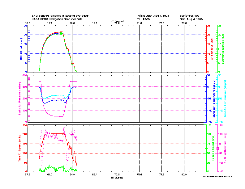
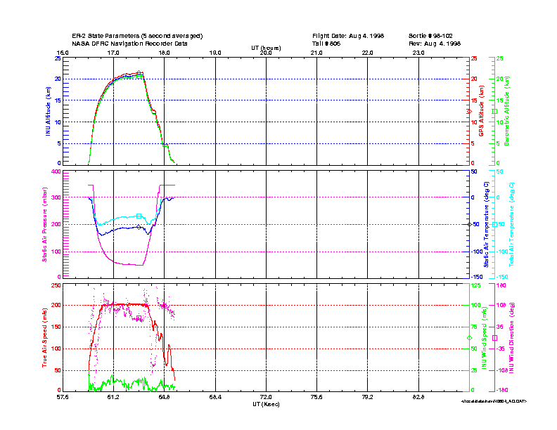
These two images graphically depict flight parameters with respect to time. These data are based upon the flight data collected in paragraph 2a above. There are two such plots, 01 and 02, each of which displays different flight parameters. Close examination will reveal that they are self-explanatory.


Contact Information
To order these data or for further information, please contact:

