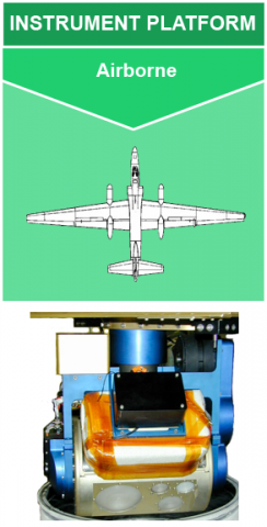
 The NASA Global Hydrology Resource Center (GHRC) DAAC published the Conical Scanning Millimeter-wave Imaging Radiometer (CoSMIR) IMPACTS dataset. This dataset consists of brightness temperature measurements collected by the Conical Scanning Millimeter-wave Imaging Radiometer (CoSMIR) flown onboard the NASA ER-2 aircraft during the Investigation of Microphysics and Precipitation for Atlantic Coast-Threatening Snowstorms (IMPACTS) field campaign. IMPACTS was a three-year sequence of winter season deployments conducted to study snowstorms over the U.S Atlantic coast. IMPACTS aimed to (1) Provide observations critical to understanding the mechanisms of snowband formation, organization, and evolution; (2) Examine how the microphysical characteristics and likely growth mechanisms of snow particles vary across snowbands; and (3) Improve snowfall remote sensing interpretation and modeling to significantly advance prediction capabilities. CoSMIR is a conical and cross-track scanning radiometer with frequencies centered at 50.3, 52.8, 89.0, 165.5, 183.31±1, 183.31±3, and 183.31±7 GHz. The brightness temperature data from CoSMIR are available from January 15 through February 27, 2020 in netCDF-4 format. It should be noted that the ER-2 aircraft did not operate each day of the campaign, therefore CoSMIR data are only available for aircraft flight days.
GHRC Published CoSMIR IMPACTS Dataset
The NASA Global Hydrology Resource Center (GHRC) DAAC published the Conical Scanning Millimeter-wave Imaging Radiometer (CoSMIR) IMPACTS dataset. This dataset consists of brightness temperature measurements collected by the Conical Scanning Millimeter-wave Imaging Radiometer (CoSMIR) flown onboard the NASA ER-2 aircraft during the Investigation of Microphysics and Precipitation for Atlantic Coast-Threatening Snowstorms (IMPACTS) field campaign. IMPACTS was a three-year sequence of winter season deployments conducted to study snowstorms over the U.S Atlantic coast. IMPACTS aimed to (1) Provide observations critical to understanding the mechanisms of snowband formation, organization, and evolution; (2) Examine how the microphysical characteristics and likely growth mechanisms of snow particles vary across snowbands; and (3) Improve snowfall remote sensing interpretation and modeling to significantly advance prediction capabilities. CoSMIR is a conical and cross-track scanning radiometer with frequencies centered at 50.3, 52.8, 89.0, 165.5, 183.31±1, 183.31±3, and 183.31±7 GHz. The brightness temperature data from CoSMIR are available from January 15 through February 27, 2020 in netCDF-4 format. It should be noted that the ER-2 aircraft did not operate each day of the campaign, therefore CoSMIR data are only available for aircraft flight days.