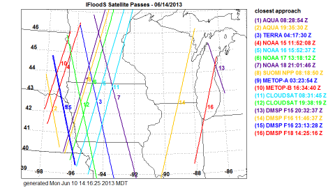
 The NASA Global Hydrology Resource Center (GHRC) DAAC published the GPM Ground Validation Satellite Overpasses IFloodS dataset. This dataset contains plots of satellite overpass paths centered over eastern Iowa during the Global Precipitation Measurement (GPM) mission Iowa Flood Studies (IFloodS) field campaign. The campaign aimed to collect detailed measurements of precipitation at the Earth’s surface while simultaneously collecting data from satellites passing overhead. This dataset consists of paths for Earth observation satellites operating during the campaign: NASA’s AQUA, TERRA, and CloudSat satellites; NOAA’s NOAA-15, NOAA-16, NOAA-17, NOAA-18, and Suomi NPP satellites; Europe’s MetOp-A and MetOp-B satellites, and DMSP’s F-15, F-16, F-17, and F-18 satellites. The satellite overpasses are provided as PNG plot images and as KML files with which the paths can be imported and viewed in Google Earth.
GHRC Published GPM GV Satellite Overpasses IFloodS
The NASA Global Hydrology Resource Center (GHRC) DAAC published the GPM Ground Validation Satellite Overpasses IFloodS dataset. This dataset contains plots of satellite overpass paths centered over eastern Iowa during the Global Precipitation Measurement (GPM) mission Iowa Flood Studies (IFloodS) field campaign. The campaign aimed to collect detailed measurements of precipitation at the Earth’s surface while simultaneously collecting data from satellites passing overhead. This dataset consists of paths for Earth observation satellites operating during the campaign: NASA’s AQUA, TERRA, and CloudSat satellites; NOAA’s NOAA-15, NOAA-16, NOAA-17, NOAA-18, and Suomi NPP satellites; Europe’s MetOp-A and MetOp-B satellites, and DMSP’s F-15, F-16, F-17, and F-18 satellites. The satellite overpasses are provided as PNG plot images and as KML files with which the paths can be imported and viewed in Google Earth.