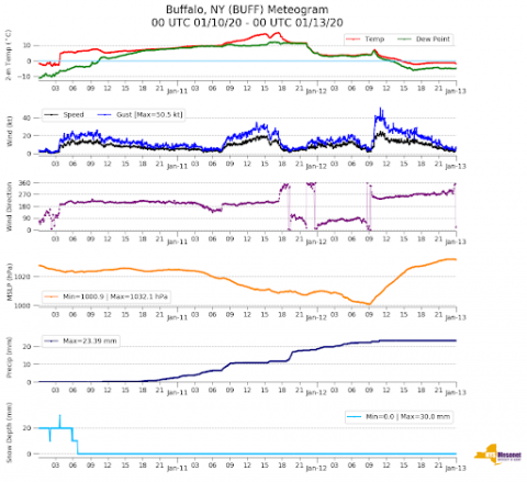
 The NASA Global Hydrology Resource Center (GHRC) DAAC published the New York State Mesonet IMPACTS dataset. This dataset is a browse-only dataset and consists of temperature, wind, wind direction, mean sea level pressure, precipitation, and snow depth measurements, as well as profiler Doppler LiDAR and Microwave Radiometer (MWR) measurements from the New York State Mesonet network during the Investigation of Microphysics and Precipitation for Atlantic Coast-Threatening Snowstorms (IMPACTS) field campaign, a three-year sequence of winter season deployments conducted to study snowstorms over the U.S. Atlantic coast. IMPACTS aimed to (1) Provide observations critical to understanding the mechanisms of snowband formation, organization, and evolution; (2) Examine how the microphysical characteristics and likely growth mechanisms of snow particles vary across snowbands; and (3) Improve snowfall remote sensing interpretation and modeling to significantly advance prediction capabilities. The Mesonet network consists of ground weather stations, LiDAR profilers, and microwave radiometer (MWR) profilers. These browse files are available from January 3 through March 1, 2020 in PNG format. It should be noted that the NY Mesonet IMPACTS data are password protected and available via an NCAR server at https://data.eol.ucar.edu/dataset/list?project=602&children=project, as well as, available at https://doi.org/10.26023/Z4ZB-4QWD-3X05 (standard data) and https://doi.org/10.26023/AEQQ-1VH5-0B13 (profiler data).
 GHRC Published NYS Mesonet IMPACTS Dataset
The NASA Global Hydrology Resource Center (GHRC) DAAC published the New York State Mesonet IMPACTS dataset. This dataset is a browse-only dataset and consists of temperature, wind, wind direction, mean sea level pressure, precipitation, and snow depth measurements, as well as profiler Doppler LiDAR and Microwave Radiometer (MWR) measurements from the New York State Mesonet network during the Investigation of Microphysics and Precipitation for Atlantic Coast-Threatening Snowstorms (IMPACTS) field campaign, a three-year sequence of winter season deployments conducted to study snowstorms over the U.S. Atlantic coast. IMPACTS aimed to (1) Provide observations critical to understanding the mechanisms of snowband formation, organization, and evolution; (2) Examine how the microphysical characteristics and likely growth mechanisms of snow particles vary across snowbands; and (3) Improve snowfall remote sensing interpretation and modeling to significantly advance prediction capabilities. The Mesonet network consists of ground weather stations, LiDAR profilers, and microwave radiometer (MWR) profilers. These browse files are available from January 3 through March 1, 2020 in PNG format. It should be noted that the NY Mesonet IMPACTS data are password protected and available via an NCAR server at https://data.eol.ucar.edu/dataset/list?project=602&children=project, as well as, available at https://doi.org/10.26023/Z4ZB-4QWD-3X05 (standard data) and https://doi.org/10.26023/AEQQ-1VH5-0B13 (profiler data). 