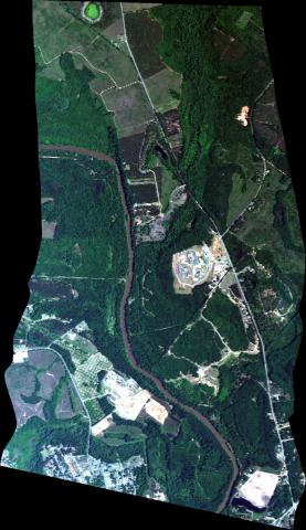
 The NASA Global Hydrology Resource Center (GHRC) DAAC published the GOES-R PLT Airborne Visible/Infrared Imaging Spectrometer (AVIRIS) dataset. This dataset consists of radiance, reflectance, water phase, and navigation data delivered by the Airborne Visible/Infrared Imaging Spectrometer (AVIRIS) flown aboard the NASA ER-2 high-altitude aircraft during the GOES-R PLT field campaign. This field campaign took place from March through May 2017 in support of post-launch L1B and L2+ product validation of the Advanced Baseline Imager (ABI) and the Geostationary Lightning Mapper (GLM) satellite instruments. The GOES-R PLT AVIRIS data files are available from April 11, 2017 through May 14, 2017 in ASCII and binary formats along with browse imagery files in JPG format. It should be noted that the ER-2 aircraft did not operate each day of the campaign; therefore, AVIRIS data are only available on aircraft flight days. Also, flights during the beginning of the campaign were either test flights or flights taking placing at night. Because of this, no AVIRIS data are available for the initial parts of the campaign.
GOES-R PLT AVIRIS Dataset Published
The NASA Global Hydrology Resource Center (GHRC) DAAC published the GOES-R PLT Airborne Visible/Infrared Imaging Spectrometer (AVIRIS) dataset. This dataset consists of radiance, reflectance, water phase, and navigation data delivered by the Airborne Visible/Infrared Imaging Spectrometer (AVIRIS) flown aboard the NASA ER-2 high-altitude aircraft during the GOES-R PLT field campaign. This field campaign took place from March through May 2017 in support of post-launch L1B and L2+ product validation of the Advanced Baseline Imager (ABI) and the Geostationary Lightning Mapper (GLM) satellite instruments. The GOES-R PLT AVIRIS data files are available from April 11, 2017 through May 14, 2017 in ASCII and binary formats along with browse imagery files in JPG format. It should be noted that the ER-2 aircraft did not operate each day of the campaign; therefore, AVIRIS data are only available on aircraft flight days. Also, flights during the beginning of the campaign were either test flights or flights taking placing at night. Because of this, no AVIRIS data are available for the initial parts of the campaign.