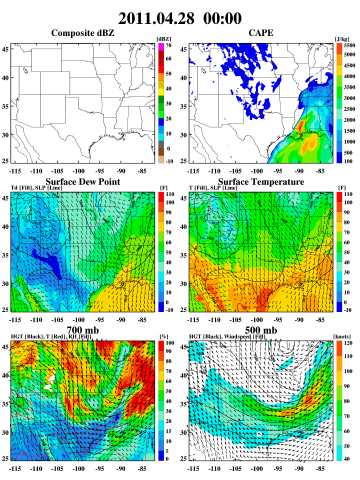
 The NASA Global Hydrology Resource Center (GHRC) DAAC published the GPM Ground Validation Weather Research and Forecasting (WRF) Images MC3E dataset. This data consists of browse only images showing radar reflectivity, radar echo top, convective available potential energy (CAPE), temperature, geopotential height, wind speed, relative humidity, rain water, snow, cloud water, cloud ice, and graupel. These data were simulated by the Weather Research and Forecasting (WRF) for the period of the GPM Ground Validation Mid-latitude Continental Convective Cloud Experiment (MC3E) field campaign. The overarching goal of the MC3E field campaign was to provide the most complete characterization of convective cloud systems, precipitation, and the environment ever obtained and to provide new constraints for model cumulus parameterizations and space-based rainfall retrieval algorithms over land. Browse imagery files in PNG and GIF formats are available for April 19, 2011 through June 6, 2011.
GPM GV WRF MC3E data Published
The NASA Global Hydrology Resource Center (GHRC) DAAC published the GPM Ground Validation Weather Research and Forecasting (WRF) Images MC3E dataset. This data consists of browse only images showing radar reflectivity, radar echo top, convective available potential energy (CAPE), temperature, geopotential height, wind speed, relative humidity, rain water, snow, cloud water, cloud ice, and graupel. These data were simulated by the Weather Research and Forecasting (WRF) for the period of the GPM Ground Validation Mid-latitude Continental Convective Cloud Experiment (MC3E) field campaign. The overarching goal of the MC3E field campaign was to provide the most complete characterization of convective cloud systems, precipitation, and the environment ever obtained and to provide new constraints for model cumulus parameterizations and space-based rainfall retrieval algorithms over land. Browse imagery files in PNG and GIF formats are available for April 19, 2011 through June 6, 2011.