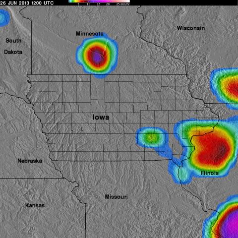
 The NASA Global Hydrology Resource Center (GHRC) DAAC published the GPM Ground Validation TRMM Multi-satellite Precipitation Analysis (TMPA) IFloodS datasets. This dataset is a subset of the TMPA 3B42RT gridded precipitation real-time product selected for the time period of the GPM Ground Validation Iowa Flood Studies (IFloodS) held in Iowa during April 1, 2013 to June 30, 2013. The goals of IFloodS were to collect detailed measurements of precipitation at the Earth’s surface using ground instruments and advanced weather radars and to simultaneously collect data from satellites passing overhead. TMPA is a calibration-based sequential scheme for combining microwave (MW) and infrared (IR) precipitation estimates from multiple satellites, as well as surface precipitation gauge analyses where feasible, to produce precipitation estimates at fine scales: 3-hourly, 0.25 degree maps. The TMPA IFloodS product is available in netCDF-4 and binary formats, as well as 3-hour rainfall browse images in JPG format. It should be noted that the GPM Ground Validation TRMM Multi-satellite Precipitation Analysis (TMPA) IFloodS dataset is a temporal subset of the TMPA 3B42RT Version-7 gridded precipitation product available at https://pmm.nasa.gov/data-access/downloads/trmm. The version number of this dataset matches the original TMPA product at NASA Goddard.
 GPM TMPA IFloodS dataset published
The NASA Global Hydrology Resource Center (GHRC) DAAC published the GPM Ground Validation TRMM Multi-satellite Precipitation Analysis (TMPA) IFloodS datasets. This dataset is a subset of the TMPA 3B42RT gridded precipitation real-time product selected for the time period of the GPM Ground Validation Iowa Flood Studies (IFloodS) held in Iowa during April 1, 2013 to June 30, 2013. The goals of IFloodS were to collect detailed measurements of precipitation at the Earth’s surface using ground instruments and advanced weather radars and to simultaneously collect data from satellites passing overhead. TMPA is a calibration-based sequential scheme for combining microwave (MW) and infrared (IR) precipitation estimates from multiple satellites, as well as surface precipitation gauge analyses where feasible, to produce precipitation estimates at fine scales: 3-hourly, 0.25 degree maps. The TMPA IFloodS product is available in netCDF-4 and binary formats, as well as 3-hour rainfall browse images in JPG format. It should be noted that the GPM Ground Validation TRMM Multi-satellite Precipitation Analysis (TMPA) IFloodS dataset is a temporal subset of the TMPA 3B42RT Version-7 gridded precipitation product available at https://pmm.nasa.gov/data-access/downloads/trmm. The version number of this dataset matches the original TMPA product at NASA Goddard. 