GHRC DAAC has published three more OLYMPEx datasets:
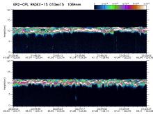
The GPM Ground Validation Cloud Physics Lidar (CPL) OLYMPEX dataset (image shown) consists of extinction profiles, layer optical depth, layer lidar ratio, and aircraft parameter measurements measured by the CPL flown on the NASA ER-2 aircraft during the Global Precipitation Mission (GPM) Olympic Mountains Experiment (OLYMPEX) campaign. http://dx.doi.org/10.5067/GPMGV/OLYMPEX/CPL/DATA101
The GPM Ground Validation Advanced Vertical Atmospheric Profiling System (AVAPS) OLYMPEX dataset contains dropsonde vertical profiles of atmospheric pressure, air temperature, dew point temperature, relative humidity, wind direction and magnitude, and sensor location obtained during the Olympic Mountains Experiment (OLYMPEX). http://dx.doi.org/10.5067/GPMGV/OLYMPEX/AVAPS/DATA101
The GPM Ground Validation NASA ER-2 Navigation Data OLYMPEX dataset supplies navigation data collected by the NASA ER-2 aircraft for flights that occurred during November 9, 2015 through December 15, 2015 for OLYMPEX. This navigation dataset consists of multiple altitude, pressure, temperature parameters, airspeed, and ground speed measurements in ASCII, ASCII-IWG1, and XML data file formats. http://dx.doi.org/10.5067/GPMGV/OLYMPEX/NAV/DATA201
