
The Real Time Mission Monitor
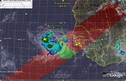
Screenshot image from Real Time Mission Monitor in Google Earth.
The NASA Real Time Mission Monitor (RTMM) is a situational awareness tool that integrates satellite, airborne and surface data sets; weather information; model and forecast outputs; and vehicle state data (e.g., aircraft navigation, satellite tracks and instrument field-of-views) for field experiment management. RTMM optimizes science and logistic decision-making during field experiments by presenting timely data, graphics and visualizations to the users to improve real time situational awareness of the experiment's assets. The RTMM is proven in the field as it supported program managers, scientists, and aircraft personnel during the 2006 NASA African Monsoon Multidisciplinary Analyses (NAMMA) experiment in Cape Verde, the 2007 Tropical Composition, Cloud and Climate Coupling (TC4) experiment in Costa Rica, the 2007 NOAA-NASA Hurricane Aerosonde Demonstration Project, the 2008 Arctic Research of the Composition of the Troposphere from Aircraft and Satellite (ARCTAS) experiments, the 2008 Soil Moisture Active Passive Validation Experiment (SMAP VEX), 2010, the 2010 Genesis and Rapid Intensification Processes (GRIP) Field Campaign, and 2012-2014 QUASAR UAV Experiments. The integration and delivery of this information is made possible through data acquisition systems, network communication links and network server resources built and managed by collaborators at NASA Dryden Flight Research Center (DFRC) and Marshall Space Flight Center (MSFC). RTMM is evolving towards a more flexible and dynamic combination of sensor ingest, network computing, and decision-making activities through the use of a service oriented architecture based on community standards and protocols.
