Hurricane
WHAT IS A HURRICANE?
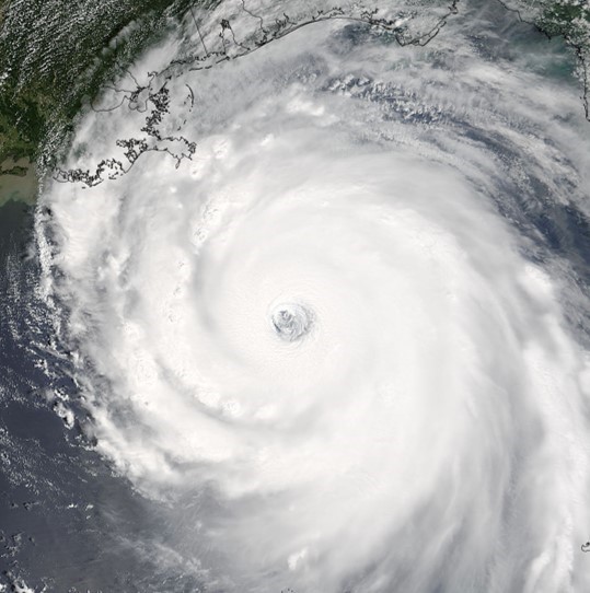
Hurricanes, or tropical cyclones, are large rotating storm systems with low pressure centers and high winds that typically last from several days to slightly more than a week. Only when the maximum sustained wind speed reaches 119 kilometers per hour (74 miles per hour) do we refer to these storms as hurricanes. The term “hurricane” refers to tropical cyclones that forms in the North Atlantic and Eastern Pacific ocean basins, however, in other areas of the world hurricanes are referred to as “typhoons”, “tropical cyclones”, and “cyclones”. Due to the effect of Earth’s rotation, hurricanes rotate counterclockwise in the Northern Hemisphere and clockwise in the Southern Hemisphere. The Saffir-Simpson Hurricane Wind Scale is commonly used to categorize hurricane strength into five categories based on each hurricane’s maximum sustained winds, which are representative of potential structural wind damage. Hurricanes also cause a number of other hazards including heavy rainfall, high waves, rip currents, flooding, storm surge, tornadoes, high winds, landslides and lightning.
Why do hurricanes occur?
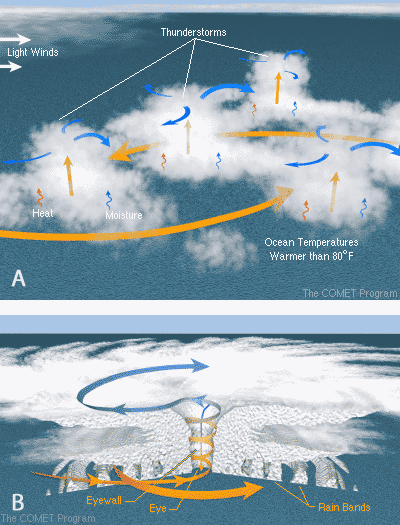
Hurricanes occur in the tropics and subtropics where there is warm, moist air and a low pressure disturbance causing air to converge and rise. Near the equator, hurricanes cannot form due to the lack of the Coriolis force needed for storms to rotate. In the Atlantic Ocean, most hurricanes form from easterly waves, or troughs of low pressure that originate over Africa. Through surface evaporation, warm sea surface temperatures serve as the main fuel source for hurricane formation. Easterly waves force warm, moist air to rise, creating clouds and thunderstorms. As the warm, moist air rises and produces clouds and precipitation, it releases latent heat through condensation of the rising water vapor molecules. This release of latent heat causes warming aloft making the air pressure higher and causing air to move outwards, or diverge away from the storm. This, in turn, causes the surface pressure to lower, enhancing convergence of air into the storm at the surface, increased evaporation, rotation, and wind speeds. Once the peak wind speeds reach 119 kilometers per hour (74 miles per hour), a hurricane is formed. Hurricanes require deep, warm ocean water as an energy source and low wind shear (change of wind speed and direction with height) to enable storms to grow without being torn apart. The environmental conditions surrounding a hurricane determine whether it will continue to strengthen or weaken. High wind shear, dry air, land, and cool water all prevent hurricane formation and can weaken existing storms.
Where do hurricanes occur?
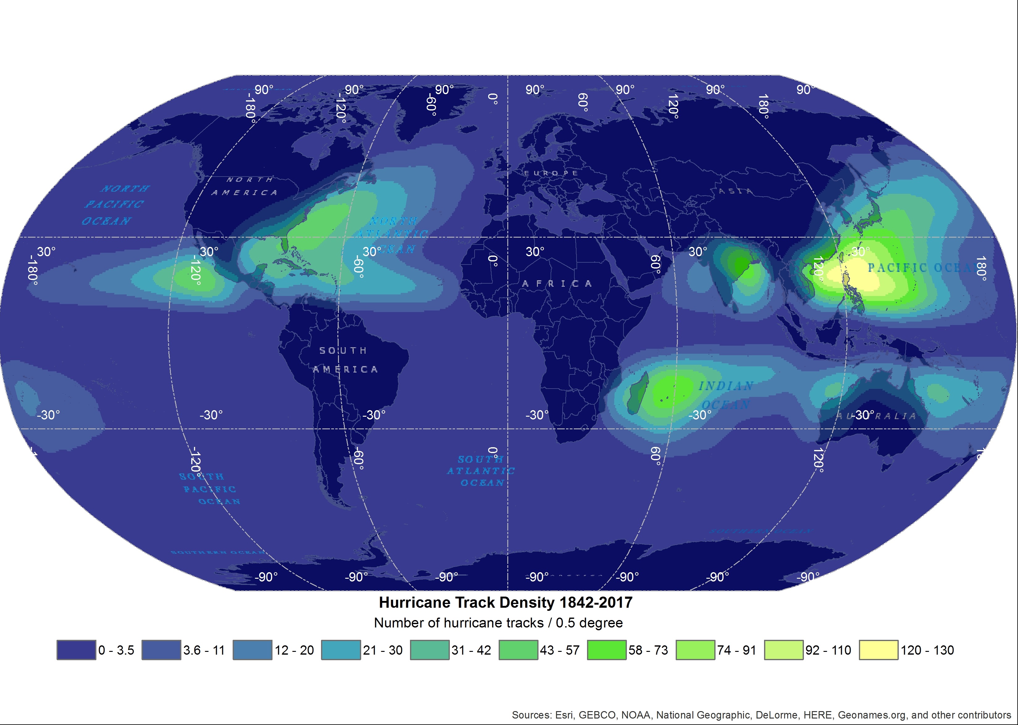
Hurricanes (tropical cyclones) form within the Atlantic, Pacific, and Indian ocean basins in the tropics and subtropics, however, where they form within these basins is determined by the ocean currents, a pre-existing low pressure area, and the proximity to the equator. As previously mentioned, hurricanes rarely form within 5 degrees of the equator due to the lack of Coriolis force. In the South Atlantic and southeastern Pacific oceans, hurricanes do not form because the ocean currents in these areas transport cooler polar water towards the equator, failing to provide the source of fuel needed for hurricanes to form. Once a hurricane forms in the tropical and subtropical regions of these ocean basins, they travel northward/southward into the midlatitudes where they weaken as they move over land and cooler ocean waters.
HOW ARE HURRICANES OBSERVED?
Many spaceborne, airborne, and ground- and ocean-based instruments are used to monitor hurricanes. Spaceborne satellites retrieve information needed to track and understand hurricane evolution and intensity, particularly the rainfall occurring within the storm, and the environmental conditions surrounding the hurricane. This information helps inform forecasters who use it with numerical forecast models to predict the future path and strength of the storm. Aircraft instruments are flown into hurricanes to acquire detailed measurements needed to better understand underlying processes that govern the size and intensity of a hurricane. Instruments at sea situated on buoys and ships provide information about ocean and atmospheric conditions. Ground-based measurements offer information on how intense the precipitation, atmospheric pressure, and wind speeds of the hurricane are. Weather radars are used to observe rainfall in hurricanes, however, many are unable to be used until the storm nears landfall, given that they are located on land.
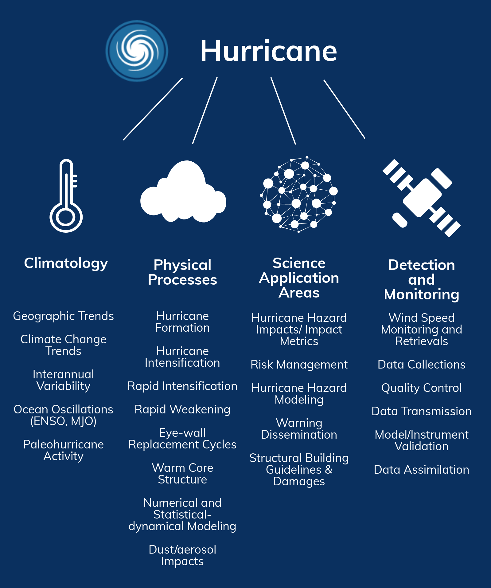
To better understand how hurricanes form, strengthen, and weaken, scientists conduct research projects using many different types of aircraft-, satellite-, and ground-based instruments.
GHRC Projects Containing Data used to Study Hurricanes
| PROJECT | RELEVANT INSTRUMENTS | PLATFORM TYPE | HOW WERE THESE DATA USED? |
|---|---|---|---|
| CAMEX-1, 2, 3, 4 | Radar Ceilometer Lidar AMPR GOES-8 Field Mill Hygrometer Cloud Physics AMPR Rawindsondes Radiosondes Aerosonde Dropsonde MTP Microwave Profiling Radiometer SODAR AERI HAMSR SAW MAMS Absorption Ozone Photometer Doppler Wind Profiler |
Airborne
Ground-based | Understanding hurricane development, tracking, intensification, and landfalling impacts |
| GRIP | HIWRAP HIRAD LIP HAMSR DAWN Dropsonde APR-2 GEOS-11,13 GHIS Radiosonde Cloud Microphysics Lidar |
Airborne
Spaceborne | Understand the formation and development of tropical storms into major hurricanes. |
| HS3 | HIWRAP HIRAD AVAPS CPL WWLLN HAMSR S-HIS |
Airborne | Tropical cyclone development Electric field measurements Electrical structure of storms Total lightning Electric charge Air conductivity |
| LANCE | AMSR-2 |
Spaceborne | Provides low-latency data products to observe hurricanes. |
| TCSP | GEOS 11 Aerosonde CRS HAMSR Doppler Radar MTP LIP Ticosonde |
Ground-based
Spaceborne | Tropical cyclone structure, genesis, intensity change, moisture fields and rainfall. Satellite and aircraft remote sensor data assimilation and validation studies pertaining to development of tropical cyclones. The role of upper tropospheric/lower stratospheric processes governing tropical cyclone outflow, the response of wave disturbances to deep convection and the evolution of the upper level warm core. |
| SANDS | MODIS |
Spaceborne | Sediment redistribution after hurricanes. |


RESEARCH AND APPLICATION AREAS

Dec 2nd, 2022

