May 11 Mission Scientist
Mission Science Report 11 May 2011
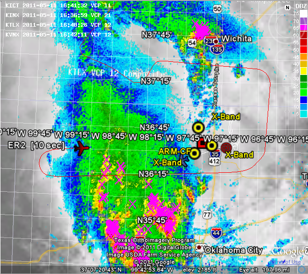
Mission was put together for 15 UTC Er-2 and 16 UTC Citation take-off to sample evolving precipitation shield in western OK that was slowly moving toward the CF. In fact, we thought we were going to get the “dream scenario” accomplished. The ER-2 took off as scheduled and we placed him on a NW-SE line to get some of the land surface ahead of the approaching convection and stratiform (at this time, the system was weaker but wide spread, being fed by dying convective cells propagating into the cloud mass from the south). We had the ER-2 briefly deviate along the line to sample a short transect of convective cells in southern KS along the border and then directed him to head for the first point of an E-W storm track after that. Meanwhile the Citation got off the deck at ~1605 UTC. We were going to have the Citation take an ascending aerosol profile toward the NPOL ahead of the approaching system before he made a right turn to get on our first planed E-W transect of the precipitation (six stacked legs separated by 3000 feet in altitude from FL240 to FL90 through the freezing level). He did make the aerosol profile but unfortunately the KC Center would not permit the Citation to enter Vance’s airspace. This delayed, by some 30-40 minutes (20 minutes of hold and another 10-20 minutes moving to get on the line etc.), our ability to get the Citation on a leg with the ER-2, who had already started, in terms of E-W transects. Jan Nystrom called the Vance Ops who then called KC Center and things got worked out. By this time the Citation began its E-W line, but the convection had moved closer to the transect from the south, there was more lightning etc., and we worked out another leg for it to fly to the north. The Citation did eventually get on this line (we had already moved the ER-2 line in anticipation). The Citation flew the line but as time moved on, embedded weak, very small convective cores within the nimbostratus became a problem. The cores appeared somewhat randomly within the broader stratiform shield and the Citation diverted along the flight leg as needed.
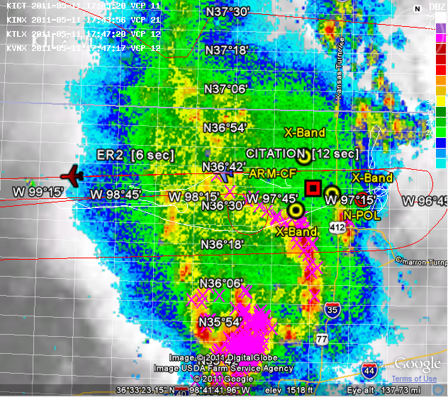
By 1755 we received word that the ER-2 was going to be called back due to impending weather at Offutt- right when we finally got all the traffic coordination issues and other things worked out and our best coincident lines. The last 1-2 lines that the ER-2 flew were almost directly over the Citation and so should be very solid and actually, most of the sampling occurred well within the instrument swaths, but not perfect. *SHOULD* BE A GOOD DATA SET. Very near this time the embedded cells, which were very small, were becoming more vigorous and frequent (very clear if you contrast the attached png files of 1600 UTC and 1750 UTC composites of reflectivity and lightning- marked change in intensity), so, we decided to get the Citation back on the east side in much weaker precipitation.
We gave the Citation a slant path though the stronger stratiform, but, unfortunately the Citation needed to continually deviate north along the backside of the stratiform, with the goal of a northern “end around” to get to our sample point. However, KC Center would not allow them to go far enough north to get around the system and sent the Citation right back to the south (which we judged to be back into harms way based on system development). With an hour of fuel left, and an intensifying system a decision was made to have the Citation then shoot a gap in the “weaker” stratiform (NW- SE) and return to base. However, Ponca City got socked in, Stillwater as an alternate was no good, and so they ended up in Tulsa.
During the airborne sampling we put NPOL in a six-elevation RHI sequence that intersected the approximate mid-point of the transects.
In the end, we appear to have collected a solid two hours of ER-2 data with all instruments functioning to the best of our knowledge (we still need to verify this), and with about one hour and 20 minutes of coordinated sampling with the Citation (as best that it could be accomplished per previous comments).
Post aircraft mission the NPOL radar was placed in a rain-variabilty scan for a couple of hours of moderate stratiform rain. The APU/2DVD network was also up and the X-bands were placed in vertically pointing mode. 3-hourly soundings were collected all day in advance of this mission and were to end at 0530 UTC on 5/12/11.
Walt P./ Larry C.
| Attachment | Size |
|---|---|
| 11May2011_1650Z_rtmm.png | 538.75 KB |
| 11May2011_1754Z_rtmm.png | 533.12 KB |
