April 22 Afternoon Forecast

MC3E banner

Campaign Forecast Afternoon Update, Friday April 22

Forecasts
 
Time of Day: 
Afternoon
Day 0: 
04/22/2011
Forecast for Day 0: 

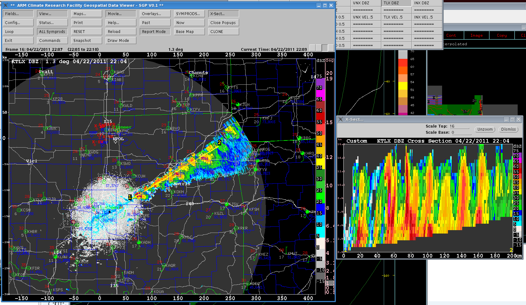
As was forecasted in the morning briefing, a surface cold front moved through the SGP this morning effectively ending our chances for precipitation today.  As the front reached Tulsa and OKC between 20Z and 21Z, convection initiated along the front beginning in far northeast Oklahoma, then near Tulsa, and finally between Tulsa and OKC.  A Tornado Watch was issued.  Below shows the convective line with a cross-section along it about the time that the ER-2 was doing its first pass along the line.

Geospatial Data Viewer image.

Day 1: 
04/23/2011
Forecast for Day 1: 

Much of where precipitation develops will depend on where the front sets up throughout the day.  The best chance for the front to lift north toward the SGP is between 6Z and 12Z associated with a low pressure center forming along the front over southwest Oklahoma.  A 40 kt low level jet may be enough to lift moisture over the front and set off elevated convection during this time.  It appears that the front will be pushed farther south again later in the day as the low center moves south, limiting any chance for precipitation over north-central Oklahoma during that time.

Day 2: 
04/24/2011
Forecast for Day 2: 

An approaching broad and weak trough approaches the region and the front once again moves northward bringing the best chance for precipitation over the SGP from 6Z to 12Z.  Compared to earlier runs, moisture coming in with the low level flow appears to much farther east and a strong convective line sets up from south-central Oklahoma through northeast Oklahoma, similar to today's situation.  The difference is that a strong upper level jet max moves in out of the intermountain west and reinvigorates the upper level trough.  This will be the focus for precipitation over the SGP late Sunday night into Monday morning, although the precipitation predictions are less than in model runs from the previous couple of days.  There is still significant model spread and thus, we will have a better update tomorrow morning.
 

Extended Outlook: 

Another trough is still expected to dig south through the panhandle region setting up a possible situation for precipitation over the SGP on Tuesday afternoon and evening.


Have you used our data? Register for updates