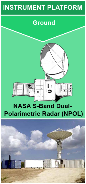
Instrument: NASA S-band Dual Polarimetric Radar (NPOL)

Description

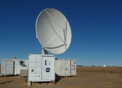
The NASA S-band Dual Polarimetric Radar (NPOL) is a research grade S-band, scanning dual polarimetric Doppler radar. It has equivalent capabilities to the Doppler radars of the U.S. National Weather Service’s Next Generation Weather Radar (NEXRAD) network. However, in contrast to the stationary NEXRAD radars, NPOL is one of two completely transportable research-grade S-band systems in the world. The radar operates atop a pedestal and 5 intermodal containers (i.e., sea containers) and is stored inside these containers when being transported for deployment. NASA’s NPOL weather radar has been and continues to be used for various NASA field campaigns. It resides and operates near NASA’s Wallops Flight Facility in Newark, MD when not on field campaign deployment.

Figure 1: NASA S-band Dual Polarimetric Radar (NPOL) 
(Image source: NASA GSFC)
 
Weather radars use electromagnetic (EM) radiation to detect atmospheric targets. The radar’s transmitter emits a short “pulse” of radiation energy toward a volume of precipitation particles. The transmitter is then paused while the receiver “listens” to detect the radiation that is reflected back (i.e., backscattered) toward the radar where the signal will be measured.The rate at which the pulse is transmitted by the radar, known as the pulse repetition frequency (PRF), can vary. For NPOL, the PRF can range from 500 - 1000 Hz. These measurements give information such as the amount and size of the atmospheric targets. 
The “S-band” ranges from 2 to 4 GHz and lies in the microwave region of the EM spectrum, a region commonly used for weather observations. NPOL uses a 850 kW magnetron transmitter and an 8.5 m parabolic antenna to transmit radiation at 2.7 to 2.8 GHz (S-band) with a 0.95° beamwidth. “Dual polarimetric” means that the NPOL can transmit pulses at two orientations, horizontal and vertical. These measurements allow the radar to identify precipitation type and other microphysical characteristics. NPOL is also a Doppler radar, meaning it can resolve wind velocities within precipitation. The speed and direction of movement by precipitation particles will affect the backscattered signal, revealing information about the air motions relative to the radar. NPOL’s antenna can be maneuvered to complete three different types of radar scans including Plan Position Indicator (PPI) where a 360 degree sweep of the antenna is made; PPI Sector (PPS) where the sweep of the antenna is limited to a specific azimuth range; and Range Height Indicator (RHI) in which scans are pointed at a specific azimuth and the antenna tilts upward to get vertical profile information. Range gates are specific distance intervals from the radar in which the radar return signal is measured. These gates are used to differentiate return signals originating at different distances from the radar. A diagram of an NPOL radar beam and scan is shown in Figure 2.
 
Figure 2: NPOL PPI scan and range gate diagram in (a) cylindrical and (b) Cartesian coordinates
(Image source: Bringi et al. 2013)


Measurements

Measures radar reflectivity, Doppler velocity, differential reflectivity, correlation, differential phase, rainfall rate, particle size distribution, water contents and precipitation type. When the radar antenna is wet, this can increase signal attenuation and lead to data quality issues. Self-consistency and disdrometer comparisons are used to estimate the absolute calibration of NPOL. Also, the pointing angle of the radar dish is monitored with software that uses the sun’s position to calibrate the elevation and azimuth angles.

Instrument Platform: Ground > NASA S-band Dual Polarimetric Radar (NPOL)
Applications
Satellite validation
Precipitation studies
Global water cycle
Global water cycle
Climate
Climate
Precipitation microphysics
FREQUENCY SPATIAL EXTENT BEAM WIDTH ACCURACY PULSE REPETITION FREQUENCY (PRF) ANTENNA GAIN PULSE WIDTH
2.7 - 2.9 GHz
(10.65 cm wavelength)
150 km range 0.95° 0.1° pointing accuracy 500 - 1000 Hz 8.5 m 45.8 dB
(+/- 0.3 dB)
0.8 - 2.0 ms


Relevant Publications

Bringi, V.N., L. Tolstoy, M. Thurai, & Petersen, W.A. (2015). Estimation of Spatial Correlation of Drop Size Distribution Parameters and Rain Rate Using NASA’s S-Band Polarimetric Radar and 2D Video Disdrometer Network: Two Case Studies from MC3E. Journal of Hydrometeorology, 16, 1207–1221. https://doi.org/10.1175/JHM-D-14-0204.1

NASA Wallops Precipitation Science Research Facility. (2020). NASA S-band Dual-Polarimetric Radar (NPOL). https://wallops-prf.gsfc.nasa.gov/Radar/NPOL/index.php
 
Petersen, W.A. & Wolff, D.B. (2013). The NASA Polarimetric Radar (NPOL). https://ntrs.nasa.gov/archive/nasa/casi.ntrs.nasa.gov/20140010713.pdf


Have you used our data? Register for updates