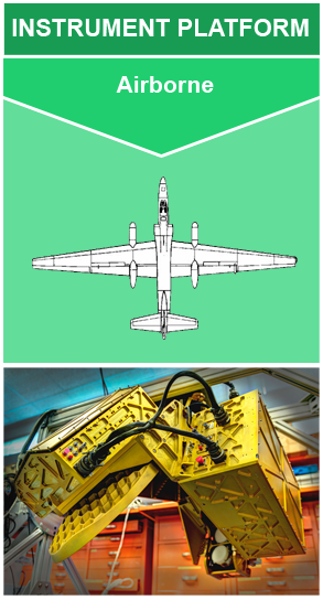
Instrument: High Altitude Imaging Wind and Rain Airborne Profiler (HIWRAP)
The High Altitude Wind and Rain Airborne Profiler (HIWRAP) instrument is a Doppler radar designed to measure tropospheric winds through deriving Doppler profiles from cloud and precipitation volume backscatter (Li et al. 2016). The winds are generated by combining conical scan mode measurements at two different frequency bands (Ka- and Ku-band) and two different incidence angles (30 and 40 degrees). HIWRAP utilizes solid state transmitters along with a novel pulse compression scheme. This results in a system that is considerably more compact and requires less power than typical radars used for precipitation and wind measurements. HIWRAP has flown science flights on the NASA high-altitude (20 km) Global Hawk Unmanned Aerial Vehicle (UAV) and the NASA ER-2. HIWRAP has two modes of operation: Global Hawk with scanning, and ER-2 in a fixed nadir pointing configuration. More information about HIWRAP can be found at the Goddard Space Flight Center High Altitude Radar Group: https://har.gsfc.nasa.gov/index.php?section=13 and Li et al., 2016.
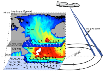
HIWRAP observes radar reflectivity, Doppler velocity, and wind. HIWRAP is able to do this by observing the backscattering from clouds and precipitation. This enables the instrument to measure the tropospheric winds above heavy rain at high levels. Due to aircraft ground speed and storm system winds, Doppler measurements are potentially folded for some volume cells. However, different techniques, such as geometry correction, dual-pulse repetition frequency, and frequency diversity Doppler processing are used for Doppler velocity unfolding. The instrument parameters are for wind retrievals in 1 km x 1 km x 60 m pixels. These details are from the Goddard Space Flight Center High Altitude Radar Group: https://har.gsfc.nasa.gov/index.php?section=13.
| PARAMETER | RANGE | ACCURACY |
|---|---|---|
| Horizontal Wind Speed | 0-100 m/s | 2 m/s |
| Horizontal Wind Direction | 0-360 deg | 15 deg |
| Ocean Surface Wind Speed | 0-60 m/s | 2 m/s |
| Ocean Surface Wind Direction | 0-360 deg | 15 deg |
| Vertical Wind Speed | +/- 20 m/s | 2 m/s |
Heymsfield G.M., L. Tian, A. Heymsfield, L. Li, and S. Guimond (2010). Characteristics of Deep Tropical and Subtropical Convection from Nadir-viewing High-altitude Airborne Doppler Radar, J. Atmos. Sc, 67(2), 285-308, https://doi.org/10.1175/2009JAS3132.1
Li, L. et al. (2016). The NASA High-Altitude Imaging Wind and Rain Airborne Profiler, IEEE Transactions on Geoscience and Remote Sensing, 54(1), 298-310, https://doi.org/10.1109/TGRS.2015.2456501
Li, L., G.M. Heymsfield, J. Carswell, D. Schaubert, M. McLinden, M. Vega, M. Perrine (2011). Development of the NASA High-Altitude Imaging Wind and Rain Airborne Profiler, presented at IEEE Aerospace Conference, https://doi.org/10.1109/AERO.2011.5747415

Jun 25th, 2020
Instrument

