Mission Summary
20050724I1 Aircraft 43RF
IFEX Genesis Flight 2005
| Rob Rogers | LPS |
| Peter Dodge | Radar |
| Daniel Stern | Dropsonde |
| Pilots | Randy Tebeest Mike Silah |
| Flight Engineer | Steve Wade |
| Navigator | Tim Gallagher |
| Flight Director | Paul Flaherty |
| Data Engineers | Sean McMillan John Hill Mark Rogers |
Mission Plan :
Follow-on mission into Tropical Storm Gert in southwest Bay of Campeche. Flew butterfly pattern, with the legs shortened on west side of pattern due to proximity to Mexican coast. This mission completed the genesis survey of Gert, which consisted of four 12-h back-to-back missions into the system. Today's flight investigated the response of the vortex to the previous night's strong convective heating.
Mission Summary :
The NOAA N43RF flew a genesis mission as a part of IFEX into Tropical Storm Gert in the western Gulf Of Mexico. The P3 left MacDill AFB, FL at 1:00 PM EDT and recovered at MacDill AFB, FL by 9:15 PM EDT.
During the overnight flight (N43RF) T.D. #7 was upgraded to Tropical Storm Gert. Gert was positioned in the southern Bay of Campeche, but in the 11 AM EDT advisory NHC indicated the possibility of two centers, one located just north of the coast and the other located further north and west, possibly the one sampled by the overnight flight and tied to the overnight convective development. The plan called for a final follow-on P-3 mission to occur during the afternoon of July 24. At the time of takeoff on 17 UTC Gert was about 100 nm southeast of Tampico, Mexico, and was moving west-northwest at about 9 kt. It was hoped that the P-3 would be able to reach Gert before it made landfall, so that it could sample the west side of the storm.
The flight track called for a butterfly pattern intended to provide maximum azimuthal resolution to this weak system (Fig. 1). The plan called for a total of 16 GPS drops and 2 AXBTs. Center drops would be made on the first and third passes through the center. In the event that the storm was too close to the coast, the western portion of the pattern would be shortened and the drop locations modified accordingly.
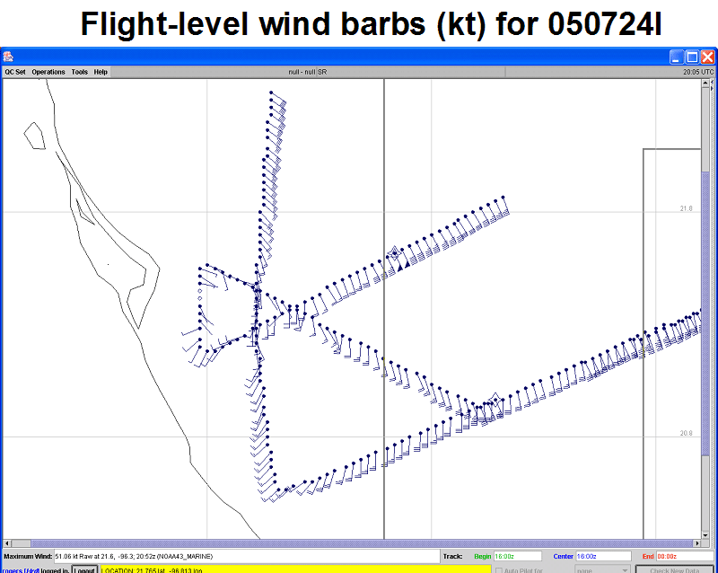
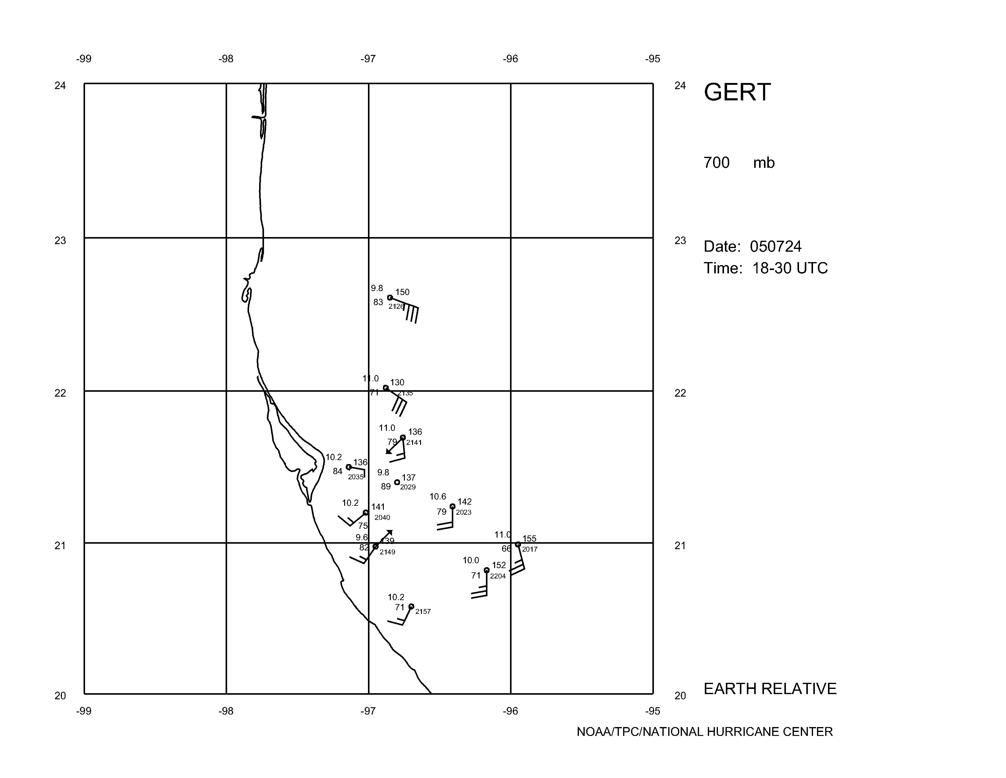
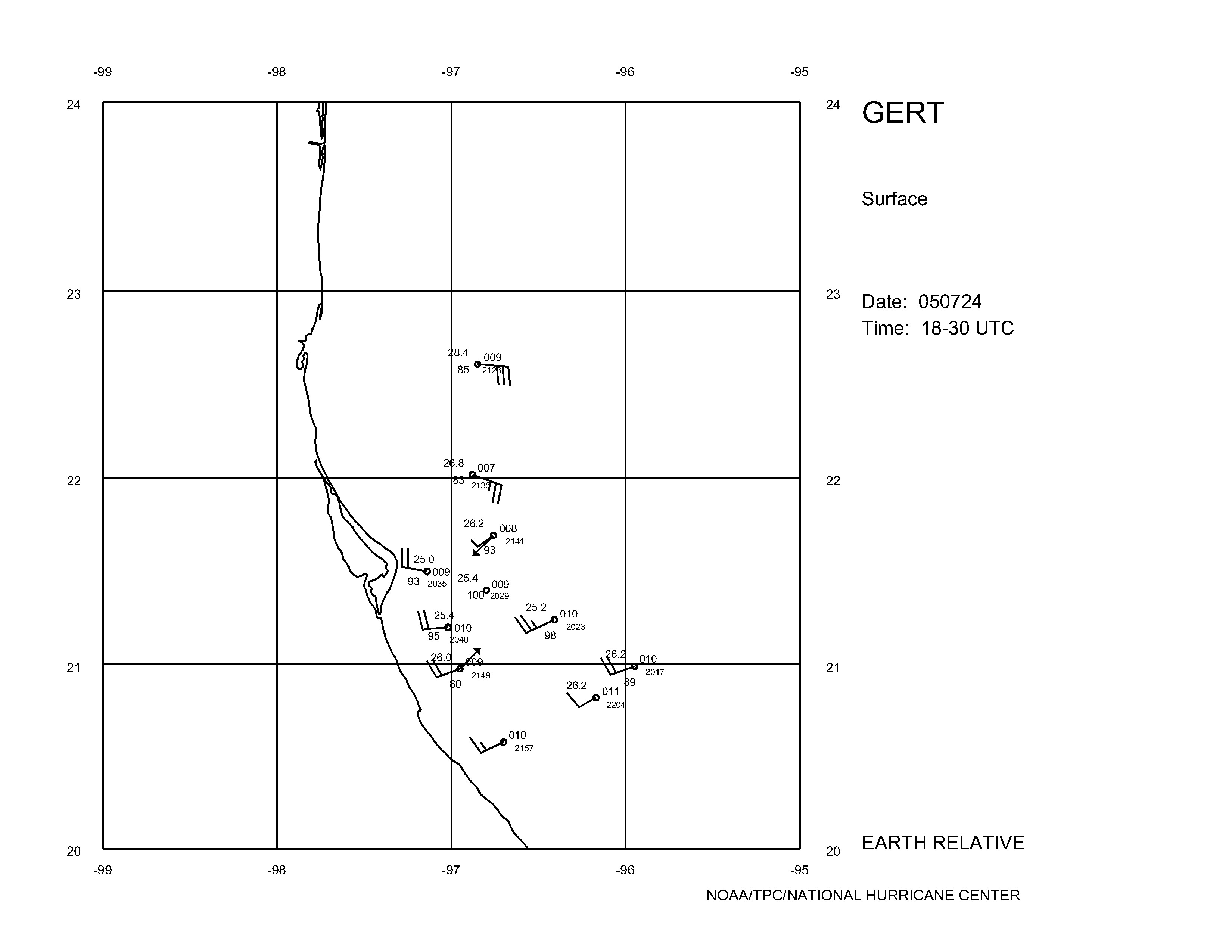
By the time the storm was reached most of the concentrated deep convection from the previous night had decreased in areal coverage, leaving some convection on the north and east side of the storm. Flight-level winds (Fig. 3) and dropsonde data from the mission (Fig. 4) showed a complex pattern. Multiple wind shifts and pockets of weak winds at
Figure 1. Proposed track of flight 20050724I.
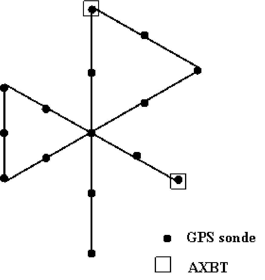
Figure 2. Proposed locations of GPS and AXBT drops for flight 20050724I.
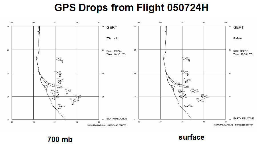
flight level suggested the possibility of multiple centers. The drops appeared to have captured the primary vortex at the surface, but this vortex center seemed displaced from the centers at 700 and 850 mb (850 mb not shown). It appeared that the surface circulation center was further east than the 700 and 850 mb center. The drops were unable to capture the multiple centers, but that is not surprising considering their coarser

Figure 3. Flight level wind barbs (kt) for flight 20050724I.
resolution. The flight-level data showed two, possibly three centers: one at about 21 °N 97.2 °W, one at 21.7°N 97.5 °W, and perhaps a third inland at about 21.4 °N latitude. The pattern seemed to indicate a broad circulation pattern that was fairly well-defined with an inner-core characterized by these multiple centers. The pattern only appeared to capture the eastern part of the broad vortex, but the pattern was able to capture all or some of the smaller-scale vortices within this broader circulation. Landing occurred at MacDill at 0113 UTC. It will be interesting to compare these data with the data from the previous night's mission to try to establish continuity with the broad-scale as well as the smaller-scale vortices.
(a)
(b)
Figure 4. Plot of GPS drops from 20050724I flight at (a) 700 mb; and (b) surface.
PDF of maps of drops from this flight.
Problems :
The AXBT's and the SFMR did not work.
Data :
| Start | End |
| 00:48:25 Z | 07:16:23 Z |
Taken from this AOML page
Wind NOAA-43