![]()
Disclaimer: The TCSP experiment concluded several years ago, and some of the links below may no longer function correctly.
- NASA Disassembles and Reassembles Tropical Storm Gert
- Can lightning help measure hurricane? NASA scientists probe for clues to better predictions
- NASA's Tropical Cloud Systems and Processes (TCSP) Experiment: Investigating Tropical Cyclogenesis and Hurricane Intensity Change, Halverson et al., submitted to BAMS 2006 (pdf)
- Atlantic Hurricane Season 2005 Movie (Credit GSFC SVS, Remote Sensing Systems and AMSR-E SIPS)(mpg 22.5 mb)
-
NASA Researchers Back Home after Successful Tropical Storm Tracking
Mission in Costa Rica - NASA'S ER-2 Flies over Hurricane Emily's Eye
- Status Report 7-28-05
- Status Report 7-27-05
- Status Report 7-26-05
- Status Report 7-25-05
- Status Report 7-21-05
- Status Report 7-19-05
- Status Report 7-18-05
- Status Report 7-15-05
- Status Report 7-11-05
- Status Report 7-2-05
- NASA to Study Severe Storms Near Costa Rica
- NASA Researchers Studying Tropical Cyclones
- NASA Announces Dangerous Weather Media Conference
- NASA Team Studies Hurricanes in Costa Rica (Courtesy of The Tico Times) (pdf)
Can lightning help measure hurricane? NASA scientists probe for clues to better predictions
Monday, April 24, 2006, by SHELBY G. SPIRES, Times Aerospace Writer, shelbys@htimes.com
NASA researchers in Huntsville hope their work studying intense weather will lead to advanced sensors that may help scientists better predict the path and severity of hurricanes.
The local scientists think atmospheric events such as lightning and sea temperature can show how strong a hurricane might actually become.
Research from last year's hurricane season shows that lightning occurs more frequently and becomes stronger across the life of a storm. In the past, the belief was that lightning peaked at certain points in a storm's development and then became weaker as the storm's intensity grew.
Dr. Richard Blakeslee, with the National Space Science and Technology Center in Huntsville, has been studying lightning in hurricanes and worked on last year's research team, which was based in Costa Rica.
Lightning by itself is not sufficient to determine if a storm is strengthening or weakening, Blakeslee said, but by combining lightning activity with other hurricane information, such as wind-shear speeds and temperature ranges, scientists might be closer to understanding and predicting a hurricane's path and strength earlier in the storm cycle.
Research to date has filled in some gaps, but opened up other questions.
"We have a lot to do to understand lightning and the way it interacts" in a hurricane pattern, Blakeslee said, "but it validates some thoughts about the lightning."
Last year was one of the most intense hurricane and storm seasons on record, but to weather scientists in Huntsville it provided a wealth of information about the intense storms and their formation cycles.
In July 2005, a group of more than 100 scientists went to San Jose, Costa Rica, to take part in the Tropical Cloud Systems and Processes field experiment and study a series of hurricanes.
The group used instruments in a NASA ER-2 - the research version of the U-2 spyplane - to gather high-altitude information about storms and hurricanes.
Along with the converted spyplane, a National Oceanic and Atmospheric Administration P-3 Orion aircraft, loaded with researchers and equipment, winged its way through some of the storms. A small unmanned aerial vehicle also took low-altitude measurements such as ocean temperatures and wind readings.
Scientists hope that the intense study will allow them to build better instruments that can be used to detect and predict storm paths.
"Today, instruments in space give us a narrow, short-time field of view for a hurricane or area or weather pattern," said Dr. Gerry Heymsfield, a mission scientist who works at Goddard Space Flight Center. "By placing instruments on an aircraft or an unmanned aerial vehicle, we can get really detailed data very quickly and when we need it. There's benefit from both platforms."
Another hurricane study field experiment is planned this year, and may take place in Cape Verde Islands, NASA officials said last week. The ultimate goal is to design a satellite that can monitor storms from space.
"Field work is invaluable, but what NASA would like to do is use this work, and the research that goes on here in Huntsville, to design more effective satellites to monitor hurricane formation conditions through remote, or space-based, sensing," said Dr. Ramesh Kakar, who works at NASA headquarters and manages the Tropical Cloud Systems and Processes field experiment.
NASA RESEARCHERS BACK HOME AFTER SUCCESSFUL TROPICAL STORM TRACKING MISSION IN COSTA RICA
Researchers are drying off after a successful Tropical Cloud Systems and Processes (TCSP) mission. During the Costa Rica based mission, scientists tracked two major Atlantic Ocean hurricanes at the height of their destructive power, witnessed the entire lifecycle of tropical storms in the Atlantic and documented a number of unexpected surprises about the short, violent lives of these seagoing tempests.
"It was unbelievably successful," said Dr. Robbie Hood, Atmospheric scientist at NASA's Marshall Space Flight Center, Huntsville , Ala. " Of course, we study the weather because we don’t always understand it. Many times what we expect is not what we get. This time, we were incredibly lucky and very surprised. We were not expecting the tropical cyclones of the Caribbean Sea and Gulf of Mexico to be so numerous this early in the hurricane season."
Partnering with the National Oceanic and Atmospheric Administration (NOAA) and Costa Rican Centro Nacional de Alta Tecnologia (CENAT), the NASA team spent July conducting ground-based and airborne studies of tropical storm systems on Costa Rica 's east and west coasts. They primarily intended to investigate the birthplace of eastern Pacific tropical cyclones, and did so in detail -- but a record-breaking early start to a busy Atlantic hurricane season added numerous other research opportunities to the mission.
“Thanks to the NASA team’s hard work and a strong commitment from our NOAA and Costa Rican partners the TCSP experiment was a huge success," said Dr. Ramesh Kakar, Weather Focus Area leader for NASA's Science Mission Directorate. "The weather systems cooperated beautifully and we were very fortunate to complete, and in some cases even exceed, our planned objectives.”
During the project, NASA's high-altitude ER-2 aircraft flew 13 missions and NOAA's two WP-3D Orion aircraft flew 20 missions . For the first time, scientists were able to use real-time streaming data, from instruments on the ER-2, to more accurately guide aircraft pilots, even in the dead of night. The team also employed small, unmanned aerial vehicles, a series of balloon-borne weather probes and several low-earth, polar - orbiting and geostationary NASA and NOAA satellites.
Here are some of the most noteworthy milestones of the 30-day mission:
- The rapid genesis of Hurricane Dennis in a region of the Caribbean where such dramatic development is rare. During the study, the storm's pressure dropped 12 millibars in two hours -- equivalent to how much a garden-variety low pressure system over the United States may intensify in about 24 hours. Researchers hope data from Dennis will help improve understanding of this "rapid deepening" phenomenon.
- Hurricane Dennis provided another amazing observation, when the hurricane -- as a powerful Category 4 -- passed over Cuba 's mountainous terrain, severely disrupting its well-defined eye and weakening it to a Category 2 hurricane. When it re-emerged over warm waters north of Cuba , the storm quickly regained its former strength and intensity.
- While monitoring a narrow Pacific region called the "Inter-Tropical Convergence Zone," scientists were able to watch the birth of Tropical Storm Eugene.
- The ER-2 and its veteran pilot, NASA aviator David Wright, overflew the most powerful hurricane of their career while studying the borderline Category 4-5 Hurricane Emily. The ER-2 recorded frequent lightning, unusual in hurricanes, and captured startling Doppler radar imagery of Emily, including "eye wall" storms rising to a rarely observed height of 60,000 feet.
- The ER-2 and P3 Orion flew five back-to-back missions enabling the team to monitor the entire lifespan of Tropical Storm Gert, which developed from an elongated area of low-pressure or "trough" off the Yucatan coast. The ER-2 also investigated the impact of Mexican mountain ranges on Gert as the storm made landfall.
The TCSP mission was conducted to document "cyclogenesis," the mysterious formula of rainfall, air and sea temperature, pressure and other factors required to spawn tropical storm systems. Greater understanding of that process could be vital to understanding how hurricanes evolve, intensify and travel -- the key to developing earlier, more accurate warning systems.
"Understanding the genesis of tropical cyclones is a mystery that has eluded meteorologists for a very long time, due in large part to a lack of detailed observations," said Dr. Jeffery Halverson, Severe Weather Meteorologist at NASA's Goddard Spaceflight Center, Greenbelt, Md. "Now, by taking sophisticated research aircraft to the remote locations where hurricanes are born, TCSP scientists can begin to piece together the complex birth story of several tropical cyclones in the western hemisphere, some of which were unusually intense and others relatively weak."
Collation and analysis of the enormous amount of data compiled during the mission is expected to continue for more than a year.
The study continued NASA's successful Convection and Moisture Experiment (CAMEX) research series, conducted with NOAA from 1998 to 2001. TCSP participants included NOAA's Hurricane Research Division, NOAA's Aircraft Operations Center , five NASA centers, 10 American universities and partner agencies in Costa Rica .
For more information about TCSP on the Web, visit:
http://www.nasa.gov/vision/earth/lookingatearth/hurricane_2005.html https://ghrc.nsstc.nasa.gov/home/field-campaigns/tcsp
http://www.aoml.noaa.gov/hrd/
Erica Hupp, National Aeronautics and Space Administration, Headquarters PAO, Washington, D.C.
NASA'S ER-2 FLIES OVER HURRICANE EMILY'S EYE
|
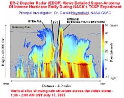
As Hurricane Emily lashes the coast of northeastern Mexico and southern Texas , a NASA ER-2, from the Dryden Flight Research Center at Edwards Air Force Base, Calif. , flew high over the storm as it moved across the Caribbean Sea to the Gulf of Mexico .
On Sunday, July 17, the aircraft collected data during an eight-hour flight over Hurricane Emily. The hurricane is a powerful storm that has already caused extensive damage in Mexico 's Yucatan Peninsula . Flying at 65,000 feet, the ER-2 completed two passes over the eye of Emily, one of the most violent storms the NASA aircraft and pilot David Wright have ever experienced.
"Hurricane Dennis was much kinder," said Wright after Sunday's flight. "Emily just didn't want me around."
A team of atmospheric scientists, engineers and aircraft personnel have taken up residence in San Jose , Costa Rica during July studying how tropical storms become hurricanes during the Tropical Cloud Systems and Processes (TCSP) mission . The NASA team is working with the National Oceanic and Atmospheric Administration (NOAA) and Costa Rican Centro Nacional de Alta Tecnologia (CENAT) .
The TCSP team is conducting ground-based and airborne studies to measure the buildup and behavior of tropical storm systems on Costa Rica 's east and west coasts. The airborne experiments are collecting temperature, humidity, precipitation, and wind information related to tropical cyclones and other phenomena that often lead to development of more powerful storms at sea. The field operations are also taking advantage of several NASA and NOAA satellites.
NASA and NOAA aircraft have flown numerous missions over Hurricane Dennis in early July. The aircraft and scientists have been tracking Emily since July 16 using some of the most sophisticated high-flying and ground-based weather research equipment.
"Instruments onboard the ER-2 recorded unprecedented detail of the hurricane vertical structure and precipitation levels," stated Jeff Halverson, TCSP deputy project manager from the NASA Goddard Space Center , Greenbelt , Md.
"This was a very successful and interesting flight for the ER-2."
The eye-wall clouds powering Emily were extremely energetic and deep. Instruments carried by the ER-2 detected large amounts of lightning and thunderclouds rising to approximately 60,000 feet.
In addition to NASA Dryden, four other NASA centers and 10 American universities are partnering in the study.
For more information about TCSP on the Web, visit:
http://www.nasa.gov/vision/earth/lookingatearth/hurricane_2005.html https://ghrc.nsstc.nasa.gov/home/field-campaigns/tcsp
http://www.aoml.noaa.gov/hrd/
National Aeronautics and Space Administration, Headquarters, Washington, D.C.
STATUS REPORT 7/28/05
NASA'S TROPICAL CLOUD SYSTEMS AND PROCESSES MISSION IN COSTA RICA
From July 22-24, storm hunters with the NASA Tropical Cloud Systems and Processes (TCSP) experiment in Costa Rica have documented the near-complete lifecycle of a tropical storm in the Atlantic Ocean.
Tropical Storm Gert, though short-lived and modest in terms of intensity, developed from a tropical wave near the Yucatan coast on July 22, intensified to tropical storm status on July 24, and made landfall that night over Mexico's northeast coast, where it quickly dissipated. During its genesis, intensification and landfall, NASA's ER-2 high-altitude weather plane, and the National Oceanographic and Atmospheric Administration's (NOAA) P3 Orion aircraft flew five back-to-back missions, enabling near-continuous study of the poorly understood process of tropical cyclogenesis, or the birth of hurricanes.
Tropical cyclogenesis often occurs irregularly, with key atmospheric events happening in fits and starts. The phenomenon rarely occurs close enough to Mexican and U.S. coastal radars to document. The three consecutive NASA ER-2 flights and five NOAA P3 flights to study Gert are expected to help clarify the mechanisms involved in formation and maturity of a tropical cyclone, and are expected to deliver detailed, comprehensive datasets.
NASA's ER-2 flew over the eastern coast of Mexico the night of July 24, investigating the steep mountains' impact on Gert as the storm made landfall. Mountainous terrain is known to greatly enhance rainfall produced by moist tropical airflow, often leading to freshwater flooding -- the number one killer during tropical cyclone landfall in the western hemisphere. The ER-2 datasets, combined with satellite images and data collected by the network of Mexican weather radars, should reveal the detailed structure of Gert's rain bands, their intensity and how they were influenced by specific features of the landscape.
The TCSP mission is testimony to the successful cooperation between NASA and NOAA. Together, these agencies have investigated nearly a dozen tropical storms in the Atlantic Ocean since 1998, part of NASA's Convection and Moisture Experiment (CAMEX) mission. TCSP, conducted from Costa Rica throughout July 2005, carries on this tradition. TCSP participants include NOAA, five NASA centers, 10 American universities and partner agencies in Costa Rica.
For more information about TCSP on the Web, visit:
http://www.nasa.gov/vision/earth/lookingatearth/hurricane_2005.html https://ghrc.nsstc.nasa.gov/home/field-campaigns/tcsp
http://www.aoml.noaa.gov/hrd/
National Aeronautics and Space Administration, Headquarters, Washington, D.C.
STATUS REPORT 7/27/05
NASA'S TROPICAL CLOUD SYSTEMS AND PROCESSES MISSION IN COSTA RICA
On July 24, NASA's ER-2 and NOAA's P3 Orion hurricane hunter aircraft made their second coordinated flight into an intensifying tropical disturbance off the Mexican coast -- the latest successful research flights in NASA's Tropical Cloud Systems and Processes (TCSP) mission in Costa Rica.
A day earlier, both aircraft flew coordinated flight patterns into "Atlantic Tropical Depression 7," near the Yucatan Peninsula. On that flight, the planes identified the start of broad circulation in middle levels of the atmosphere, and documented moderately intense tropical thunderstorms embedded within the circulation. As the aircraft tracked the disturbance, it transformed into a true tropical cyclone, and was renamed Tropical Storm Gert -- the seventh named tropical storm system of the Atlantic hurricane season.
The ER-2 and P3 Orion flew coordinated patterns, the former traveling at 65,000 feet, the latter near 14,000 feet. Together, the aircraft were able to investigate the broad depth of the tropical atmosphere that incubates weather disturbances. Initial studies focused on an intensifying region of vigorous tropical thunderstorms, which release energy into the atmosphere. If this release occurs in an area where winds happen to be spinning, "cyclogenesis" -- the birth of a tropical cyclone -- may result.
During the July 24 mission, the aircraft were able to observe an area of rotation within the remnants of the tropical thunderstorms. Data suggested the area of rotation was intensifying, possibly building from atmospheric mid-levels down to the ocean surface.
Observations such as these, made during the hours when a tropical weather system transforms from a depression to a named storm, may prove crucial in unlocking the secrets of hurricane genesis in the Atlantic Ocean.
TCSP participants include NOAA, five NASA centers, 10 American universities and partner agencies in Costa Rica.
For more information about TCSP on the Web, visit:
http://www.nasa.gov/vision/earth/lookingatearth/hurricane_2005.html https://ghrc.nsstc.nasa.gov/home/field-campaigns/tcsp
http://www.aoml.noaa.gov/hrd/
National Aeronautics and Space Administration, Headquarters, Washington, D.C.
STATUS REPORT 7/26/05
NASA'S TROPICAL CLOUD SYSTEMS AND PROCESSES MISSION IN COSTA RICA
During the night of July 22 and into the morning of July 23, NASA's ER-2 flew its ninth science mission as part of the Tropical Cloud Systems and Processes (TCSP) mission in Costa Rica.
NASA's ER-2 and NOAA's P3 rendezvoused at midnight July 22 over the tropical wave in the Caribbean -- an area of relatively low pressure, or a "trough," moving west through the eastern trade winds. Tropical waves typically are associated with heavy cloud cover and showers, and often indicate development of a tropical cyclone, or hurricane.
This wave, which developed over the Yucatan Peninsula, was monitored by TCSP scientists, including NASA and NOAA researchers, for about 36 hours prior to the mission. They used weather satellites, Mexican weather radar and computer forecast models to verify the wave's potential to form a hurricane. The scientists then planned a joint flight to survey the tropical disturbance over the Yucatan Peninsula and surrounding water.
The aircraft did not pinpoint a well-defined vortex within the larger wave structure, though there was evidence of broad, weak circulation in the middle atmosphere. Tropical thunderstorms were most vigorous on the eastern side, over the warm waters of the Yucatan Strait. It was clear the disturbance was still in the early stages of organization, and TCSP scientists intend to continue studying it as it travels and strengthens.
Since the flight, NOAA's Tropical Prediction Center has upgraded the tropical wave to Tropical Depression #7 ("Gert") of the Atlantic hurricane season.
TCSP participants include NOAA, five NASA centers, 10 American universities and partner agencies in Costa Rica.
For more information about TCSP on the Web, visit:
http://www.nasa.gov/vision/earth/lookingatearth/hurricane_2005.html https://ghrc.nsstc.nasa.gov/home/field-campaigns/tcsp
http://www.aoml.noaa.gov/hrd/
National Aeronautics and Space Administration, Headquarters, Washington, D.C.
STATUS REPORT 7/25/05
NASA'S TROPICAL CLOUD SYSTEMS AND PROCESSES MISSION IN COSTA RICA
On July 20, NASA's ER-2 embarked on a mission over the eastern Pacific Ocean, studying intense tropical thunderstorms west of Costa Rica and performing a satellite underpass that helped validate weather data collected from space. This mission is part of NASA's month-long Tropical Cloud Systems and Processes (TCSP) campaign.
The ER-2 can be considered a virtual satellite. It carries instruments similar to -- or even prototypes of -- remote sensors flying on NASA weather satellites. Whereas satellites provides a relatively wide-angle view of clouds, precipitation systems and the vertical structure of the atmosphere just a few times a day, the ER-2 can be positioned much closer to weather systems of interest and flown over the same region for several hours at a time.
Just after midnight on July 20, the ER-2 underflew the center point of the orbits for "Aqua" and "Aura," part of NASA's Earth-observing system of environment satellites. Aqua continuously maps Earth's water system, studying changing climates and heavy weather patterns. Aura compiles data about trace gases in the atmosphere, supporting observation of global climate change, movement of polluted air and ozone depletion in the stratosphere. The ER-2's instruments and data systems provided critical validation and calibration of measurements collected by these satellites above the near-equatorial tropics, where it is otherwise difficult to obtain routine, high-quality observations.
In addition to the satellite underflights, the ER-2 flew patterns over an intense cluster of tropical thunderstorms just off the southern shore of Costa Rica. While the cluster was fairly typical of intense, nighttime storms that develop over warm tropical waters, the ER-2 was able to fly above a very electrically active part of the storm as it grew rapidly to great heights -- sometimes an indicator of a potentially severe tropical storm. The ER-2 followed this storm system as it went through a multiple-hour cycle of growth, maturity and dissipation.
TCSP participants include NOAA-HRD, five NASA centers, 10 American universities and partner agencies in Costa Rica.
For more information about TCSP on the Web, visit:
http://www.nasa.gov/vision/earth/lookingatearth/hurricane_2005.html https://ghrc.nsstc.nasa.gov/home/field-campaigns/tcsp
http://www.aoml.noaa.gov/hrd/
National Aeronautics and Space Administration, Headquarters, Washington, D.C.
STATUS REPORT 7/21/05
NASA'S TROPICAL CLOUD SYSTEMS AND PROCESSES MISSION IN COSTA RICA
NASA's ER-2 high-altitude weather research plane and the National Oceanic and Atmospheric Administration's (NOAA) P3-Orion research aircraft flew several missions July 14, 15 and 16 into the turbulent tropical atmosphere over the eastern Pacific.
The flights were intended to investigate a breeding ground of tropical cyclones -- one of the core goals of NASA's Tropical Cloud Systems and Processes (TCSP) mission, which is being conducted throughout July from San Jose, Costa Rica.
The eastern Pacific is the most concentrated spawning ground of tropical cyclones, otherwise known as hurricanes, on the planet, averaging 10-12 a year. The NOAA's P3 aircraft flew five successive missions, each about eight hours in duration. Two were flown in coordination with the ER-2. The missions commenced July 14 because large-scale conditions in the region suggested birth of a hurricane was imminent.
Just days later, on July 18, Tropical Storm Eugene developed on the far western edge of the TCSP flight zone.
The NOAA's P3 provided data on winds in the lower and middle atmosphere, while the ER-2 supplied data on the entire vertical structure of cloud, precipitation and atmospheric temperature features. During several flights, numerous small-scale circulations were documented within the "Inter-Tropical Convergence Zone," a narrow region where northeasterly and southeasterly winds converge to form thunderstorms. When the vortices coincide with strong thunderstorms, and other large-scale oceanic and atmospheric conditions are favorable, a hurricane can be generated.
Much analysis will be needed to determine if the roots of Eugene's spin can be traced to one of the vortices measured during this intensive period. The ER-2 and NOAA's P3 will provide valuable data on precursor conditions within the broader region where Tropical Storm Eugene developed.
There are different theories on why hurricanes develop in the eastern Pacific. One theory suggests disturbances that perturb the flow in the eastern Pacific arrive in the form of tropical waves from Africa, while another theory suggests the initial source of spin is essentially "homegrown" -- rotation arising from local perturbations in the regional atmosphere.
By combining the rich datasets obtained from the ER-2 and P3 aircraft with data from the unpiloted Aerosonde aircraft -- which also has been flying surveillance missions over the eastern Pacific -- and with numerical prediction models, some answers to the crucial questions of hurricane genesis soon may be forthcoming.
TCSP participants include NOAA-HRD, five NASA centers, 10 American universities and partner agencies in Costa Rica.
For more information about TCSP on the Web, visit:
http://www.nasa.gov/vision/earth/lookingatearth/hurricane_2005.html https://ghrc.nsstc.nasa.gov/home/field-campaigns/tcsp
http://www.aoml.noaa.gov/hrd/
National Aeronautics and Space Administration, Headquarters, Washington, D.C.
STATUS REPORT 7/19/05
NASA'S TROPICAL CLOUD SYSTEMS AND PROCESSES MISSION IN COSTA RICA
NASA's ER-2 achieved a first on July 17 when it flew a series of data-gathering missions above turbulent Hurricane Emily -- the most powerful storm the weather plane and its pilot, NASA's David Wright, have ever tackled.
"Hurricane Dennis was much kinder," Wright remarked after his flight. "Emily just didn't want me around."
Wright is NASA's chief pilot for the Tropical Cloud Systems and Processes (TCSP) mission in Costa Rica, the month-long research partnership with the National Oceanic and Atmospheric Administration (NOAA) to study the birthing conditions for tropical storms, hurricanes and related phenomena. NASA and NOAA successfully flew multiple missions July 6 through 9 over Hurricane Dennis, and since July 16 have been tracking Emily -- a Category 4 hurricane -- using some of the world's most sophisticated high-flying and ground-based weather research equipment.
The ER-2 plane overflew Hurricane Emily on July 17 around 4 a.m. EDT, heading west-northwest at 17-18 knots (19-20 mph). Emily was on track at that time to reach the Yucatan Peninsula of Mexico Monday evening. Emily is an extremely powerful storm, rated a borderline Category 4-5 on the Saffir-Simpson scale, which means the storm is producing sustained maximum wind speeds of approximately 130-135 knots (150-155 mph).
The flight was the first in which the ER-2 has collected data in such an intense tropical system. Flying twice over the eye of the hurricane at 65,000 feet, the plane encountered pronounced turbulence -- an unusual occurrence, especially so early in the hurricane season. The eye-wall clouds powering Emily were extremely energetic and deep. Large amounts of lightning were detected by ER-2 instrumentation, as well as thunderclouds that towered to at least 60,000 feet. NASA instruments recorded unprecedented detail of the hurricane's vertical structure and precipitation levels.
TCSP participants include NOAA-HRD, five NASA centers, 10 American universities and partner agencies in Costa Rica.
For more information about TCSP on the Web, visit:
http://www.nasa.gov/vision/earth/lookingatearth/hurricane_2005.html https://ghrc.nsstc.nasa.gov/home/field-campaigns/tcsp
http://www.aoml.noaa.gov/hrd/
National Aeronautics and Space Administration, Headquarters, Washington, D.C.
STATUS REPORT 7/18/05
NASA'S TROPICAL CLOUD SYSTEMS AND PROCESSES MISSION IN COSTA RICA
As Hurricane Dennis collapses along the southern shores of the United States, and millions of coastal residents breathe a sigh of relief, NASA and the National Oceanic and Atmospheric Administration (NOAA) are busy studying data gathered during the early days of the hurricane that threatened much of the southern Atlantic and Gulf of Mexico.
NASA researchers and their partners in the Tropical Cloud Systems and Processes (TCSP) mission in Costa Rica observed a phenomenon July 8-9 the disruption of Hurricane Dennis over island terrain, and its subsequent return to savage life once it returned to warm Atlantic waters.
NASA scientists and the National Oceanic and Atmospheric Administration (NOAA) watched during the night of July 8 as Dennis, a powerful Category 4 hurricane with a well-defined eye, passed over Cuba. The interaction with Cuba's mountainous terrain severely disrupted the eye of the storm, causing Dennis to degrade to a Category 2 hurricane. The NASA ER-2 weather plane was in place to observe the re-emergence of the eye over warm waters north of the land mass.
NASA's third mission to fly over Dennis began early on July 9, lasting more than seven hours. The objective was to sample Dennis from stratospheric heights of about 65,000 feet. A primary goal of the TCSP research mission is to fly missions into the same storm on consecutive days, enabling scientists to monitor the often rapidly changing intensity and structure of a hurricane, particularly when it crosses land.
The NASA aircraft made four passes over the eye of Dennis. Each pass was oriented west-to-east, and the entire flight pattern was shifted every half hour to move northwest with the storm, keeping the ER-2 above the center of the hurricane. Remote sensors on the aircraft used microwave energy to probe the inside of the eye wall clouds, measuring vertical air currents and the amount of ice contained in the highest thunderstorm clouds, as well as the level of electrical activity. These three elements -- upward air speed, ice and lightning -- are all indicators of a hurricane's intensity.
Data gathered during the fourth mission to study Dennis is expected to reveal how its inner core circulation rebounded from Category 2 above Cuba to a deadly Category 4 when it returned to the sea. In the crucial hours after departing Cuba, Dennis regained strength so rapidly that even veteran forecasters participating in the mission were amazed.
TCSP scientists continue to monitor the tropics for the development of tropical cyclones from innocuous, wave-like disturbances and whirls in the atmosphere. One key question scientists hope to answer is whether tropical cyclones develop in isolation in the eastern Pacific, or require a wave disturbance, or "seedling," to enter from the western Atlantic.
The fifth flight mission, which was scheduled to start July 15, is designed to investigate the conditions in the eastern Pacific that set the stage for rotation and tropical thunderstorms interacting to create a hurricane.
The 28-day TCSP mission is sponsored by NASA's Science Mission Directorate at NASA Headquarters in Washington. The primary goal of the mission is to document "cyclogenesis" in action -- the interaction of temperature, humidity, precipitation, wind and air pressure that creates ideal birthing conditions for tropical storms, hurricanes and related phenomena.
TCSP participants include NOAA-HRD, five NASA centers, 10 American universities and partner agencies in Costa Rica.
For more information about TCSP on the Web, visit:
http://www.nasa.gov/vision/earth/lookingatearth/hurricane_2005.html https://ghrc.nsstc.nasa.gov/home/field-campaigns/tcsp
http://www.aoml.noaa.gov/hrd/
National Aeronautics and Space Administration, Headquarters, Washington, D.C.
STATUS REPORT 7/15/05
NASA'S TROPICAL CLOUD SYSTEMS AND PROCESSES MISSION IN COSTA RICA
As Hurricane Dennis collapses along the southern shores of the United States, and millions of coastal residents breathe a sigh of relief, NASA and the National Oceanic and Atmospheric Administration (NOAA) are busy studying data gathered during the early days of the hurricane that threatened much of the southern Atlantic and Gulf of Mexico.
Researchers conducted their second coordinated flight to study Tropical Storm Dennis on the evening of July 6. The ER-2 overflew the developing eye and rainbands of the tropical storm using coordinates relayed by the TCSP science team monitoring satellite imagery on the ground. The ER-2, which flew at 65,000 feet, was joined a few hours later by the NOAA P-3 Orion, flying at 14,000 feet. During the mission, the National Hurricane Center upgraded Tropical Storm Dennis to Hurricane Dennis at Category 1 intensity.
The NASA and NOAA planes flew coordinated passes over the eye of the storm for more than an hour. Both aircraft monitored precipitation structures as the eye became more tightly concentric, and "rain bands" increased in intensity with each pass. The P-3 Orion continued to monitor the storm's eye wall and rain band development for several more hours after the ER-2 returned to base, making five passes over the eye. At one point, the storm pressure dropped 12 millibars in a two-hour period -- equivalent to the amount that a garden-variety low pressure system over the United States may intensify in about 24 hours.
The TCSP missions to document developing tropical cyclones are providing rare datasets that will help unravel the mysteries about why so few tropical weather disturbances intensify into full-fledged hurricanes. For instance, "rapid deepening" -- a phenomenon in which the minimum sea-level pressure of a tropical cyclone drops by 1.75 millibars per hour, or 42 millibars in 24 hours -- is still poorly understood and is not captured well by hurricane forecast models. In the case of Dennis, the data captured exceptionally rapid deepening of the storm's central pressure, as well as documenting the eye in the process of closing off into a complete circle.
The 28-day TCSP mission is sponsored by NASA's Science Mission Directorate at NASA Headquarters in Washington. The primary goal of the mission is to document "cyclogenesis" in action -- the interaction of temperature, humidity, precipitation, wind and air pressure that creates ideal birthing conditions for tropical storms, hurricanes and related phenomena.
TCSP participants include NOAA-HRD, five NASA centers, 10 American universities and partner agencies in Costa Rica.
For more information about TCSP on the Web, visit:
http://www.nasa.gov/vision/earth/lookingatearth/hurricane_2005.html https://ghrc.nsstc.nasa.gov/home/field-campaigns/tcsp
http://www.aoml.noaa.gov/hrd/
National Aeronautics and Space Administration, Headquarters, Washington, D.C.
STATUS REPORT 7/11/05
NASA'S TROPICAL CLOUD SYSTEMS AND PROCESSES MISSION IN COSTA RICA
As Hurricane Dennis collapses along the southern shores of the United States, and millions of coastal residents breathe a sigh of relief, NASA and the National Oceanic and Atmospheric Administration (NOAA) are busy studying data gathered during the early days of the hurricane that threatened much of the southern Atlantic and Gulf of Mexico l
The 28-day field mission, Tropical Cloud Systems and Processes (TCSP), is sponsored by NASA's Science Mission Directorate at NASA Headquarters in Washington. The primary goal of the mission is to document "cyclogenesis" in action -- the interaction of temperature, humidity, precipitation, wind and air pressure that creates ideal birthing conditions for tropical storms, hurricanes and related phenomena.
On July 5, before Tropical Storm Dennis had been upgraded to a hurricane, the NASA ER-2 airplane flew its first joint TCSP science mission with the NOAA P3 aircraft. Both aircraft departed Juan Santa Maria Airport in Costa Rica, the base of operations for the TCSP mission. They undertook the flight to investigate Dennis' genesis – considered unusual by researchers, given that it formed so rapidly in a region of the Caribbean that rarely sees such dramatic development.
The eight-hour mission demonstrated very successful scientific planning and collaboration between NASA and NOAA's Hurricane Research Division. The ER-2 aircraft flew over the top of the developing storm at 65,000 feet while taking scientific measurements that probed downward through the cloud layers. The NOAA P3 flew an identical, coordinated pattern with the ER-2, but from an altitude of 12,000 feet, probing the storm from the inside.
Together, the aircraft flew survey patterns across Dennis to study airflow and precipitation across all zones of the system, including the center of the circulation. From the data, mission scientists learned the storm's nascent eye was poorly formed, and in fact Dennis was a minimal tropical cyclone. The large circulation contained thunderstorms scattered around all coordinates.
The mission will serve as an excellent anchor point for analyzing the subsequent intensification and dissolution of this storm on other missions.
TCSP participants include NOAA-HRD, five NASA centers, 10 American universities and partner agencies in Costa Rica.
For more information about TCSP on the Web, visit:
http://www.nasa.gov/vision/earth/lookingatearth/hurricane_2005.html https://ghrc.nsstc.nasa.gov/home/field-campaigns/tcsp
http://www.aoml.noaa.gov/hrd/
July 2, 2005
National Aeronautics and Headquarters, Space Administration Washington, D.C.
STATUS REPORT 7/2/05
NASA'S TROPICAL CLOUD SYSTEMS AND PROCESSES MISSION IN COSTA RICA
The NASA ER-2 airplane flew its first science mission as part of the Tropical Cloud Systems and Processes (TCSP) program on the morning of July 2. The flight originated from TCSP's base-of-operations at Juan Santa Maria Airport in San Jose, Costa Rica.
The 28-day field mission, sponsored by NASA's Science Mission Directorate at NASA Headquarters in Washington, primarily is intended to document "cyclogenesis" in action - the interaction of temperature, humidity, precipitation, wind and air pressure that creates ideal birthing conditions for tropical storms, hurricanes and related phenomena.
The successful four-hour mission collected data that will reveal the structure of rainfall, clouds and lightning in a cluster of intense thunderstorms east of Nicaragua. The ER-2 overflew the tropical thunderstorms at an altitude of 65,000 feet. The flight also gave mission scientists and TCSP investigators the opportunity to test the performance of the scientific instruments on board the ER-2 aircraft, in anticipation of longer and more demanding flights in the days to come.
An early look at the data showed that storms contained air currents rising to 50,000 feet. Because these thunderstorms are the building blocks of larger tropical cyclones, the data will provide insights into complex meteorological processes that operate on small time- and space-scales, over normally inaccessible tropical oceans.
With the arrival of the NOAA Hurricane Research Division (HRD) P3 Orion aircraft on Sunday, July 3, the TCSP project is planning more elaborate missions into tropical weather disturbances that contain both thunderstorms and early signs of rotation -- precursors to the development of hurricanes.
TCSP participants include NOAA-HRD, five NASA centers, 10 American universities and partner agencies in Costa Rica.
For more information about TCSP on the Web, visit:
http://www.nasa.gov/vision/earth/lookingatearth/hurricane_2005.html https://ghrc.nsstc.nasa.gov/home/field-campaigns/tcsp
http://www.aoml.noaa.gov/hrd/
NASA TO STUDY SEVERE STORMS NEAR COSTA RICA
Tropical Cloud Systems and Processes Mission
The Tropical Cloud Systems and Processes mission (TCSP), conducted by NASA and the National Oceanic and Atmospheric Administration (NOAA) in Costa Rica throughout July 2005, permits close, extensive study of the genesis of one of the world's most dangerous weather formations -- the hurricane.
They will be monitoring oceanic thunderstorms to study why some thunderstorms develop into tropical cyclones and some do not. Understanding how hurricanes and other tropical storms are formed and intensify could dramatically improve weather forecasting capabilities and better safeguard human lives and property.
The 28-day field mission, sponsored by NASA's Science Mission Directorate at NASA Headquarters in Washington, primarily is intended to document "cyclogenesis" in action - the interaction of temperature, humidity, precipitation, wind and air pressure that creates ideal birthing conditions for tropical storms, hurricanes and related phenomena.
In the Atlantic Ocean, cyclogenesis often occurs off the western coast of Africa, too far from land to permit effective, long-duration flight investigations. In the eastern Pacific near Costa Rica, however, researchers may be able to document the entire process, from formation of the initial disturbance through, in some cases, expansion into a hurricane.
Data gathered during the mission is expected to provide Earth science researchers and meteorologists with new insights into how these violent weather systems evolve, sustain themselves and travel across vast tracts of ocean and land. This new insight could help researchers develop more accurate warning systems, reducing the likelihood of false alarms. Most importantly, earlier warning of approaching severe weather conditions will provide ample reaction time, giving coastal and inland residents enough time to secure their property, take flood-prevention procedures and move to safe ground.
This study continues NASA's successful Convection and Moisture Experiment, or CAMEX research series, conducted between 1998 and 2001 by NASA with NOAA partnership.
Now, researchers from NASA, NOAA and the Costa Rican Centro Nacional de Alta Tecnologia (CENAT) are conducting field operations in the Central American nation. Roughly 19,700 square miles, about the size of West Virginia, Costa Rica is bordered to the west by the Pacific and to the east by the Caribbean Sea. With a rainy season that stretches through seven or eight months of the year, the region is an ideal site for hurricane research. Around fifteen tropical storms and hurricanes are born near the western coast that impact the Eastern Pacific. This location permits the study of hurricane initiation and intensification in a more compact geographical region than the Atlantic Ocean.
Working from Juan Santa Maria Airport in San Jose, Costa Rica, the hurricane team is conducting ground-based and airborne studies to measure the buildup and behavior of tropical storm systems before they evolve into life-threatening hurricanes.
A number of missions will be flown over the region, using NASA's ER-2 and NOAA's WP-3D Orion aircraft and unmanned aerial vehicles called "Aerosondes." The airborne experiments will collect temperature, humidity, precipitation, and wind information related to tropical cyclones and other phenomena that often lead to development of more powerful storms at sea.
NASA and the Instituto Meteorologico Nacional (IMN) of Costa Rica also will launch a series of RS-92 series "sondes," or balloon-borne probes, to measure humidity and other data related to tropical storm origins.
Researchers also are taking advantage of their proximity to the Caribbean and the western Gulf of Mexico, and intend to study tropical systems off Costa Rica's eastern shores during more mature phases of development, should hurricanes or tropical storm systems develop during their month-long stay in the field.
About the participants
NASA mission participants include Ames Research Center in Moffett Field., Calif.; Dryden Flight Research Center at Edwards Air Force Base, Calif.; Goddard Space Flight Center in Greenbelt, Md.; Jet Propulsion Laboratory in Pasadena, Calif.; Marshall Space Flight Center in Huntsville, Ala.; and the National Space Science and Technology Center in Huntsville, a joint research facility managed by the Marshall Center and the University of Alabama in Huntsville. The Goddard and Marshall Centers share lead responsibility for implementing NASA's research mission. The Dryden Center manages all ER-2 research aircraft for the agency. The Ames Research Center is providing overall project management.
Other partners include the Hurricane Research Division of NOAA's Atlantic Oceanographic and Meteorological Laboratory in Miami, 10 American universities, the Center for Advanced Technology in San Jose and the National Meteorological Institute of Costa Rica.
For more information about the Tropical Cloud Systems and Processes mission, visit:
http://www.nasa.gov/vision/earth/lookingatearth/hurricane_2005.html
https://ghrc.nsstc.nasa.gov/home/field-campaigns/tcsp
http://www.aoml.noaa.gov/hrd/
For information about NASA and agency programs on the Web, visit:
June 23, 2005
Erica Hupp/Marta Metelko, Headquarters, Washington (Phone: 202/358-1237/1642)
RELEASE: 05-159
NASA RESEARCHERS STUDYING TROPICAL CYCLONES
NASA hurricane researchers are deploying to Costa Rica next month to investigate the birthplace of eastern Pacific tropical cyclones. They will be searching for clues that could lead to a greater understanding and better predictability of one of the world’s most significant weather events – the hurricane.
As scientists and residents on many coasts brace for another potentially challenging hurricane season, NASA is launching the Tropical Cloud Systems and Processes (TCSP) mission. TCSP is a month-long research effort primarily intended to document "cyclogenesis," the birth of tropical storms, hurricanes and related phenomena.
Researchers will monitor oceanic thunderstorms to study why some systems develop into tropical cyclones and some do not. Researchers feel the data is vital to understanding how such weather systems evolve and travel. The data also could support development of a more accurate and timely warning system to help safeguard property and lives.
A team of atmospheric scientists, engineers and aircraft personnel will take up residence in San Jose, Costa Rica during July. The NASA team will work with the National Oceanic and Atmospheric Administration (NOAA) and Costa Rican Centro Nacional de Alta Tecnologia (CENAT). The team will conduct ground-based and airborne studies to measure the buildup and behavior of tropical storm systems on Costa Rica's east and west coasts.
Missions will be flown over the region using NASA's ER-2 and NOAA's WP-3D Orion aircraft and with unmanned aerial vehicles (Aerosondes). The airborne experiments will collect temperature, humidity, precipitation, and wind information related to tropical cyclones and other phenomena that often lead to development of more powerful storms at sea. The field operations will also take advantage of several NASA and NOAA satellites.
NASA and the Instituto Meteorologico Nacional of Costa Rica also will launch a series of RS-92 series, balloon-borne probes (sondes), to measure humidity and other data related to tropical storm origins.
“Costa Rica is an ideal location for this research,” said Dr. Ramesh Kakar, Weather Focus Area leader for NASA's Science Mission Directorate. A vast number of tropical storms and hurricanes impacting the eastern Pacific are spawned near the small Central American nation's western coast.
"In the Atlantic, cyclogenesis often occurs off the western coast of Africa, or sufficiently far out over the ocean that long-duration science flights are extremely difficult," Kakar said. "In the eastern Pacific near Costa Rica, however, it is possible to study the genesis process from formation of the initial disturbance until, in some cases, it grows into a hurricane over a more compact geographical region."
Researchers also will be able to take advantage of their proximity to the Caribbean and the western Gulf of Mexico, studying tropical systems off Costa Rica's eastern shores during more mature phases of development.
"This experiment is significant for two reasons," said Robbie Hood, an atmospheric scientist at the Marshall Space Flight Center, Huntsville, Ala. She is one of three lead scientists for the project in Costa Rica. "We will have an opportunity to take a closer look at the factors contributing to the initiation and intensification of tropical cyclones which are still somewhat mysterious processes for researchers and operational forecasters. We will also be examining what are the best combinations of satellite and aircraft technologies to improve how hurricanes are monitored and predicted," she said.
" Building on a quarter century of ever improving spaceborne observations of the Earth, we are entering an exciting new era. It will be using information collected by satellites and uninhabited aerial vehicles to the best advantage for improved weather prediction and other societal benefits," Hood said.
The new study continues NASA's successful Convection and Moisture Experiment (CAMEX) research series, conducted from 1998 to 2001 with NOAA. TCSP participants include NOAA's Hurricane Research Division, five NASA centers, 10 American universities and partner agencies in Costa Rica.
For more information about TCSP on the Web, visit:
http://www.nasa.gov/vision/earth/lookingatearth/hurricane_2005.html
https://ghrc.nsstc.nasa.gov/home/field-campaigns/tcsp
http://www.aoml.noaa.gov/hrd/
For information about NASA and agency programs on the Web, visit:
June 16, 2005
Erica Hupp/Marta Metelko, Headquarters, Washington (Phone: 202/358-1237/1642)
MEDIA ADVISORY: M05-098
NASA ANNOUNCES DANGEROUS WEATHER MEDIA CONFERENCE
NASA hurricane researchers are available for a media teleconference at noon EDT, Thursday, June 23 to discuss the month-long Tropical Cloud Systems and Processes (TCSP) mission to Costa Rica.
TCSP starts July 1, and mission scientists expect to observe the genesis of some of the world's most dangerous weather formations in the Pacific Ocean. Five NASA centers, 10 American universities and the National Oceanic and Atmospheric Administration (NOAA) are participating.
For the call-in number, password, Internet site where graphics and other materials will be posted, reporters should call Tomeka Scales at: 202/358-0781, by 5 p.m. EDT, Wednesday.
Briefing Participants:
- Dr. Ramesh Kakar: Weather Focus Area leader for NASA's Science Mission Directorate
- Dr. Gerry Heymsfield: cloud radar expert and research meteorologist at NASA's Goddard Space Flight Center, Greenbelt, Md.
- Dr. Edward Zipser: chairman and professor of the Department of Meteorology at the University of Utah, Salt Lake City
- Dr. Frank Marks, director of the Hurricane Research Division for NOAA's Atlantic Oceanographic and Meteorological Laboratory, Miami
For information about TCSP on the Internet, visit:
http://www.nasa.gov/vision/earth/lookingatearth/hurricane_2005.html https://ghrc.nsstc.nasa.gov/home/field-campaigns/tcsp
