GHRC welcomes new DAAC Manager Dr. Rahul Ramachandran! Rahul is well known within the DAACs, the ESIP Federation, and the Earth Science community. Rahul’s background in Earth science, computer science and informatics will serve him well. Rahul received a B.E. degree in Mechanical Engineering from JMI University, New Delhi, an M.S. in Meteorology from South Dakota School of Mines and Technology, an M.S. in Atmospheric Science, another M.S. in Computer Science, and finally a Ph.D. in Atmospheric Science from the University of Alabama Huntsville. Beyond his impressive academic credentials, he was awarded the Presidential Early Career Award for Scientists and Engineers (PECASE) in 2009. Rahul’s research is focused on Earth Science Informatics connecting the application of computational methods and information technology to the acquisition, storage, processing, interchange, analysis and visualization of Earth Science data and information. As an Earth scientist and information technologist at the University of Alabama in Huntsville he worked almost daily with members of the GHRC. Rahul formally takes over as the DAAC Manager when he becomes a NASA civil servant on 16 December 2013. His focus on Earth Science Informatics will strengthen the DAAC and extend its reach into our research and data community.


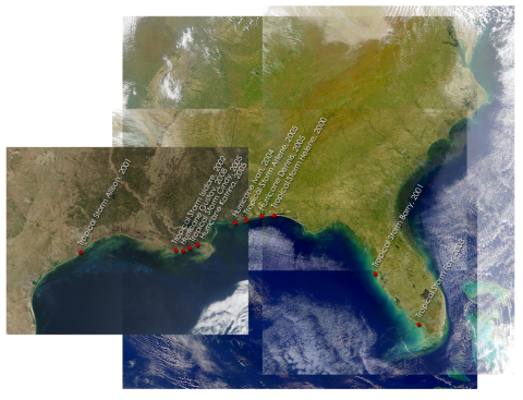 The daytime geoTIFF images from Landsat 5 and Landsat 7 were analyzed for sediment re-distribution after a hurricane over the Gulf of Mexico coastline in Alabama and part of the Florida area having coordinates 31 to 27 North latitude and 90 to 84.25 West longitude. These are seasonal data for storms from 2001-2008. In addition to the analyzed files, the data files include the ESRI files for zipped bands and grids, metadata, and storm temporal information for the sediment analysis images.