GHRC News

2013 AGU Fall Meeting

Dr. Rahul Ramachandran represented GHRC at the 2013 AGU Fall Meeting in San Francisco. He organized two sessions on Big Data titled: "Big Data Analytic Systems: Computing and Collaborating Effectively in Distributed Systems with Martin Juckes (STFC), Michael Seablom (NASA), Frederic Laliberte (University of Toronto). Dr. Ramachandran was a lead author on a poster title "Collaborative workbench for cyberinfrastructure to accelerate science algorithm development". Manil Maskey (ITSC/UAH), Kwo-Sen Kuo and Christopher Lynnes (NASA/GSFC) were the other coauthors. The poster was presented in IN23B - Collaborative Frameworks and Experiences in Earth and Space Science session

In addition, Dr. Ramachandran presented "Data Albums: A synthesis engine to support case study and climatology analysis" in IN34A - Search, Discovery and Visual Representation of Scientific Data session and "Expanding the Role of an Earth Science Data System: The GHRC Innovations Lab" in IN32A - Emerging Technologies in Earth and Space Science Informatics. The latter presentation outlines an approach to infuse new technologies into the GHRC data system.

N34A-05. Data Albums: A synthesis engine to support case study and climatology analysis
Manil Maskey; Rahul Ramachandran; Ajinkya Kulkarni; Helen Conover; H Michael Goodman; Brad Zavodsky; Scott A. Braun; Brian D. Wilson

IN32A-02. Expanding the Role of an Earth Science Data System: The GHRC Innovations Lab
Helen Conover; Rahul Ramachandran; Tammy Smith; Ajinkya Kulkarni; Manil Maskey; Matt He; Ken Keiser; Sara J. Graves


GCPEx logo

GHRC published the GPM Ground Validation McGill Vertical Pointing X-Band (VertiX) Radar GCPEx dataset which collected data from January 15, 2012 to February 29, 2012 at the CARE site in Ontario, Canada as a part of the GPM Cold-season Precipitation Experiment (GCPEx). The VertiX, a vertically pointing X-band radar, can detect all precipitation targets and some ice clouds. The VertiX can also measure the Doppler velocity of precipitation targets. The GPM Ground Validation McGill Vertical Pointing X-Band (VertiX) Radar GCPEx dataset is available in netCDF format.


GCPEx logo

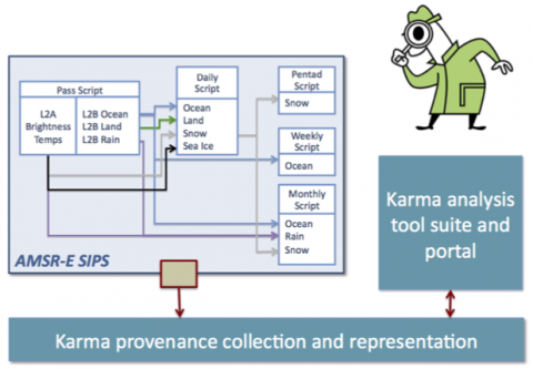
GHRC published two guides from the GPM Cold-season Precipitation Experiment (GCPEx). The GPM Ground Validation Environment Canada (EC) Vaisala Ceilometer GCPEx data were collected in Huronia, Canada from January 15, 2012 through March 1, 2012. The CT25K ceilometer uses pulsed diode laser LIDAR technology to derive backscatter profiles, cloud heights and vertical visibilities. It is also able to detect 3 cloud layers simultaneously. The GPM Ground Validation Environment Canada (EC) Radiometer GCPEx dataset contains retrievals of temperature, water vapor, relative humidity, liquid water profiles and surface parameters acquired by a passive microwave radiometer. Its data were collected in Ontario, Canada February 2012 through March 1, 2012. Data plots are available in the browse files.


GCPEx logo

GHRC published the GPM Ground Validation Dual Polarized C-Band Doppler Radar King City GCPEx dataset. This dataset of observations from Environment Canada’s operational Doppler radar at King City, Ontario (WKR) has special RHI (Range Height Indicator) and sector scans of several dual polarization parameters and was created by the C-Band radar during the GPM Cold-season Precipitation Experiment (GCPEx) in Ontario, Canada. Additionally, specially configured CARE-centric composites (Environment Canada’s Centre for Atmospheric Research Experiments) were also generated. Standard WKR IRIS (Interactive Radar Information System volume and PPI (Plan Position Indicator) scans, along with corresponding standard PPI imagery, are also included. Data was collected from January 15, 2012 through March 3, 2012.


IEEE
Provenance

IEEE has published the article describing provenance work by the AMSR-E SIPS at GHRC, including use of the “Lineage” specification for geographic metadata defined by the International Organization for Standardization in the ISO 19115-2 standard.
Conover, H.; Ramachandran, R.; Beaumont, B.; Kulkarni, A.; McEniry, M.; Regner, K.; Graves, S., "Introducing Provenance Capture into a Legacy Data System," IEEE Transactions on Geoscience and Remote Sensing, vol.51, no.11, pp.5098-5104, Nov. 2013, doi: 10.1109/TGRS.2013.2282817

http://dx.doi.org/10.1109/TGRS.2013.2282817

Have you used our data? Register for updates