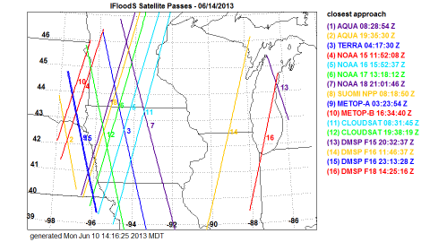
 The NASA Global Hydrology Resource Center (GHRC) DAAC published the GPM Ground Validation Satellite Overpasses IFloodS dataset. This dataset contains plots of satellite overpass paths centered over eastern Iowa during the Global Precipitation Measurement (GPM) mission Iowa Flood Studies (IFloodS) field campaign. The campaign aimed to collect detailed measurements of precipitation at the Earth’s surface while simultaneously collecting data from satellites passing overhead. This dataset consists of paths for Earth observation satellites operating during the campaign: NASA’s AQUA, TERRA, and CloudSat satellites; NOAA’s NOAA-15, NOAA-16, NOAA-17, NOAA-18, and Suomi NPP satellites; Europe’s MetOp-A and MetOp-B satellites,...
Latest Data at GHRC
01/21/2020 - 13:45
The NASA Global Hydrology Resource Center (GHRC) DAAC published the GPM Ground Validation Satellite Overpasses IFloodS dataset. This dataset contains plots of satellite overpass paths centered over eastern Iowa during the Global Precipitation Measurement (GPM) mission Iowa Flood Studies (IFloodS) field campaign. The campaign aimed to collect detailed measurements of precipitation at the Earth’s surface while simultaneously collecting data from satellites passing overhead. This dataset consists of paths for Earth observation satellites operating during the campaign: NASA’s AQUA, TERRA, and CloudSat satellites; NOAA’s NOAA-15, NOAA-16, NOAA-17, NOAA-18, and Suomi NPP satellites; Europe’s MetOp-A and MetOp-B satellites,...12/12/2019 - 15:45
DOI:...
12/06/2019 - 09:30
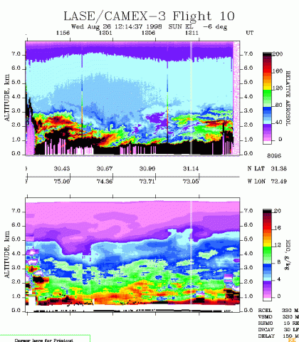 The NASA Global Hydrology Resource Center (GHRC) DAAC published the CAMEX-3 LiDAR Atmospheric Sensing Experiment (LASE) Imagery dataset. This dataset is a browse-only dataset that consists of plotted reflectivity data collected by the LiDAR Atmospheric Sensing Experiment (LASE) during the third field campaign in the Convection And Moisture EXperiment (CAMEX) series, CAMEX-3. This field campaign took place from August to September 1998 based out of Patrick Air Force Base in Florida, with the purpose of studying the various aspects of tropical cyclones in the region. The LiDAR was mounted onboard the NASA DC-8 aircraft, and the daily browse files are available from August 21 through September 5, 1998 in GIF format. It...
12/02/2019 - 11:45
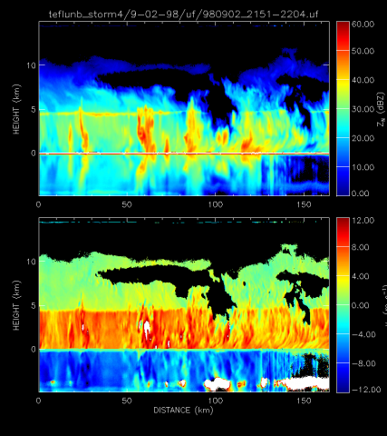 The NASA Global Hydrology Resource Center (GHRC) DAAC published the CAMEX-3 ER-2 Doppler Radar (EDOP) dataset. This dataset is a browse-only dataset that consists of plotted reflectivity and Doppler velocity data collected by the ER-2 Doppler Radar (EDOP) during the third field campaign in the Convection And Moisture EXperiment (CAMEX) series, CAMEX-3. This field campaign took place from August to September 1998 based out of Patrick Air Force Base in Florida, with the purpose of studying the various aspects of tropical cyclones in the region. EDOP was mounted onboard the NASA ER-2 high-altitude research aircraft from which it obtained vertical profiles of convection within tropical cyclones. The daily browse files are available from...
11/15/2019 - 09:00
