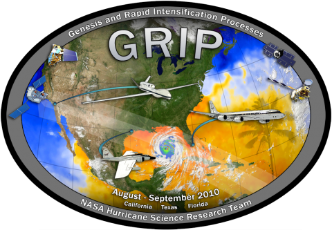
 The Genesis and Rapid Intensification Processes (GRIP) experiment was a NASA Earth science field experiment conducted August 5 to September 30, 2010. The major goal was to better understand how tropical storms form and develop into major hurricanes. NASA used the DC-8 aircraft, the WB-57 aircraft and the Global Hawk Unmanned Airborne System (UAS), configured with a suite of in situ and remote sensing instruments that were used to observe and...
GHRC News & Features
05/01/2015 - 10:31
05/01/2015 - 10:31
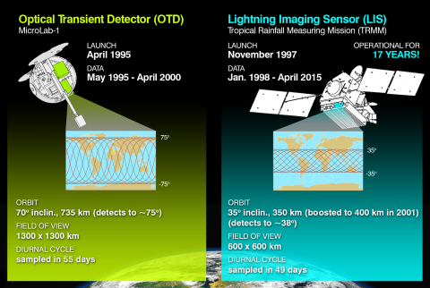 The Lightning Imaging Sensor (LIS) Science Team announces the release of version 2.3.2011 of the LIS/OTD Climatology data sets. The LIS/OTD Climatology data sets consist of gridded climatologies of total lightning flash rates seen by the spaceborne Optical Transient Detector (OTD) and Lightning Imaging Sensor (LIS). These data sets can be ordered from the GHRC DAAC using HyDRO....
05/01/2015 - 10:31
The Global Hydrology Resource Center (GHRC DAAC), a NASA Earth science data center managed by the University of Alabama in Huntsville, is pleased to announce the release of the version 7 SSMI/SSMIS F08, F10, F11, F13, F14, F15, F16, F17 Ocean Product Suite from Remote Sensing Systems (RSS) in netCDF (v4) format. These data are generated by the Distributed Information Services for Climate and Ocean Products and Visualizations for Earth Research project, (DISCOVER), PI Frank Wentz, as part of the NASA Making Earth Science Data Records for Use in Research...
05/01/2015 - 10:31
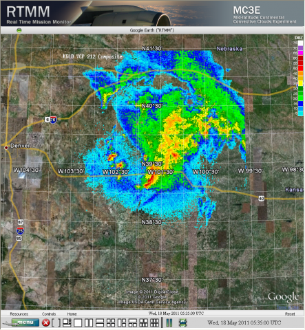
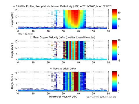 The full suite of S-band profiler datasets from the GPM Ground Validation Midlatitude Continental Convective Clouds Experiment (MC3E) is now available:
GPM Ground Validation NOAA S-Band Profiler Minute Data MC3E
...
05/01/2015 - 10:31
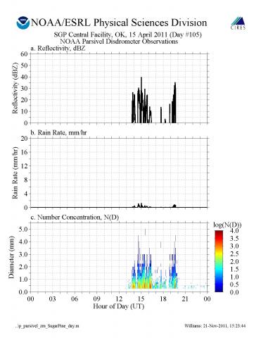 The GPM Ground Validation NOAA Parsivel MC3E data collected during the Midlatitude Continental Convective Clouds Experiment (MC3E) experiment in central Oklahoma contains moment data (reflectivity and rain rate estimates) or raindrop number concentration estimates. This data provided a reference reflectivity to calibrate the S-band profiler during the...
05/01/2015 - 10:31
 GHRC has published the GPM Ground Validation NOAA UHF 449 Profiler Raw Data SPC dataset. Using a phased array antenna configured to only point in the vertical direction, during MC3E the 449 MHz profiler measured the vertical air motion from approximately 200 to 2000 meters above the ground when precipitation passed over the profiler site. The original SPC format requires...
05/01/2015 - 10:30
The NAMMA Lightning ZEUS Data at the GHRC has been updated and now contains data from Europe and Brazil as well as Africa. The NAMMA ZEUS data is provided by World-ZEUS Long Range Lightning Monitoring Network Data obtained from sferics located at thirteen ground stations spread across the European and African continents and Brazil. Lightning activity occurring over a large part of the globe is continuously monitored at varying spatial accuracy (e.g. 10-20 km within and >50 km outside the network periphery) and high temporal (1 msec) resolution....
05/01/2015 - 10:30
GHRC published two radar datasets in support of NASA ER-2 instrumentation data for the Midlatitude Continental Convective Clouds Experiment (MC3E) held in Oklahoma in 2011. The GPM Ground Validation Pawnee Radar MC3E is a single polarization (V polarization) Doppler radar and the GPM Ground Validation CHILL Radar MC3E is a dual linear polarization Doppler Radar operated by Colorado State University. Data from both radars were collected while the NASA ER-2 aircraft conducted...
05/01/2015 - 10:30
 GHRC has published the GPM Ground Validation Flight Summaries and Flight Tracks Imagery MC3E dataset which provides processed summaries from University of North Dakota including sonde maps, a radar animation, parameter versus time charts, radar track graphs, as well as aircraft and instrument operational times for flights during the ...
05/01/2015 - 10:30
![]() GHRC has started publishing data from the the GPM Cold-season Precipitation Experiment (GCPEx). The GPM Ground Validation DC-8 Navigation and Housekeeping Data GCPEX dataset is composed of two types of files. National Suborbital Education and Research Center (NSERC) of the University of North Dakota (UND) provided the geo-located housekeeping data containing the altitude,...
GHRC has started publishing data from the the GPM Cold-season Precipitation Experiment (GCPEx). The GPM Ground Validation DC-8 Navigation and Housekeeping Data GCPEX dataset is composed of two types of files. National Suborbital Education and Research Center (NSERC) of the University of North Dakota (UND) provided the geo-located housekeeping data containing the altitude,...
