![]() GHRC has published the GPM Ground Validation DC-8 Camera Nadir GCPEx dataset. This dataset contains geo-located visible-wavelength imagery of the ground obtained from the nadir camera aboard the NASA DC-8 in Canada during the Cold-season Precipitation experiment. The data is available only for February 20, 2012, a clear-air flight day. DC-8 Camera nadir data may be...
GHRC has published the GPM Ground Validation DC-8 Camera Nadir GCPEx dataset. This dataset contains geo-located visible-wavelength imagery of the ground obtained from the nadir camera aboard the NASA DC-8 in Canada during the Cold-season Precipitation experiment. The data is available only for February 20, 2012, a clear-air flight day. DC-8 Camera nadir data may be...
GHRC News & Features
05/01/2015 - 10:30
05/01/2015 - 10:30
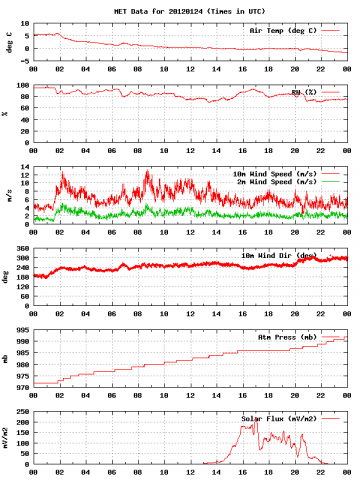 GHRC has released the GPM Ground Validation Meteorological Tower Environment Canada GCPEx dataset as part of the GPM Cold-season Precipitation Experiment (GCPEx) where data was gathered over the Ontario region of Canada in 2012 from Jan 15 through March 1. This dataset provides temperature, relative humidity, 10m winds, pressure...
05/01/2015 - 10:30
![]() GHRC has published the GPM Ground Validation Compact Scanning Millimeter-wave Imaging Radiometer (CoSMIR) GCPEx dataset. The CoSMIR plays the role as an airborne high-frequency simulator for the GPM Microwave Imager (GMI), which will launch in 2014. The CoSMIR was modified with a new scan mode to acquire both conical and cross-track scan data simultaneously in...
GHRC has published the GPM Ground Validation Compact Scanning Millimeter-wave Imaging Radiometer (CoSMIR) GCPEx dataset. The CoSMIR plays the role as an airborne high-frequency simulator for the GPM Microwave Imager (GMI), which will launch in 2014. The CoSMIR was modified with a new scan mode to acquire both conical and cross-track scan data simultaneously in...
05/01/2015 - 10:30
![]() GHRC has released GPM Ground Validation Airborne Second Generation Precipitation Radar (APR-2) GCPEx dataset. The Second Generation Airborne Precipitation Radar (APR-2) is a dual-frequency (13 GHz and 35 GHz), Doppler, dual-polarization radar system. It has a downward looking antenna that performs cross track scans, covering a swath that is +/- 25 to each side of the...
GHRC has released GPM Ground Validation Airborne Second Generation Precipitation Radar (APR-2) GCPEx dataset. The Second Generation Airborne Precipitation Radar (APR-2) is a dual-frequency (13 GHz and 35 GHz), Doppler, dual-polarization radar system. It has a downward looking antenna that performs cross track scans, covering a swath that is +/- 25 to each side of the...
05/01/2015 - 10:30
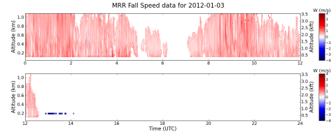 GHRC has released the GPM Ground Validation Environment Canada (EC) Micro Rain Radar (MRR) GCPEx dataset. Environment Canada (EC) collected data from the Micro Rain Radar (MRR) during the GPM Cold-season Precipitation Experiment (GCPEx) in Ontario, Canada during the winter season 2012. Operating at 24 GHz the MRR, a vertically pointing Doppler radar, retrieved...
05/01/2015 - 10:30
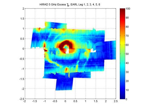 GHRC has updated the GRIP Hurricane Imaging Radiometer (HIRAD) dataset with new files containing rain rates and wind speed from Hurricane Earl (September 1-2, 2010) as an addition to the original brightness temperature files. The HIRAD flew aboard the WB-57 aircraft from Houston, Texas during the Genesis and Rapid Intensification Processes (GRIP)...
05/01/2015 - 10:30

GHRC completed the guide for the GPM Ground Validation Oklahoma...
05/01/2015 - 10:30
GHRC has published the guide for the GPM Ground Validation NOAA...
05/01/2015 - 10:30
GHRC has published two datasets from Light Precipitation Evaluation Experiment (LPVEx): ...
