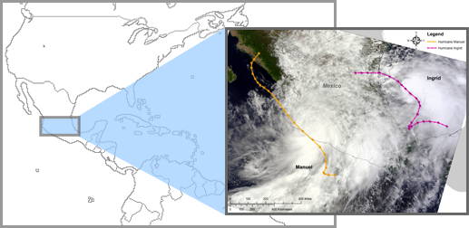
Assessing Wind and Rain in Hurricane Ingrid during Hurricane and Severe Storm Sentinel (HS3) Field Campaign
What happened and why it happened
Can areas of heavy rain and wind be identified within Ingrid ahead of landfall?
The Hurricane and Severe Storm Sentinel (HS3) airborne field campaign studied processes that influence hurricane formation and intensity change in the Atlantic Ocean basin. HS3 leveraged two NASA Global Hawk unmanned aerial systems which can fly for up to 24 hours, have an 8,500 nautical mile range and are capable of carrying large payloads of scientific instruments. During the September 15, 2013 flight, Global Hawk 871, carrying the HIWRAP, HIRAD, and HAMSR instruments, flew over Hurricane Ingrid. A few passes were made through Ingrid before extreme cold temperatures forced the Global Hawk to return to base. Data collected during the HS3 field campaign, including the September 15th Ingrid flight, are available at the GHRC DAAC.
- Braun, S.A., P.A. Newman, and G.M. Heymsfield, (2016): NASA’s Hurricane and Severe Storm Sentinel (HS3) Investigation, Bulletin of the American Meteorological Society 97, 2085-102, http://dx.doi.org/10.1175/BAMS-D-15-00186.1
- Brown, S.T., B. Lambrigtsen, et al., (2011): The High-Altitude MMIC Sounding Radiometer for the Global Hawk Unmanned Aerial Vehicle: Instrument Description and Performance, IEEE Transactions of Geoscience and Remote Sensing, 49, 3291-3301, http://dx.doi.org/10.1109/TGRS.2011.2125973.
- Didlake, A.C., G.M. Heymsfield, et al., (2015): The Coplane Analysis Technique for Three-Dimensional Wind Retrieval Using the HIWRAP Airborne Doppler Radar, Journal of Applied Meteorology and Climatology 54, 605-23, http://dx.doi.org/10.1175/JAMC-D-14-0203.1
- Rodger, C.J., J.B. Brundell, and R.L. Dowden, (2005): Location accuracy of VLF World Wide Lightning Location (WWLL) network: Post-algorithm upgrade. Annales Geophysicae, 23, 277–290.
- Ruf, C.; J.B. Roberts, et al., (2012): Calibration and image reconstruction for The Hurricane Imaging Radiometer (HIRAD), Geoscience and Remote Sensing Symposium (IGARSS), International Geoscience and Remote Sensing Symposium , Munich, 2012 22-27 July 2012, pp.4641,4643, http://dx.doi.org/10.1109/IGARSS.2012.6350431
Nov 15th, 2018


