GHRC News
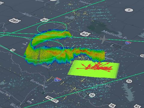
 The NASA Global Hydrology Resource Center (GHRC) DAAC coordinated with NASA Earthdata to present the webinar, “Improving the DAAC User Experience with Cloud-based Capabilities.” The presentation took place on July 23, 2020 and is the annual webinar GHRC provides to Earthdata. The webinar focused on GHRC’s transition to a cloud-based archive. This included the reasons for the transition as well as how this transition affects users, both data providers and data users. The key part of the presentation was the live demonstration of the Field Campaign eXplorer (FCX) highlighting this system and providing a publicly accessible link (http://ghrc-fcx-app.s3-website-us-west-2.amazonaws.com/).
The webinar can be accessed via:
Direct Link: https://earthdata.adobeconnect.com/ptn39o940acq/
NASA Earthdata YouTube Link: https://youtu.be/XzOmHN2_dRE
Webinar: Improving the DAAC User Experience with Cloud-based Capabilities | Earthdata
NASA EOSDIS webinar to be held on July 23, 2020 to learn more about GHRC activities to transition the user experience to the cloud.
Come join us for our next webinar!
"This presentation will discuss NASA's Global Hydrology Resource Center Distributed Active Archive Center (GHRC DAAC) activities to transition the user experience to the cloud, how these efforts are being applied (e.g., tools, visualizations, and analysis), and how this supports users."
Thursday, July 23, 2020 at 2:00 pm EDT.
Our speaker will be Geoffrey Stano, from the GHRC DAAC.
For information or to register: https://go.nasa.gov/2Zu1BnD
