GHRC News
https://earthdata.nasa.gov/learn/user-resources/webinars-and-tutorials/webinar-asdc-18-nov-2020
Join us for an introduction to the Earthdata Forum, a hub for submitting your questions about NASA Earth science data, services, and tools and for finding answers on how to discover and use the data distributed by the DAACs represented on the Earthdata Forum.
Event Details
Presenter: Crystal Gummo, ASDC DAAC
Event Date(s) and Time(s):
- Nov 18, 2020 at 2:00 PM EST - Nov 18, 2020 at 3:00 PM EST
Location: Online
Hosted by: NASA EOSDIS
Organized by: EOSDIS Communications Team
Event Type: Webinar
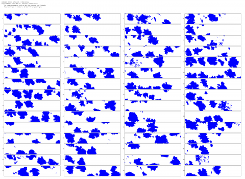 The NASA Global Hydrology Resource Center (GHRC) DAAC published the NCAR Particle Probes IMPACTS dataset. This dataset consists of data collected from five instruments on the NASA P-3 aircraft, the SPEC Hawkeye Cloud Particle Imager (CPI) and Fast Cloud Droplet Probe (FastCDP), the SPEC Two-Dimensional Stereo probe (2D-S), and two SPEC High Volume Precipitation Spectrometers (HVPS3). The 2D-S and HVPS3 are two-dimensional optical array probes which record images of particles that travel through their sampling area. The recorded images are then analyzed to produce particle size distributions from 20 microns to 3 centimeters in diameter. The FastCDP is a forward scattering instrument designed to measure the size and concentration of cloud droplets between 2 and 50 microns in diameter. The CPI is a high-resolution imager with a 256-level color depth. No particle concentration estimates have been attempted with the CPI. These data were collected during the Investigation of Microphysics and Precipitation for Atlantic Coast-Threatening Snowstorms (IMPACTS) field campaign, a three-year sequence of winter season deployments conducted to study snowstorms over the U.S Atlantic coast. IMPACTS aimed to (1) Provide observations critical to understanding the mechanisms of snowband formation, organization, and evolution; (2) Examine how the microphysical characteristics and likely growth mechanisms of snow particles vary across snowbands; and (3) Improve snowfall remote sensing interpretation and modeling to significantly advance prediction capabilities. Data files are available in netCDF-4 format, as well as browse imagery available in PNG format, from January 18, 2020 through February 26, 2020.