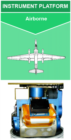
 The NASA Global Hydrology Resource Center (GHRC) DAAC published the Conical Scanning Millimeter-wave Imaging Radiometer (CoSMIR) instrument micro article. The CoSMIR instrument is an airborne, 9-channel radiometer originally developed to calibrate and validate the Special Sensor Microwave Imager/Sounder (SSMIS) for the Defense Meteorological Satellite Project. It has been modified to serve as a high-frequency simulator for the Global Precipitation Measurement Microwave Imager (GMI). CoSMIR measures microwave brightness temperatures enabling its use in satellite validation, precipitation, convection, and cloud studies, as well as tropical cyclone research. This micro article provides an overview of CoSMIR and its applications to support current and future GHRC publications. The micro article is available at: https://ghrc.nsstc.nasa.gov/home/micro-articles/instrument-conical-scanning-millimeter-wave-imaging-radiometer-cosmir
GHRC News
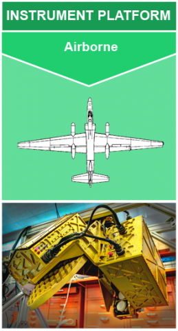 The NASA Global Hydrology Resource Center (GHRC) DAAC published the High Altitude Imaging Wind and Rain Airborne Profiler (HIWRAP) instrument micro article. The HIWRAP instrument is a Doppler radar designed to measure tropospheric winds through deriving Doppler profiles from cloud and precipitation volume backscatter. The winds are generated by combining conical scan mode measurements at two different frequency bands and incidence angles. HIWRAP has flown science flights on the NASA high-altitude (20 km) Global Hawk Unmanned Aerial Vehicle (UAV) and the NASA ER-2. The instrument is able to measure the tropospheric winds above heavy rain at high levels. HIWRAP has also been used to study precipitation microphysics as well as precipitation characterization and process studies. This micro article provides an overview of HIWRAP and its applications to support current and future GHRC publications. The micro article is available at: https://ghrc.nsstc.nasa.gov/home/micro-articles/instrument-high-altitude-imaging-wind-and-rain-airborne-profiler-hiwrap.
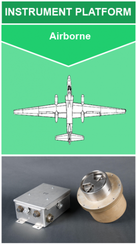 The NASA Global Hydrology Resource Center (GHRC) DAAC published the Lightning Instrument Package (LIP) instrument micro article. Comprised of 5-8 electric field mills deployed on an aircraft, LIP observes the three-dimensional components of the electric field. LIP does this by observing the changes in the environmental electric field. LIP is capable of measuring this in a wide range of conditions, ranging from fair weather to thunderstorms. These observations are used in a variety of research areas including lightning production and activity as well as storm intensification. LIP is similar to ground-based field mills, but with the obvious advantage of being able to target specific storms. LIP has been widely used in several tropical cyclone field campaigns. This micro article provides an overview of LIP and its applications to support current and future GHRC publications of LIP. The micro article is available at: https://ghrc.nsstc.nasa.gov/home/micro-articles/instrument-lightning-instrument-package-lip
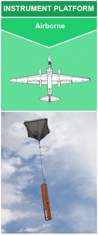 The NASA Global Hydrology Resource Center (GHRC) DAAC published the Airborne Vertical Atmospheric Profiling System (AVAPS) instrument micro article. AVAPS observes vertical profiles of key atmospheric variables, including temperature, pressure, humidity, wind speed, and wind direction. These measurements are taken by a parachuted GPS dropsonde launched from the aircraft and descends to the surface. As the AVAPS dropsonde descends it continuously measures the atmospheric variables listed from its release altitude to the surface every 0.25 s for the wind variables and 0.5 s for the others. AVAPS has been widely deployed in multiple field campaigns and aircraft platforms. AVAPS has contributed to tropical cyclone research and weather forecasting. The micro article provides an overview of AVAPS and its applications to support current and future GHRC publications of AVAPS. The micro article is available at: https://ghrc.nsstc.nasa.gov/home/micro-articles/instrument-airborne-vertical-atmospheric-profiling-system-avaps.
