
Disclaimer: The CAMEX-4 experiment concluded several years ago, and some of the links below may no longer function correctly.
|
Latitude/Longitude
|
|
|
NAS Jacksonville:
|
30.25N, -81.75W
|
|
Andros Island:
|
24.7N, -77.75W
|
|
KAMP :
|
25.0N, -82.0W
|
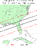 The TRMM Overflight Finder enables CAMEX-4 users to search for passes of the TRMM satellite near field locations or at the centroid of a hurricane. Select a latitude/longitude for a CAMEX-4 field site from the table or find the center of an active storm from the National Hurricane Center and enter the location and date range in the TRMM Overflight Finder web site. WARNING: The TRMM satellite may be reboosted into a higher altitude orbit (~401 km) on or about 1 August 2001. It will take about one week to boost the orbit. During that time the accuracy of the orbit finder will degrade.
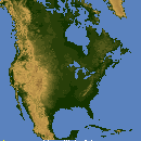
The Terra Orbit Finder displays a graphic of the sub satellite nadir track over North America. The time of the overpass is listed along the flight track. Select a day within the one week date range.
The Global Hydrology Research Center's Coincident Satellite Search Engine may be used to search for times when one to four satellites were within the same geographic location simultaneously. Searches may be constrained by time, geographic area, and/or distance between the sub-satellite points.
 The NASA J-Track utility allows the view to see the sub-satellite position of multiple satellites (Terra, QuikSCAT, TRMM, etc.) and to view the most recent orbit. You can toggle the satellite background image on/off and select a longitude for the next overpass by the satellite.
The EVDC Satellite Overpass Predictor gives a tabular output of the time, azimuth, and elevation when the selected satellite will overpass a set latitude/longitude or a selected city.
