
GHRC News

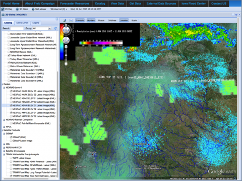
IFloodS data viewer
IFloodS logo

On Tuesday, June 11, 2013, there was a video chat on the IFloodS field campaign including PI Walt Petersen.
See this link to view a playback of the 1hr video chat: http://spaceref.com/earth/nasas-iowa-flood-study-hangout.html

Dr. Walt Petersen leads the Field Support Office at NASA GSFC’s Wallops Flight Facility and oversees the Wallops Precipitation Research Facility.  He is the NASA GPM Ground Validation Science Manager, serves as Lead Scientist on the GPM-GV field campaigns, including IFloodS, which is going on now.

GHRC is supporting IFloodS with a collaboration portal for sharing weather forecasts, instrument status, mission science reports and plans of the day, as well as real-time data acquisition and visualization tools.  We are the data archive for all the GPM GV field campaigns.

IFloodS logoThe official start of the Global Precipitation Mission (GPM) Ground Validation Iowa Flood Studies (IFloodS) Field Experiment begins on May 1, 2013. See https://ghrc.nsstc.nasa.gov/home/field-campaigns/ifloods for the experiment overview. 

To support the scientists in the field, the GHRC has developed a Drupal-based collaboration portal (no longer active) complete with instrument status reports, weather forecasts, schedules, mission reports, documents, and links to external datasets. 

Numerous datasets and browse images have been ingested and uploaded to a Public FTP server (registration required) and the majority of those native datasets have been loaded into either a THREDDS (Thematic Realtime Environmental Distributed Data Services) data server or GeoServer (an open source software server written in Java that allows users to share and edit geospatial data) for display on either a 2D Mercator or 3D Globe.  In addition, four of the NEXRAD (Next-Generation Radar) Level-2 datasets are being “animated” to show the last ten images in motion.


MC3E logo

GHRC has published the guide for the GPM Ground Validation NOAA Surface Meteorological Station MC3E dataset. The data collected for the Midlatitude Continental Convective Clouds Experiment (MC3E) at the NOAA Southern Great Plains Facility includes wind speed and direction, temperature and humidity, and precipitation. The instruments gathering this data were a propeller wind monitor located 10 meters above the ground, a temperature and humidity sensor at the ground, and a tipping rain gauge at the ground.


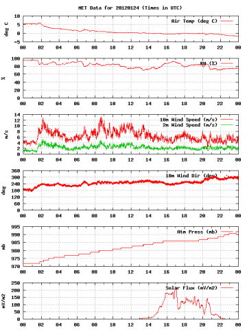
Sample browse imageGHRC has released the GPM Ground Validation Meteorological Tower Environment Canada GCPEx dataset as part of the GPM Cold-season Precipitation Experiment (GCPEx) where  data was gathered over the Ontario region of Canada in 2012 from Jan 15 through March 1. This dataset  provides temperature, relative humidity, 10m winds, pressure and solar radiation data collected by a suite of standard meteorological instruments attached to a 10m met tower.  The observation station was assembled by Automated Transportable Meteorological Observation Station (ATMOS). Browse images are available on-line.


ICSU-WDS logo

GHRC’s application for membership in the International Council for Science (ICSU) World Data System (WDS) has been accepted by the WDS Scientific Committee (WDS-SC). Pending the finalization of a signed agreement with ICSU, GHRC will be a Regular Member of ICSU-WDS.


Have you used our data? Register for updates