GHRC News


GHRC DAAC just published the GPM Ground Validation Two-Dimensional Video Disdrometer (2DVD) OLYMPEX dataset: http://dx.doi.org/10.5067/GPMGV/OLYMPEX/2DVD/DATA/301

The GPM Ground Validation Two-Dimensional Video Disdrometer (2DVD) OLYMPEX data were collected during the GPM Ground Validation Olympic Mountain Experiment (OLYMPEX) held on the Olympic Peninsula in the Pacific Northwest of the United States. Collected from four sites, the data contains daily ASCII-tsv files with information on individual hydrometeors including the number of hydrometeors, raindrop size distribution, and particle concentration. The data range from October 31, 2015 through January 17, 2016; exact dates may vary per site, and these data are available in ASCII-tsv format.

GHRC DAAC has published the GPM Ground Validation Cloud Radar System (CRS) OLYMPEX dataset: 
http://dx.doi.org/10.5067/GPMGV/OLYMPEX/CRS/DATA101

The GPM Ground Validation Cloud Radar System (CRS) OLYMPEX dataset provides radar reflectivity and Doppler velocity data collected during the Olympic Mountain Experiment (OLYMPEX). This dataset is used to estimate cloud droplet distribution for the storms monitored during the field campaign. The CRS instrument is a 94GHz W-band Doppler radar with a 3mm wavelength. CRS can be deployed as both an airborne instrument onboard NASA’s high-altitude science aircraft, the Earth Resource 2 (ER-2), as well as a ground based radar system. Only the airborne mode was used during OLYMPEX. In addition to reflectivity and Doppler velocity, the data files include aircraft flight information. The CRS was flown on 10 different days between November 10, 2015 and December 10, 2015. Each data file contains one hour of flight measurements during flight in UTC time. Files for this dataset are in netCDF-3 format and readily accessible without the need of specialized software.

GPM Ground Validation UND Citation Navigation Data OLYMPEX:
http://dx.doi.org/10.5067/GPMGV/OLYMPEX/NAV/DATA101

OLYMPEX logoThe GPM Ground Validation UND Citation Navigation Data OLYMPEX dataset supplies navigation data collected by the Cessna Citation II aircraft for flights that occurred during November 12, 2015 through December 19, 2015 for the Olympic Mountains Experiment (OLYMPEX) GPM Ground Validation field campaign. This navigation dataset consists of multiple altitude, pressure, temperature, airspeed, and ground speed measurements in ASCII format.
 

GHRC DAAC has published the GPM Ground Validation Doppler on Wheels (DOW) OLYMPEX dataset: http://dx.doi.org/10.5067/GPMGV/OLYMPEX/DOW/DATA101

The GPM Ground Validation Doppler on Wheels (DOW) OLYMPEX dataset was obtained by a dual-polarization and dual-frequency X-band mobile radar operated by the Center for Severe Weather Research (CSWR) during the Olympic Mountain Experiment (OLYMPEX) campaign. The DOW was deployed in the Chehalis Valley for the OLYMPEX field campaign with the goal of obtaining radar reflectivity observations of precipitation in order to better understand the orographic enhancement of precipitation during frontal passages over mountain ranges. The DOW radar uses two 250 kW transmitters with a measurement range of roughly 60 km. CF-Radial data files are available from 06 November 2015 to 15 January 2016 in the netCDF-4 file format. There is 1 radar volume per file representing 10 minutes of data.

GHRC DAAC has published three more OLYMPEx datasets:

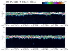
Sample OLYMPEX CPL browse image

The GPM Ground Validation Cloud Physics Lidar (CPL) OLYMPEX dataset (image shown) consists of extinction profiles, layer optical depth, layer lidar ratio, and aircraft parameter measurements measured by the CPL flown on the NASA ER-2 aircraft during the Global Precipitation Mission (GPM) Olympic Mountains Experiment (OLYMPEX) campaign. http://dx.doi.org/10.5067/GPMGV/OLYMPEX/CPL/DATA101

The GPM Ground Validation Advanced Vertical Atmospheric Profiling System (AVAPS) OLYMPEX dataset contains dropsonde vertical profiles of atmospheric pressure, air temperature, dew point temperature, relative humidity, wind direction and magnitude, and sensor location obtained during the Olympic Mountains Experiment (OLYMPEX). http://dx.doi.org/10.5067/GPMGV/OLYMPEX/AVAPS/DATA101

The GPM Ground Validation NASA ER-2 Navigation Data OLYMPEX dataset supplies navigation data collected by the NASA ER-2 aircraft for flights that occurred during November 9, 2015 through December 15, 2015 for OLYMPEX. This navigation dataset consists of multiple altitude, pressure, temperature parameters, airspeed, and ground speed measurements in ASCII, ASCII-IWG1, and XML data file formats. http://dx.doi.org/10.5067/GPMGV/OLYMPEX/NAV/DATA201

Have you used our data? Register for updates