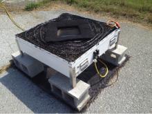
 The NASA Global Hydrology Resource Center (GHRC) DAAC published a Micro Article about the Two-Dimensional Video Disdrometer (2DVD) instrument. A disdrometer is an optical device situated on a stationary ground station platform that measures properties of different hydrometeor (precipitation) types such as raindrops, snowflakes, and hail. This Micro Article and associated datasets at the NASA GHRC DAAC may be accessed here:https://ghrc.nsstc.nasa.gov/home/micro-articles/instrument-2dvd-disdrometer
GHRC News
The Global Hydrology Resource Center (GHRC) DAAC has published all four of the GPM Ground Validation NEXRAD Level III IFloodS datasets. The purpose of the IFloodS campaign was to help support the ground validation of the Global Precipitation Measurement (GPM). NEXt Generation Weather RADar system (NEXRAD) Level-II data were previously published. These Level-III NEXRAD precipitation products were gathered from Unidata for four NEXRAD stations in the vicinity of the IFloodS campaign during March 29, 2013 through June 18, 2013. These datasets contain data files of digital instantaneous precipitation rate (DPR) and storm total accumulation estimates (DTA) in NIDS binary format. For a complete archive of data from each station beyond the IFloodS time period, please utilize the NOAA archives at Amazon Web Services and Open Common Consortium. See the NOAA website at https://www.ncdc.noaa.gov/data-access/radar-data/noaa-big-data-project for more information.
- GPM Ground Validation NEXRAD Level III KARX IFloodS (http://dx.doi.org/10.5067/GPMGV/IFLOODS/NEXRAD/DATA201)
- GPM Ground Validation NEXRAD Level III KMPX IFloodS (http://dx.doi.org/10.5067/GPMGV/IFLOODS/NEXRAD/DATA501)
- GPM Ground Validation NEXRAD Level III KDVN IFloodS (http://dx.doi.org/10.5067/GPMGV/IFLOODS/NEXRAD/DATA301)
- GPM Ground Validation NEXRAD Level III KDMX IFloodS (http://dx.doi.org/10.5067/GPMGV/IFLOODS/NEXRAD/DATA401)
GHRC DAAC has published the NOXP IPHEx dataset: http://dx.doi.org/10.5067/GPMGV/IPHEX/NOXP/DATA101
The GPM Ground Validation NOAA X-band dual-Polarimetric radar (NOXP) IPHEx dataset consists of differential reflectivity, differential phase shift, co-polar cross correlation, radial Doppler velocity, spectrum width, signal index, melting layer index, reflectivity, drop size distribution, and rainfall rate observations, as well as other radar parameters, collected by NOXP mobile radar during the GPM Integrated Precipitation and Hydrology Experiment (IPHEx) field campaign. The IPHEx field campaign occurred in the Southern Appalachians, spanning into the Piedmont and Coastal Plain regions of North Carolina. The NOXP radar, operated by the NOAA National Severe Storm Laboratory (NSSL), was positioned in the Pigeon River basin of the Great Smoky Mountains of North Carolina. NOXP data are available in netCDF-3 format for dates between April 21, 2014 through June 15, 2014. The dataset includes weather condition photos taken at the NOXP radar site in JPG format.
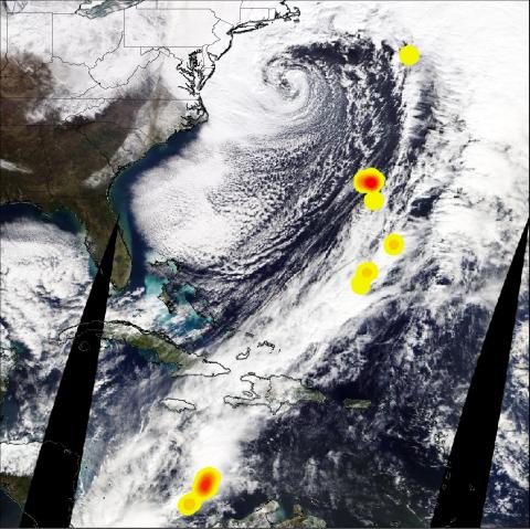 Explosive intensification of mid-latitude cyclones is sometimes referred to as ‘bombogenesis’ or a ‘bomb cyclone’. On January 4, 2018 a bomb cyclone brought hazardous winter weather to the U.S. East Coast and generated lightning that was observed from space. The Lightning Imaging Sensor (LIS) aboard the International Space Station (ISS) captured lightning along the frontal boundary of the cyclone in GHRC’s Non-Quality Controlled ISS LIS Provisional Science Data. Lightning flash locations from this dataset were used to create this density plot showing lighting occurrence from low (yellow) to high (red) densities. These lightning flash location densities are overlaid on Terra/MODIS True Color Imagery. In this image you can see the storm system moving northward off the mid-atlantic coast towards New England. Snow deposited from the bomb cyclone is shown as white areas across Virginia, Georgia and North/South Carolina.
Changes have been made to Infrared Global Geostationary Composite data: http://dx.doi.org/10.5067/GHRC/MULTIPLE/DATA201.
The main revision is that the incorporation of GOES-16 data has modified the resolution of this data from 14km to 4 km. The change in resolution results in larger files. The files changed size on December 18, 2017. The updated guide provides more information.
